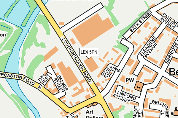
LE4 5PN is located in the Rushey Mead electoral ward, within the unitary authority of Leicester and the English Parliamentary constituency of Leicester East. The Sub Integrated Care Board (ICB) Location is NHS Leicester, Leicestershire and Rutland ICB - 04C and the police force is Leicestershire. This postcode has been in use since January 1980.


GetTheData
Source: OS OpenMap – Local (Ordnance Survey)
Source: OS VectorMap District (Ordnance Survey)
Licence: Open Government Licence (requires attribution)
| Easting | 459315 |
| Northing | 307422 |
| Latitude | 52.661282 |
| Longitude | -1.124458 |
GetTheData
Source: Open Postcode Geo
Licence: Open Government Licence
| Country | England |
| Postcode District | LE4 |
➜ See where LE4 is on a map ➜ Where is Leicester? | |
GetTheData
Source: Land Registry Price Paid Data
Licence: Open Government Licence
Elevation or altitude of LE4 5PN as distance above sea level:
| Metres | Feet | |
|---|---|---|
| Elevation | 50m | 164ft |
Elevation is measured from the approximate centre of the postcode, to the nearest point on an OS contour line from OS Terrain 50, which has contour spacing of ten vertical metres.
➜ How high above sea level am I? Find the elevation of your current position using your device's GPS.
GetTheData
Source: Open Postcode Elevation
Licence: Open Government Licence
| Ward | Rushey Mead |
| Constituency | Leicester East |
GetTheData
Source: ONS Postcode Database
Licence: Open Government Licence
| New Bridge (Loughborough Road) | Belgrave | 41m |
| New Bridge (Loughborough Road) | Belgrave | 85m |
| Talbot Street (Thurcaston Road) | Belgrave | 176m |
| Bath Street (Loughborough Road) | Belgrave | 179m |
| Church Road (Thurcaston Road) | Belgrave | 180m |
| Leicester North (Great Central Railway) | Birstall | 892m |
| Leicester Station | 3.3km |
| Syston Station | 4.6km |
GetTheData
Source: NaPTAN
Licence: Open Government Licence
| Percentage of properties with Next Generation Access | 75.0% |
| Percentage of properties with Superfast Broadband | 75.0% |
| Percentage of properties with Ultrafast Broadband | 75.0% |
| Percentage of properties with Full Fibre Broadband | 0.0% |
Superfast Broadband is between 30Mbps and 300Mbps
Ultrafast Broadband is > 300Mbps
| Median download speed | 23.2Mbps |
| Average download speed | 44.8Mbps |
| Maximum download speed | 100.00Mbps |
| Median upload speed | 1.2Mbps |
| Average upload speed | 4.4Mbps |
| Maximum upload speed | 13.14Mbps |
| Percentage of properties unable to receive 2Mbps | 0.0% |
| Percentage of properties unable to receive 5Mbps | 0.0% |
| Percentage of properties unable to receive 10Mbps | 0.0% |
| Percentage of properties unable to receive 30Mbps | 0.0% |
GetTheData
Source: Ofcom
Licence: Ofcom Terms of Use (requires attribution)
GetTheData
Source: ONS Postcode Database
Licence: Open Government Licence


➜ Get more ratings from the Food Standards Agency
GetTheData
Source: Food Standards Agency
Licence: FSA terms & conditions
| Last Collection | |||
|---|---|---|---|
| Location | Mon-Fri | Sat | Distance |
| Abbey Lane Post Office | 17:00 | 12:00 | 509m |
| Maple Road | 17:30 | 12:00 | 511m |
| Birstall Road | 17:00 | 12:00 | 691m |
GetTheData
Source: Dracos
Licence: Creative Commons Attribution-ShareAlike
The below table lists the International Territorial Level (ITL) codes (formerly Nomenclature of Territorial Units for Statistics (NUTS) codes) and Local Administrative Units (LAU) codes for LE4 5PN:
| ITL 1 Code | Name |
|---|---|
| TLF | East Midlands (England) |
| ITL 2 Code | Name |
| TLF2 | Leicestershire, Rutland and Northamptonshire |
| ITL 3 Code | Name |
| TLF21 | Leicester |
| LAU 1 Code | Name |
| E06000016 | Leicester |
GetTheData
Source: ONS Postcode Directory
Licence: Open Government Licence
The below table lists the Census Output Area (OA), Lower Layer Super Output Area (LSOA), and Middle Layer Super Output Area (MSOA) for LE4 5PN:
| Code | Name | |
|---|---|---|
| OA | E00069334 | |
| LSOA | E01013734 | Leicester 002B |
| MSOA | E02002828 | Leicester 002 |
GetTheData
Source: ONS Postcode Directory
Licence: Open Government Licence
| LE4 7QS | Overing Close | 60m |
| LE4 7QD | Bath Street | 92m |
| LE4 5PJ | Loughborough Road | 103m |
| LE4 5PT | Palmer Street | 148m |
| LE4 7QJ | Clement Avenue | 149m |
| LE4 5PS | Day Street | 153m |
| LE4 5PG | Thurcaston Road | 161m |
| LE4 7QY | Linford Street | 172m |
| LE4 5PL | Loughborough Road | 182m |
| LE4 7QZ | Elsadene Walk | 186m |
GetTheData
Source: Open Postcode Geo; Land Registry Price Paid Data
Licence: Open Government Licence