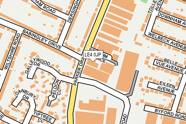
LE4 0JP lies on Parker Drive in Leicester. LE4 0JP is located in the Abbey electoral ward, within the unitary authority of Leicester and the English Parliamentary constituency of Leicester West. The Sub Integrated Care Board (ICB) Location is NHS Leicester, Leicestershire and Rutland ICB - 04C and the police force is Leicestershire. This postcode has been in use since January 1980.


GetTheData
Source: OS OpenMap – Local (Ordnance Survey)
Source: OS VectorMap District (Ordnance Survey)
Licence: Open Government Licence (requires attribution)
| Easting | 458051 |
| Northing | 306670 |
| Latitude | 52.654678 |
| Longitude | -1.143269 |
GetTheData
Source: Open Postcode Geo
Licence: Open Government Licence
| Street | Parker Drive |
| Town/City | Leicester |
| Country | England |
| Postcode District | LE4 |
➜ See where LE4 is on a map ➜ Where is Leicester? | |
GetTheData
Source: Land Registry Price Paid Data
Licence: Open Government Licence
Elevation or altitude of LE4 0JP as distance above sea level:
| Metres | Feet | |
|---|---|---|
| Elevation | 70m | 230ft |
Elevation is measured from the approximate centre of the postcode, to the nearest point on an OS contour line from OS Terrain 50, which has contour spacing of ten vertical metres.
➜ How high above sea level am I? Find the elevation of your current position using your device's GPS.
GetTheData
Source: Open Postcode Elevation
Licence: Open Government Licence
| Ward | Abbey |
| Constituency | Leicester West |
GetTheData
Source: ONS Postcode Database
Licence: Open Government Licence
121, PARKER DRIVE, LEICESTER, LE4 0JP 2004 10 AUG £475,000 |
GetTheData
Source: HM Land Registry Price Paid Data
Licence: Contains HM Land Registry data © Crown copyright and database right 2025. This data is licensed under the Open Government Licence v3.0.
| Somerset Avenue (Parker Drive) | Leicester | 155m |
| Danbury Drive (Somerset Avenue) | Leicester | 277m |
| Danbury Drive (Somerset Avenue) | Leicester | 281m |
| Somerset Avenue (Parker Drive) | Leicester | 323m |
| Wiltshire Road (Somerset Avenue) | Leicester | 331m |
| Leicester North (Great Central Railway) | Birstall | 1,537m |
| Leicester Station | 2.9km |
| Syston Station | 6km |
GetTheData
Source: NaPTAN
Licence: Open Government Licence
| Median download speed | 79.8Mbps |
| Average download speed | 72.4Mbps |
| Maximum download speed | 80.00Mbps |
| Median upload speed | 20.0Mbps |
| Average upload speed | 18.9Mbps |
| Maximum upload speed | 20.00Mbps |
GetTheData
Source: Ofcom
Licence: Ofcom Terms of Use (requires attribution)
Estimated total energy consumption in LE4 0JP by fuel type, 2015.
| Consumption (kWh) | 365,199 |
|---|---|
| Meter count | 18 |
| Mean (kWh/meter) | 20,289 |
| Median (kWh/meter) | 5,804 |
GetTheData
Source: Postcode level gas estimates: 2015 (experimental)
Source: Postcode level electricity estimates: 2015 (experimental)
Licence: Open Government Licence
GetTheData
Source: ONS Postcode Database
Licence: Open Government Licence


➜ Get more ratings from the Food Standards Agency
GetTheData
Source: Food Standards Agency
Licence: FSA terms & conditions
| Last Collection | |||
|---|---|---|---|
| Location | Mon-Fri | Sat | Distance |
| Dersingham Road | 17:00 | 12:00 | 125m |
| Frog Island | 18:30 | 12:00 | 1,002m |
| Stocking Farm Post Office | 17:00 | 12:00 | 1,007m |
GetTheData
Source: Dracos
Licence: Creative Commons Attribution-ShareAlike
The below table lists the International Territorial Level (ITL) codes (formerly Nomenclature of Territorial Units for Statistics (NUTS) codes) and Local Administrative Units (LAU) codes for LE4 0JP:
| ITL 1 Code | Name |
|---|---|
| TLF | East Midlands (England) |
| ITL 2 Code | Name |
| TLF2 | Leicestershire, Rutland and Northamptonshire |
| ITL 3 Code | Name |
| TLF21 | Leicester |
| LAU 1 Code | Name |
| E06000016 | Leicester |
GetTheData
Source: ONS Postcode Directory
Licence: Open Government Licence
The below table lists the Census Output Area (OA), Lower Layer Super Output Area (LSOA), and Middle Layer Super Output Area (MSOA) for LE4 0JP:
| Code | Name | |
|---|---|---|
| OA | E00068694 | |
| LSOA | E01013607 | Leicester 008B |
| MSOA | E02002834 | Leicester 008 |
GetTheData
Source: ONS Postcode Directory
Licence: Open Government Licence
| LE4 0HG | Babingley Drive | 91m |
| LE4 0HU | Dersingham Road | 138m |
| LE4 0HS | Dersingham Road | 154m |
| LE4 0EF | Maple Close | 158m |
| LE4 0NH | Galleywood Drive | 164m |
| LE4 0NG | Peldon Close | 164m |
| LE4 0NJ | Stadium Rise | 173m |
| LE4 0JF | Parker Drive | 179m |
| LE4 0HH | Babingley Drive | 197m |
| LE4 0HW | Dersingham Road | 216m |
GetTheData
Source: Open Postcode Geo; Land Registry Price Paid Data
Licence: Open Government Licence