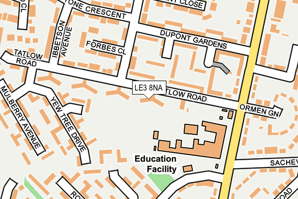
LE3 8NA lies on Tatlow Road in Glenfield, Leicester. LE3 8NA is located in the Western electoral ward, within the unitary authority of Leicester and the English Parliamentary constituency of Leicester West. The Sub Integrated Care Board (ICB) Location is NHS Leicester, Leicestershire and Rutland ICB - 04C and the police force is Leicestershire. This postcode has been in use since January 1980.


GetTheData
Source: OS OpenMap – Local (Ordnance Survey)
Source: OS VectorMap District (Ordnance Survey)
Licence: Open Government Licence (requires attribution)
| Easting | 454537 |
| Northing | 304937 |
| Latitude | 52.639446 |
| Longitude | -1.195503 |
GetTheData
Source: Open Postcode Geo
Licence: Open Government Licence
| Street | Tatlow Road |
| Locality | Glenfield |
| Town/City | Leicester |
| Country | England |
| Postcode District | LE3 |
➜ See where LE3 is on a map ➜ Where is Leicester? | |
GetTheData
Source: Land Registry Price Paid Data
Licence: Open Government Licence
Elevation or altitude of LE3 8NA as distance above sea level:
| Metres | Feet | |
|---|---|---|
| Elevation | 100m | 328ft |
Elevation is measured from the approximate centre of the postcode, to the nearest point on an OS contour line from OS Terrain 50, which has contour spacing of ten vertical metres.
➜ How high above sea level am I? Find the elevation of your current position using your device's GPS.
GetTheData
Source: Open Postcode Elevation
Licence: Open Government Licence
| Ward | Western |
| Constituency | Leicester West |
GetTheData
Source: ONS Postcode Database
Licence: Open Government Licence
| Tournament Road (Tatlow Road) | New Parks | 48m |
| Tournament Road (Tatlow Road) | New Parks | 49m |
| Forbes Close (Tournament Road) | New Parks | 100m |
| Ibbeston Avenue (Tatlow Road) | New Parks | 115m |
| Liberty Road (Tatlow Road) | New Parks | 155m |
| Leicester Station | 4.8km |
GetTheData
Source: NaPTAN
Licence: Open Government Licence
| Percentage of properties with Next Generation Access | 100.0% |
| Percentage of properties with Superfast Broadband | 100.0% |
| Percentage of properties with Ultrafast Broadband | 100.0% |
| Percentage of properties with Full Fibre Broadband | 0.0% |
Superfast Broadband is between 30Mbps and 300Mbps
Ultrafast Broadband is > 300Mbps
| Percentage of properties unable to receive 2Mbps | 0.0% |
| Percentage of properties unable to receive 5Mbps | 0.0% |
| Percentage of properties unable to receive 10Mbps | 0.0% |
| Percentage of properties unable to receive 30Mbps | 0.0% |
GetTheData
Source: Ofcom
Licence: Ofcom Terms of Use (requires attribution)
Estimated total energy consumption in LE3 8NA by fuel type, 2015.
| Consumption (kWh) | 146,076 |
|---|---|
| Meter count | 21 |
| Mean (kWh/meter) | 6,956 |
| Median (kWh/meter) | 4,763 |
| Consumption (kWh) | 51,710 |
|---|---|
| Meter count | 20 |
| Mean (kWh/meter) | 2,585 |
| Median (kWh/meter) | 2,149 |
GetTheData
Source: Postcode level gas estimates: 2015 (experimental)
Source: Postcode level electricity estimates: 2015 (experimental)
Licence: Open Government Licence
GetTheData
Source: ONS Postcode Database
Licence: Open Government Licence


➜ Get more ratings from the Food Standards Agency
GetTheData
Source: Food Standards Agency
Licence: FSA terms & conditions
| Last Collection | |||
|---|---|---|---|
| Location | Mon-Fri | Sat | Distance |
| Park Rise | 17:00 | 12:00 | 812m |
| Park View | 17:00 | 12:00 | 1,050m |
| Packer Avenue | 17:00 | 12:00 | 1,493m |
GetTheData
Source: Dracos
Licence: Creative Commons Attribution-ShareAlike
The below table lists the International Territorial Level (ITL) codes (formerly Nomenclature of Territorial Units for Statistics (NUTS) codes) and Local Administrative Units (LAU) codes for LE3 8NA:
| ITL 1 Code | Name |
|---|---|
| TLF | East Midlands (England) |
| ITL 2 Code | Name |
| TLF2 | Leicestershire, Rutland and Northamptonshire |
| ITL 3 Code | Name |
| TLF21 | Leicester |
| LAU 1 Code | Name |
| E06000016 | Leicester |
GetTheData
Source: ONS Postcode Directory
Licence: Open Government Licence
The below table lists the Census Output Area (OA), Lower Layer Super Output Area (LSOA), and Middle Layer Super Output Area (MSOA) for LE3 8NA:
| Code | Name | |
|---|---|---|
| OA | E00069259 | |
| LSOA | E01013730 | Leicester 039C |
| MSOA | E02006819 | Leicester 039 |
GetTheData
Source: ONS Postcode Directory
Licence: Open Government Licence
| LE3 8LB | Dupont Close | 77m |
| LE3 8LS | Tournament Road | 92m |
| LE3 8NF | Tatlow Road | 101m |
| LE3 8LD | Dupont Gardens | 125m |
| LE3 6PL | Yew Tree Drive | 153m |
| LE3 8LF | Forbes Close | 155m |
| LE3 6PN | Rowanberry Avenue | 166m |
| LE3 6NN | Liberty Road | 170m |
| LE3 6PJ | Yew Tree Drive | 195m |
| LE3 8LL | Pennant Close | 196m |
GetTheData
Source: Open Postcode Geo; Land Registry Price Paid Data
Licence: Open Government Licence