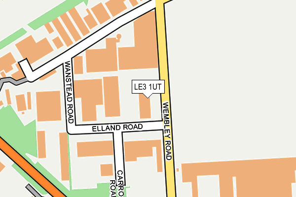
LE3 1UT lies on Wembley Road in Leicester. LE3 1UT is located in the Western electoral ward, within the unitary authority of Leicester and the English Parliamentary constituency of Leicester West. The Sub Integrated Care Board (ICB) Location is NHS Leicester, Leicestershire and Rutland ICB - 04C and the police force is Leicestershire. This postcode has been in use since October 2003.


GetTheData
Source: OS OpenMap – Local (Ordnance Survey)
Source: OS VectorMap District (Ordnance Survey)
Licence: Open Government Licence (requires attribution)
| Easting | 453789 |
| Northing | 303999 |
| Latitude | 52.631107 |
| Longitude | -1.206701 |
GetTheData
Source: Open Postcode Geo
Licence: Open Government Licence
| Street | Wembley Road |
| Town/City | Leicester |
| Country | England |
| Postcode District | LE3 |
➜ See where LE3 is on a map ➜ Where is Leicester? | |
GetTheData
Source: Land Registry Price Paid Data
Licence: Open Government Licence
Elevation or altitude of LE3 1UT as distance above sea level:
| Metres | Feet | |
|---|---|---|
| Elevation | 100m | 328ft |
Elevation is measured from the approximate centre of the postcode, to the nearest point on an OS contour line from OS Terrain 50, which has contour spacing of ten vertical metres.
➜ How high above sea level am I? Find the elevation of your current position using your device's GPS.
GetTheData
Source: Open Postcode Elevation
Licence: Open Government Licence
| Ward | Western |
| Constituency | Leicester West |
GetTheData
Source: ONS Postcode Database
Licence: Open Government Licence
| Wembley Road (Sunningdale Road) | New Parks | 38m |
| Sunningdale Road (Wembley Road) | New Parks | 108m |
| Elland Road (Wembley Road) | New Parks | 269m |
| Murrayfield Road (Sunningdale Road) | New Parks | 388m |
| Meynell's Gorse Park And Ride (Ratby Lane) | Leicester | 459m |
GetTheData
Source: NaPTAN
Licence: Open Government Licence
GetTheData
Source: ONS Postcode Database
Licence: Open Government Licence


➜ Get more ratings from the Food Standards Agency
GetTheData
Source: Food Standards Agency
Licence: FSA terms & conditions
| Last Collection | |||
|---|---|---|---|
| Location | Mon-Fri | Sat | Distance |
| Packer Avenue | 17:00 | 12:00 | 316m |
| L. F. E. Post Office | 17:30 | 12:00 | 603m |
| Kirby Lane | 17:00 | 12:00 | 1,047m |
GetTheData
Source: Dracos
Licence: Creative Commons Attribution-ShareAlike
The below table lists the International Territorial Level (ITL) codes (formerly Nomenclature of Territorial Units for Statistics (NUTS) codes) and Local Administrative Units (LAU) codes for LE3 1UT:
| ITL 1 Code | Name |
|---|---|
| TLF | East Midlands (England) |
| ITL 2 Code | Name |
| TLF2 | Leicestershire, Rutland and Northamptonshire |
| ITL 3 Code | Name |
| TLF21 | Leicester |
| LAU 1 Code | Name |
| E06000016 | Leicester |
GetTheData
Source: ONS Postcode Directory
Licence: Open Government Licence
The below table lists the Census Output Area (OA), Lower Layer Super Output Area (LSOA), and Middle Layer Super Output Area (MSOA) for LE3 1UT:
| Code | Name | |
|---|---|---|
| OA | E00069264 | |
| LSOA | E01013729 | Leicester 020A |
| MSOA | E02002846 | Leicester 020 |
GetTheData
Source: ONS Postcode Directory
Licence: Open Government Licence
| LE3 1TT | Elland Road | 192m |
| LE3 3AW | Oak Spinney Park | 195m |
| LE3 1UQ | Scudamore Road | 254m |
| LE3 1TU | Elland Road | 280m |
| LE3 3QH | Packer Avenue | 294m |
| LE3 3QJ | Packer Avenue | 317m |
| LE3 3QN | Packer Avenue | 325m |
| LE3 3QP | Packer Avenue | 358m |
| LE3 3QA | Brightwell Drive | 372m |
| LE3 3FX | Pine View | 392m |
GetTheData
Source: Open Postcode Geo; Land Registry Price Paid Data
Licence: Open Government Licence