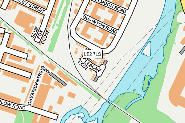
LE2 7LS lies on Marylebone Place in Leicester. LE2 7LS is located in the Westcotes electoral ward, within the unitary authority of Leicester and the English Parliamentary constituency of Leicester West. The Sub Integrated Care Board (ICB) Location is NHS Leicester, Leicestershire and Rutland ICB - 04C and the police force is Leicestershire. This postcode has been in use since June 2016.


GetTheData
Source: OS OpenMap – Local (Ordnance Survey)
Source: OS VectorMap District (Ordnance Survey)
Licence: Open Government Licence (requires attribution)
| Easting | 457822 |
| Northing | 302928 |
| Latitude | 52.621066 |
| Longitude | -1.147307 |
GetTheData
Source: Open Postcode Geo
Licence: Open Government Licence
| Street | Marylebone Place |
| Town/City | Leicester |
| Country | England |
| Postcode District | LE2 |
➜ See where LE2 is on a map ➜ Where is Leicester? | |
GetTheData
Source: Land Registry Price Paid Data
Licence: Open Government Licence
Elevation or altitude of LE2 7LS as distance above sea level:
| Metres | Feet | |
|---|---|---|
| Elevation | 60m | 197ft |
Elevation is measured from the approximate centre of the postcode, to the nearest point on an OS contour line from OS Terrain 50, which has contour spacing of ten vertical metres.
➜ How high above sea level am I? Find the elevation of your current position using your device's GPS.
GetTheData
Source: Open Postcode Elevation
Licence: Open Government Licence
| Ward | Westcotes |
| Constituency | Leicester West |
GetTheData
Source: ONS Postcode Database
Licence: Open Government Licence
2023 5 APR £340,000 |
2022 18 MAY £275,000 |
2020 9 OCT £282,500 |
22, MARYLEBONE PLACE, LEICESTER, LE2 7LS 2016 24 NOV £264,995 |
20, MARYLEBONE PLACE, LEICESTER, LE2 7LS 2016 28 OCT £262,495 |
18, MARYLEBONE PLACE, LEICESTER, LE2 7LS 2016 27 OCT £262,495 |
21, MARYLEBONE PLACE, LEICESTER, LE2 7LS 2016 30 SEP £258,495 |
2016 30 SEP £253,995 |
2016 30 SEP £260,995 |
7, MARYLEBONE PLACE, LEICESTER, LE2 7LS 2016 26 AUG £256,995 |
GetTheData
Source: HM Land Registry Price Paid Data
Licence: Contains HM Land Registry data © Crown copyright and database right 2025. This data is licensed under the Open Government Licence v3.0.
| King Power Stadium (Raw Dykes Road) | Leicester | 438m |
| Eastern Boulevard | Leicester | 461m |
| Westleigh Road (Narborough Road) | West End | 510m |
| Lidl (Upperton Road) | West End | 528m |
| Imperial Avenue (Narborough Road) | West End | 548m |
| Leicester Station | 1.9km |
| South Wigston Station | 4.4km |
GetTheData
Source: NaPTAN
Licence: Open Government Licence
| Percentage of properties with Next Generation Access | 100.0% |
| Percentage of properties with Superfast Broadband | 100.0% |
| Percentage of properties with Ultrafast Broadband | 92.0% |
| Percentage of properties with Full Fibre Broadband | 0.0% |
Superfast Broadband is between 30Mbps and 300Mbps
Ultrafast Broadband is > 300Mbps
| Median download speed | 53.7Mbps |
| Average download speed | 42.5Mbps |
| Maximum download speed | 80.00Mbps |
| Median upload speed | 12.0Mbps |
| Average upload speed | 11.2Mbps |
| Maximum upload speed | 20.00Mbps |
| Percentage of properties unable to receive 2Mbps | 0.0% |
| Percentage of properties unable to receive 5Mbps | 0.0% |
| Percentage of properties unable to receive 10Mbps | 0.0% |
| Percentage of properties unable to receive 30Mbps | 0.0% |
GetTheData
Source: Ofcom
Licence: Ofcom Terms of Use (requires attribution)
GetTheData
Source: ONS Postcode Database
Licence: Open Government Licence


➜ Get more ratings from the Food Standards Agency
GetTheData
Source: Food Standards Agency
Licence: FSA terms & conditions
| Last Collection | |||
|---|---|---|---|
| Location | Mon-Fri | Sat | Distance |
| Heyworth Road | 17:00 | 12:00 | 447m |
| Bruce Street | 17:30 | 12:00 | 453m |
| Imperial Avenue Post Office | 17:00 | 12:00 | 534m |
GetTheData
Source: Dracos
Licence: Creative Commons Attribution-ShareAlike
The below table lists the International Territorial Level (ITL) codes (formerly Nomenclature of Territorial Units for Statistics (NUTS) codes) and Local Administrative Units (LAU) codes for LE2 7LS:
| ITL 1 Code | Name |
|---|---|
| TLF | East Midlands (England) |
| ITL 2 Code | Name |
| TLF2 | Leicestershire, Rutland and Northamptonshire |
| ITL 3 Code | Name |
| TLF21 | Leicester |
| LAU 1 Code | Name |
| E06000016 | Leicester |
GetTheData
Source: ONS Postcode Directory
Licence: Open Government Licence
The below table lists the Census Output Area (OA), Lower Layer Super Output Area (LSOA), and Middle Layer Super Output Area (MSOA) for LE2 7LS:
| Code | Name | |
|---|---|---|
| OA | E00168088 | |
| LSOA | E01013775 | Leicester 029C |
| MSOA | E02002855 | Leicester 029 |
GetTheData
Source: ONS Postcode Directory
Licence: Open Government Licence
| LE2 7AH | Watkin Road | 85m |
| LE2 7AZ | Watkin Road | 111m |
| LE2 7AT | Quainton Road | 143m |
| LE2 7HY | Watkin Road | 156m |
| LE2 7HZ | Watkin Road | 169m |
| LE3 0ED | Western Road | 197m |
| LE2 7AL | Helmdon Road | 211m |
| LE2 7AW | Watkin Road | 229m |
| LE2 7AX | Watkin Road | 235m |
| LE3 2AB | Danvers Road | 236m |
GetTheData
Source: Open Postcode Geo; Land Registry Price Paid Data
Licence: Open Government Licence