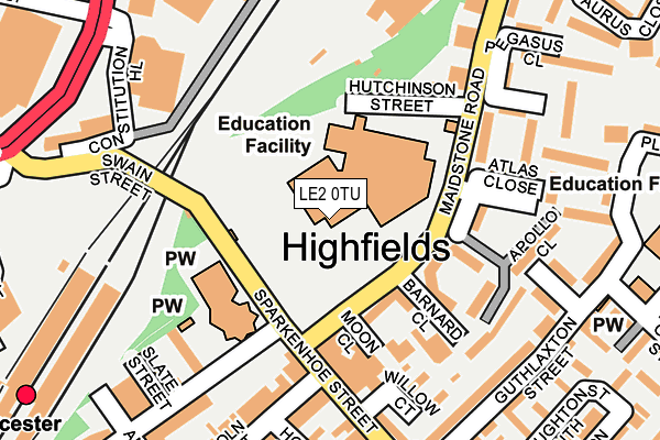
LE2 0TU is located in the Wycliffe electoral ward, within the unitary authority of Leicester and the English Parliamentary constituency of Leicester South. The Sub Integrated Care Board (ICB) Location is NHS Leicester, Leicestershire and Rutland ICB - 04C and the police force is Leicestershire. This postcode has been in use since June 1981.


GetTheData
Source: OS OpenMap – Local (Ordnance Survey)
Source: OS VectorMap District (Ordnance Survey)
Licence: Open Government Licence (requires attribution)
| Easting | 459681 |
| Northing | 304318 |
| Latitude | 52.633360 |
| Longitude | -1.119599 |
GetTheData
Source: Open Postcode Geo
Licence: Open Government Licence
| Country | England |
| Postcode District | LE2 |
➜ See where LE2 is on a map ➜ Where is Leicester? | |
GetTheData
Source: Land Registry Price Paid Data
Licence: Open Government Licence
Elevation or altitude of LE2 0TU as distance above sea level:
| Metres | Feet | |
|---|---|---|
| Elevation | 70m | 230ft |
Elevation is measured from the approximate centre of the postcode, to the nearest point on an OS contour line from OS Terrain 50, which has contour spacing of ten vertical metres.
➜ How high above sea level am I? Find the elevation of your current position using your device's GPS.
GetTheData
Source: Open Postcode Elevation
Licence: Open Government Licence
| Ward | Wycliffe |
| Constituency | Leicester South |
GetTheData
Source: ONS Postcode Database
Licence: Open Government Licence
| Lincoln Street (Sparkenhoe Street) | Highfields | 194m |
| Lincoln Street (Sparkenhoe Street) | Highfields | 213m |
| Leicester Mercury (St George's Way) | Leicester | 364m |
| Duffield Street (Melbourne Road) | Highfields | 402m |
| Highfield Street (Sparkenhoe Street) | Highfields | 415m |
| Leicester Station | 0.4km |
GetTheData
Source: NaPTAN
Licence: Open Government Licence
Estimated total energy consumption in LE2 0TU by fuel type, 2015.
| Consumption (kWh) | 75,903 |
|---|---|
| Meter count | 27 |
| Mean (kWh/meter) | 2,811 |
| Median (kWh/meter) | 2,495 |
GetTheData
Source: Postcode level gas estimates: 2015 (experimental)
Source: Postcode level electricity estimates: 2015 (experimental)
Licence: Open Government Licence
GetTheData
Source: ONS Postcode Database
Licence: Open Government Licence


➜ Get more ratings from the Food Standards Agency
GetTheData
Source: Food Standards Agency
Licence: FSA terms & conditions
| Last Collection | |||
|---|---|---|---|
| Location | Mon-Fri | Sat | Distance |
| Sparkenhoe Street | 17:30 | 12:00 | 296m |
| Queen Street | 18:30 | 12:00 | 365m |
| Railway Station Platform 3/4 | 18:30 | 12:00 | 371m |
GetTheData
Source: Dracos
Licence: Creative Commons Attribution-ShareAlike
The below table lists the International Territorial Level (ITL) codes (formerly Nomenclature of Territorial Units for Statistics (NUTS) codes) and Local Administrative Units (LAU) codes for LE2 0TU:
| ITL 1 Code | Name |
|---|---|
| TLF | East Midlands (England) |
| ITL 2 Code | Name |
| TLF2 | Leicestershire, Rutland and Northamptonshire |
| ITL 3 Code | Name |
| TLF21 | Leicester |
| LAU 1 Code | Name |
| E06000016 | Leicester |
GetTheData
Source: ONS Postcode Directory
Licence: Open Government Licence
The below table lists the Census Output Area (OA), Lower Layer Super Output Area (LSOA), and Middle Layer Super Output Area (MSOA) for LE2 0TU:
| Code | Name | |
|---|---|---|
| OA | E00069357 | |
| LSOA | E01013746 | Leicester 018C |
| MSOA | E02002844 | Leicester 018 |
GetTheData
Source: ONS Postcode Directory
Licence: Open Government Licence
| LE2 0UA | Maidstone Road | 111m |
| LE2 0UH | Vostock Close | 148m |
| LE2 0TQ | Apollo Court | 182m |
| LE2 0UJ | Pegasus Close | 195m |
| LE2 0UX | Mercury Close | 201m |
| LE2 0SE | Guthlaxton Street | 215m |
| LE2 0UU | Pluto Close | 219m |
| LE1 1PL | Constitution Hill | 244m |
| LE2 0SF | Guthlaxton Street | 252m |
| LE2 0TA | Sparkenhoe Street | 256m |
GetTheData
Source: Open Postcode Geo; Land Registry Price Paid Data
Licence: Open Government Licence