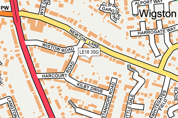
LE18 3SG lies on Cottams Close in Wigston. LE18 3SG is located in the Wigston Meadowcourt electoral ward, within the local authority district of Oadby and Wigston and the English Parliamentary constituency of Harborough. The Sub Integrated Care Board (ICB) Location is NHS Leicester, Leicestershire and Rutland ICB - 03W and the police force is Leicestershire. This postcode has been in use since March 2012.


GetTheData
Source: OS OpenMap – Local (Ordnance Survey)
Source: OS VectorMap District (Ordnance Survey)
Licence: Open Government Licence (requires attribution)
| Easting | 461131 |
| Northing | 298414 |
| Latitude | 52.580111 |
| Longitude | -1.099275 |
GetTheData
Source: Open Postcode Geo
Licence: Open Government Licence
| Street | Cottams Close |
| Town/City | Wigston |
| Country | England |
| Postcode District | LE18 |
➜ See where LE18 is on a map ➜ Where is Wigston? | |
GetTheData
Source: Land Registry Price Paid Data
Licence: Open Government Licence
Elevation or altitude of LE18 3SG as distance above sea level:
| Metres | Feet | |
|---|---|---|
| Elevation | 100m | 328ft |
Elevation is measured from the approximate centre of the postcode, to the nearest point on an OS contour line from OS Terrain 50, which has contour spacing of ten vertical metres.
➜ How high above sea level am I? Find the elevation of your current position using your device's GPS.
GetTheData
Source: Open Postcode Elevation
Licence: Open Government Licence
| Ward | Wigston Meadowcourt |
| Constituency | Harborough |
GetTheData
Source: ONS Postcode Database
Licence: Open Government Licence
| Harcourt Road (Newton Lane) | Wigston Magna | 64m |
| Harcourt Road (Newton Lane) | Wigston Magna | 144m |
| Homestead Drive (Welford Road) | Wigston Magna | 248m |
| Glaisdale Road (Meadow Way) | Wigston Magna | 324m |
| Horse & Trumpet (Bull Head Street) | Wigston Magna | 326m |
| South Wigston Station | 2.4km |
GetTheData
Source: NaPTAN
Licence: Open Government Licence
| Percentage of properties with Next Generation Access | 100.0% |
| Percentage of properties with Superfast Broadband | 100.0% |
| Percentage of properties with Ultrafast Broadband | 0.0% |
| Percentage of properties with Full Fibre Broadband | 0.0% |
Superfast Broadband is between 30Mbps and 300Mbps
Ultrafast Broadband is > 300Mbps
| Median download speed | 38.9Mbps |
| Average download speed | 32.3Mbps |
| Maximum download speed | 58.01Mbps |
| Median upload speed | 7.5Mbps |
| Average upload speed | 6.9Mbps |
| Maximum upload speed | 17.06Mbps |
| Percentage of properties unable to receive 2Mbps | 0.0% |
| Percentage of properties unable to receive 5Mbps | 0.0% |
| Percentage of properties unable to receive 10Mbps | 0.0% |
| Percentage of properties unable to receive 30Mbps | 0.0% |
GetTheData
Source: Ofcom
Licence: Ofcom Terms of Use (requires attribution)
Estimated total energy consumption in LE18 3SG by fuel type, 2015.
| Consumption (kWh) | 124,967 |
|---|---|
| Meter count | 23 |
| Mean (kWh/meter) | 5,433 |
| Median (kWh/meter) | 5,347 |
| Consumption (kWh) | 33,800 |
|---|---|
| Meter count | 23 |
| Mean (kWh/meter) | 1,470 |
| Median (kWh/meter) | 1,313 |
GetTheData
Source: Postcode level gas estimates: 2015 (experimental)
Source: Postcode level electricity estimates: 2015 (experimental)
Licence: Open Government Licence
GetTheData
Source: ONS Postcode Database
Licence: Open Government Licence


➜ Get more ratings from the Food Standards Agency
GetTheData
Source: Food Standards Agency
Licence: FSA terms & conditions
| Last Collection | |||
|---|---|---|---|
| Location | Mon-Fri | Sat | Distance |
| Homestead Drive | 17:30 | 11:30 | 278m |
| Welford Road | 17:30 | 11:30 | 538m |
| Davenport Road | 17:30 | 11:30 | 621m |
GetTheData
Source: Dracos
Licence: Creative Commons Attribution-ShareAlike
The below table lists the International Territorial Level (ITL) codes (formerly Nomenclature of Territorial Units for Statistics (NUTS) codes) and Local Administrative Units (LAU) codes for LE18 3SG:
| ITL 1 Code | Name |
|---|---|
| TLF | East Midlands (England) |
| ITL 2 Code | Name |
| TLF2 | Leicestershire, Rutland and Northamptonshire |
| ITL 3 Code | Name |
| TLF22 | Leicestershire CC and Rutland |
| LAU 1 Code | Name |
| E07000135 | Oadby and Wigston |
GetTheData
Source: ONS Postcode Directory
Licence: Open Government Licence
The below table lists the Census Output Area (OA), Lower Layer Super Output Area (LSOA), and Middle Layer Super Output Area (MSOA) for LE18 3SG:
| Code | Name | |
|---|---|---|
| OA | E00131930 | |
| LSOA | E01026001 | Oadby and Wigston 007F |
| MSOA | E02005416 | Oadby and Wigston 007 |
GetTheData
Source: ONS Postcode Directory
Licence: Open Government Licence
| LE18 3SB | Harcourt Road | 89m |
| LE18 3SF | Newton Lane | 90m |
| LE18 3SR | Kilby Drive | 110m |
| LE18 3SQ | Wistow Road | 128m |
| LE18 3UN | Clipstone Gardens | 144m |
| LE18 3SX | Windmill Bank | 146m |
| LE18 3SE | Newton Lane | 160m |
| LE18 3SJ | Stanhope Road | 162m |
| LE18 3LF | Little Dale | 174m |
| LE18 3SN | Welford Road | 205m |
GetTheData
Source: Open Postcode Geo; Land Registry Price Paid Data
Licence: Open Government Licence