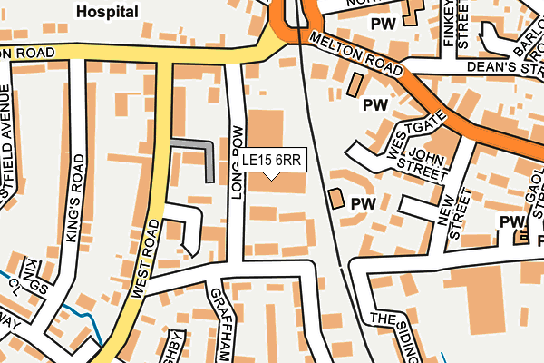
LE15 6RR is located in the Oakham North West electoral ward, within the unitary authority of Rutland and the English Parliamentary constituency of Rutland and Melton. The Sub Integrated Care Board (ICB) Location is NHS Leicester, Leicestershire and Rutland ICB - 03W and the police force is Leicestershire. This postcode has been in use since November 2008.


GetTheData
Source: OS OpenMap – Local (Ordnance Survey)
Source: OS VectorMap District (Ordnance Survey)
Licence: Open Government Licence (requires attribution)
| Easting | 485659 |
| Northing | 308743 |
| Latitude | 52.669658 |
| Longitude | -0.734693 |
GetTheData
Source: Open Postcode Geo
Licence: Open Government Licence
| Country | England |
| Postcode District | LE15 |
➜ See where LE15 is on a map ➜ Where is Oakham? | |
GetTheData
Source: Land Registry Price Paid Data
Licence: Open Government Licence
Elevation or altitude of LE15 6RR as distance above sea level:
| Metres | Feet | |
|---|---|---|
| Elevation | 110m | 361ft |
Elevation is measured from the approximate centre of the postcode, to the nearest point on an OS contour line from OS Terrain 50, which has contour spacing of ten vertical metres.
➜ How high above sea level am I? Find the elevation of your current position using your device's GPS.
GetTheData
Source: Open Postcode Elevation
Licence: Open Government Licence
| Ward | Oakham North West |
| Constituency | Rutland And Melton |
GetTheData
Source: ONS Postcode Database
Licence: Open Government Licence
| Bus Station (John Street) | Oakham | 185m |
| Tesco (South Street) | Oakham | 206m |
| Memorial Hospital (Cold Overton Road) | Oakham | 206m |
| Rail Station (Barleythorpe Road) | Oakham | 239m |
| Rail Station (Station Road) | Oakham | 258m |
| Oakham Station | 0.3km |
GetTheData
Source: NaPTAN
Licence: Open Government Licence
GetTheData
Source: ONS Postcode Database
Licence: Open Government Licence


➜ Get more ratings from the Food Standards Agency
GetTheData
Source: Food Standards Agency
Licence: FSA terms & conditions
| Last Collection | |||
|---|---|---|---|
| Location | Mon-Fri | Sat | Distance |
| West End Post Office | 17:30 | 11:30 | 140m |
| High Street | 17:30 | 11:00 | 234m |
| Westfield Avenue | 17:30 | 11:00 | 337m |
GetTheData
Source: Dracos
Licence: Creative Commons Attribution-ShareAlike
The below table lists the International Territorial Level (ITL) codes (formerly Nomenclature of Territorial Units for Statistics (NUTS) codes) and Local Administrative Units (LAU) codes for LE15 6RR:
| ITL 1 Code | Name |
|---|---|
| TLF | East Midlands (England) |
| ITL 2 Code | Name |
| TLF2 | Leicestershire, Rutland and Northamptonshire |
| ITL 3 Code | Name |
| TLF22 | Leicestershire CC and Rutland |
| LAU 1 Code | Name |
| E06000017 | Rutland |
GetTheData
Source: ONS Postcode Directory
Licence: Open Government Licence
The below table lists the Census Output Area (OA), Lower Layer Super Output Area (LSOA), and Middle Layer Super Output Area (MSOA) for LE15 6RR:
| Code | Name | |
|---|---|---|
| OA | E00069613 | |
| LSOA | E01013801 | Rutland 002C |
| MSOA | E02002864 | Rutland 002 |
GetTheData
Source: ONS Postcode Directory
Licence: Open Government Licence
| LE15 6LG | Braunston Road | 67m |
| LE15 6LN | Long Row | 70m |
| LE15 6AZ | St Annes Close | 99m |
| LE15 6LU | West Road | 107m |
| LE15 6LD | Braunston Road | 111m |
| LE15 6BP | William Dalby Walk | 125m |
| LE15 6LT | West Road | 140m |
| LE15 6AY | Melton Road | 143m |
| LE15 6AD | Cunnington Close | 143m |
| LE15 6BD | White Lion Gardens | 147m |
GetTheData
Source: Open Postcode Geo; Land Registry Price Paid Data
Licence: Open Government Licence