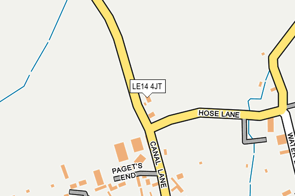
LE14 4JT is located in the Long Clawson and Stathern electoral ward, within the local authority district of Melton and the English Parliamentary constituency of Rutland and Melton. The Sub Integrated Care Board (ICB) Location is NHS Leicester, Leicestershire and Rutland ICB - 03W and the police force is Leicestershire. This postcode has been in use since April 2012.


GetTheData
Source: OS OpenMap – Local (Ordnance Survey)
Source: OS VectorMap District (Ordnance Survey)
Licence: Open Government Licence (requires attribution)
| Easting | 472934 |
| Northing | 327747 |
| Latitude | 52.842304 |
| Longitude | -0.918622 |
GetTheData
Source: Open Postcode Geo
Licence: Open Government Licence
| Country | England |
| Postcode District | LE14 |
➜ See where LE14 is on a map ➜ Where is Long Clawson? | |
GetTheData
Source: Land Registry Price Paid Data
Licence: Open Government Licence
Elevation or altitude of LE14 4JT as distance above sea level:
| Metres | Feet | |
|---|---|---|
| Elevation | 60m | 197ft |
Elevation is measured from the approximate centre of the postcode, to the nearest point on an OS contour line from OS Terrain 50, which has contour spacing of ten vertical metres.
➜ How high above sea level am I? Find the elevation of your current position using your device's GPS.
GetTheData
Source: Open Postcode Elevation
Licence: Open Government Licence
| Ward | Long Clawson And Stathern |
| Constituency | Rutland And Melton |
GetTheData
Source: ONS Postcode Database
Licence: Open Government Licence
| Surgery (The Sands) | Long Clawson | 481m |
| Surgery (East End) | Long Clawson | 516m |
| Sand Pit Lane (Back Lane) | Long Clawson | 875m |
| Hickling Lane (West End) | Long Clawson | 1,331m |
| Hickling Lane (West End) | Long Clawson | 1,334m |
GetTheData
Source: NaPTAN
Licence: Open Government Licence
| Percentage of properties with Next Generation Access | 100.0% |
| Percentage of properties with Superfast Broadband | 0.0% |
| Percentage of properties with Ultrafast Broadband | 0.0% |
| Percentage of properties with Full Fibre Broadband | 0.0% |
Superfast Broadband is between 30Mbps and 300Mbps
Ultrafast Broadband is > 300Mbps
| Percentage of properties unable to receive 2Mbps | 0.0% |
| Percentage of properties unable to receive 5Mbps | 100.0% |
| Percentage of properties unable to receive 10Mbps | 100.0% |
| Percentage of properties unable to receive 30Mbps | 100.0% |
GetTheData
Source: Ofcom
Licence: Ofcom Terms of Use (requires attribution)
GetTheData
Source: ONS Postcode Database
Licence: Open Government Licence


➜ Get more ratings from the Food Standards Agency
GetTheData
Source: Food Standards Agency
Licence: FSA terms & conditions
| Last Collection | |||
|---|---|---|---|
| Location | Mon-Fri | Sat | Distance |
| East End | 16:15 | 09:00 | 205m |
| The Sands | 16:15 | 10:10 | 508m |
| Sandpit Lane | 16:15 | 08:00 | 906m |
GetTheData
Source: Dracos
Licence: Creative Commons Attribution-ShareAlike
The below table lists the International Territorial Level (ITL) codes (formerly Nomenclature of Territorial Units for Statistics (NUTS) codes) and Local Administrative Units (LAU) codes for LE14 4JT:
| ITL 1 Code | Name |
|---|---|
| TLF | East Midlands (England) |
| ITL 2 Code | Name |
| TLF2 | Leicestershire, Rutland and Northamptonshire |
| ITL 3 Code | Name |
| TLF22 | Leicestershire CC and Rutland |
| LAU 1 Code | Name |
| E07000133 | Melton |
GetTheData
Source: ONS Postcode Directory
Licence: Open Government Licence
The below table lists the Census Output Area (OA), Lower Layer Super Output Area (LSOA), and Middle Layer Super Output Area (MSOA) for LE14 4JT:
| Code | Name | |
|---|---|---|
| OA | E00131383 | |
| LSOA | E01025891 | Melton 001E |
| MSOA | E02005391 | Melton 001 |
GetTheData
Source: ONS Postcode Directory
Licence: Open Government Licence
| LE14 4NL | Pagets End | 183m |
| LE14 4NQ | Hose Lane | 260m |
| LE14 4NG | East End | 287m |
| LE14 4PD | Water Lane | 344m |
| LE14 4PA | The Sands | 495m |
| LE14 4NU | Mill Lane | 527m |
| LE14 4NA | Back Lane | 612m |
| LE14 4PB | School Lane | 657m |
| LE14 4PL | Barkers Field | 746m |
| LE14 4ND | Church Lane | 751m |
GetTheData
Source: Open Postcode Geo; Land Registry Price Paid Data
Licence: Open Government Licence