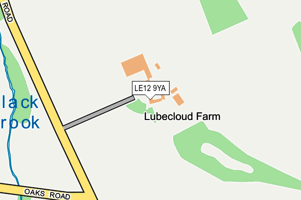
LE12 9YA is located in the Shepshed East electoral ward, within the local authority district of Charnwood and the English Parliamentary constituency of Loughborough. The Sub Integrated Care Board (ICB) Location is NHS Leicester, Leicestershire and Rutland ICB - 04V and the police force is Leicestershire. This postcode has been in use since January 1980.


GetTheData
Source: OS OpenMap – Local (Ordnance Survey)
Source: OS VectorMap District (Ordnance Survey)
Licence: Open Government Licence (requires attribution)
| Easting | 447768 |
| Northing | 316365 |
| Latitude | 52.742808 |
| Longitude | -1.293870 |
GetTheData
Source: Open Postcode Geo
Licence: Open Government Licence
| Country | England |
| Postcode District | LE12 |
➜ See where LE12 is on a map | |
GetTheData
Source: Land Registry Price Paid Data
Licence: Open Government Licence
Elevation or altitude of LE12 9YA as distance above sea level:
| Metres | Feet | |
|---|---|---|
| Elevation | 150m | 492ft |
Elevation is measured from the approximate centre of the postcode, to the nearest point on an OS contour line from OS Terrain 50, which has contour spacing of ten vertical metres.
➜ How high above sea level am I? Find the elevation of your current position using your device's GPS.
GetTheData
Source: Open Postcode Elevation
Licence: Open Government Licence
| Ward | Shepshed East |
| Constituency | Loughborough |
GetTheData
Source: ONS Postcode Database
Licence: Open Government Licence
GetTheData
Source: ONS Postcode Database
Licence: Open Government Licence


➜ Get more ratings from the Food Standards Agency
GetTheData
Source: Food Standards Agency
Licence: FSA terms & conditions
| Last Collection | |||
|---|---|---|---|
| Location | Mon-Fri | Sat | Distance |
| Leicester Road | 17:30 | 09:30 | 2,318m |
| Blackbrook A512 | 16:30 | 09:30 | 2,648m |
| Charnwood Road Post Office | 17:30 | 09:45 | 2,731m |
GetTheData
Source: Dracos
Licence: Creative Commons Attribution-ShareAlike
The below table lists the International Territorial Level (ITL) codes (formerly Nomenclature of Territorial Units for Statistics (NUTS) codes) and Local Administrative Units (LAU) codes for LE12 9YA:
| ITL 1 Code | Name |
|---|---|
| TLF | East Midlands (England) |
| ITL 2 Code | Name |
| TLF2 | Leicestershire, Rutland and Northamptonshire |
| ITL 3 Code | Name |
| TLF22 | Leicestershire CC and Rutland |
| LAU 1 Code | Name |
| E07000130 | Charnwood |
GetTheData
Source: ONS Postcode Directory
Licence: Open Government Licence
The below table lists the Census Output Area (OA), Lower Layer Super Output Area (LSOA), and Middle Layer Super Output Area (MSOA) for LE12 9YA:
| Code | Name | |
|---|---|---|
| OA | E00130597 | |
| LSOA | E01025740 | Charnwood 006A |
| MSOA | E02005350 | Charnwood 006 |
GetTheData
Source: ONS Postcode Directory
Licence: Open Government Licence
| LE12 9YD | Oaks Road | 425m |
| LE12 9YB | Charley Road | 1132m |
| LE67 4UA | Abbey Road | 1193m |
| LE12 9FG | The Pastures | 1408m |
| LE12 9FE | Iveshead Lane | 1433m |
| LE12 9ET | Jolly Farmers Lane | 1525m |
| LE12 9FP | Belfry Place | 1528m |
| LE12 9ER | Iveshead Road | 1644m |
| LE12 9EP | Iveshead Road | 1657m |
| LE12 9EU | Morley Lane | 1660m |
GetTheData
Source: Open Postcode Geo; Land Registry Price Paid Data
Licence: Open Government Licence