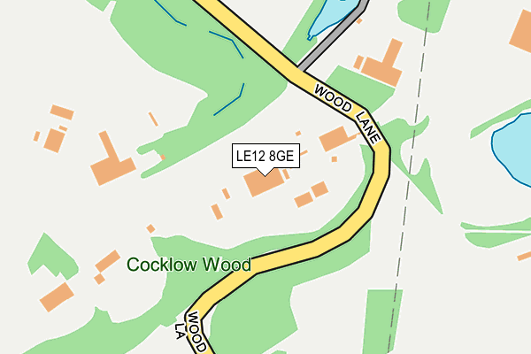
LE12 8GE is located in the Quorn & Mountsorrel Castle electoral ward, within the local authority district of Charnwood and the English Parliamentary constituency of Loughborough. The Sub Integrated Care Board (ICB) Location is NHS Leicester, Leicestershire and Rutland ICB - 04V and the police force is Leicestershire. This postcode has been in use since December 1999.


GetTheData
Source: OS OpenMap – Local (Ordnance Survey)
Source: OS VectorMap District (Ordnance Survey)
Licence: Open Government Licence (requires attribution)
| Easting | 456978 |
| Northing | 315137 |
| Latitude | 52.730880 |
| Longitude | -1.157673 |
GetTheData
Source: Open Postcode Geo
Licence: Open Government Licence
| Country | England |
| Postcode District | LE12 |
➜ See where LE12 is on a map | |
GetTheData
Source: Land Registry Price Paid Data
Licence: Open Government Licence
Elevation or altitude of LE12 8GE as distance above sea level:
| Metres | Feet | |
|---|---|---|
| Elevation | 70m | 230ft |
Elevation is measured from the approximate centre of the postcode, to the nearest point on an OS contour line from OS Terrain 50, which has contour spacing of ten vertical metres.
➜ How high above sea level am I? Find the elevation of your current position using your device's GPS.
GetTheData
Source: Open Postcode Elevation
Licence: Open Government Licence
| Ward | Quorn & Mountsorrel Castle |
| Constituency | Loughborough |
GetTheData
Source: ONS Postcode Database
Licence: Open Government Licence
| Hawcliffe Road (Loughborough Road) | Mountsorrel | 765m |
| Hawcliffe Road (Loughborough Road) | Mountsorrel | 774m |
| Bradgate Close (Loughborough Road) | Mountsorrel | 781m |
| Bradgate Close (Loughborough Road) | Mountsorrel | 784m |
| Cemetery (Loughborough Road) | Mountsorrel | 790m |
| Barrow upon Soar Station | 2.2km |
| Sileby Station | 3.2km |
GetTheData
Source: NaPTAN
Licence: Open Government Licence
GetTheData
Source: ONS Postcode Database
Licence: Open Government Licence


➜ Get more ratings from the Food Standards Agency
GetTheData
Source: Food Standards Agency
Licence: FSA terms & conditions
| Last Collection | |||
|---|---|---|---|
| Location | Mon-Fri | Sat | Distance |
| Halstead Road | 16:45 | 10:45 | 1,090m |
| Rothley Road | 16:45 | 10:45 | 1,403m |
| Quorn Post Office | 17:00 | 11:00 | 1,614m |
GetTheData
Source: Dracos
Licence: Creative Commons Attribution-ShareAlike
The below table lists the International Territorial Level (ITL) codes (formerly Nomenclature of Territorial Units for Statistics (NUTS) codes) and Local Administrative Units (LAU) codes for LE12 8GE:
| ITL 1 Code | Name |
|---|---|
| TLF | East Midlands (England) |
| ITL 2 Code | Name |
| TLF2 | Leicestershire, Rutland and Northamptonshire |
| ITL 3 Code | Name |
| TLF22 | Leicestershire CC and Rutland |
| LAU 1 Code | Name |
| E07000130 | Charnwood |
GetTheData
Source: ONS Postcode Directory
Licence: Open Government Licence
The below table lists the Census Output Area (OA), Lower Layer Super Output Area (LSOA), and Middle Layer Super Output Area (MSOA) for LE12 8GE:
| Code | Name | |
|---|---|---|
| OA | E00130558 | |
| LSOA | E01025735 | Charnwood 012D |
| MSOA | E02005356 | Charnwood 012 |
GetTheData
Source: ONS Postcode Directory
Licence: Open Government Licence
| LE12 7AH | Hawcliffe Road | 619m |
| LE12 7AQ | Hawcliffe Road | 625m |
| LE7 7SD | Rushey Lane | 634m |
| LE12 7ED | Curlew Close | 659m |
| LE12 7DW | Peppers Close | 695m |
| LE12 7UY | Woodward Close | 732m |
| LE12 7AS | Loughborough Road | 738m |
| LE12 8BX | Unitt Road | 751m |
| LE12 7AR | Loughborough Road | 768m |
| LE7 7SB | Kinchley Lane | 770m |
GetTheData
Source: Open Postcode Geo; Land Registry Price Paid Data
Licence: Open Government Licence