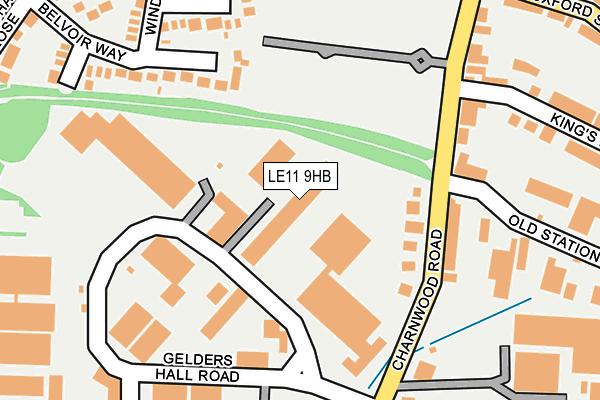
LE11 9HB is located in the Shepshed West electoral ward, within the local authority district of Charnwood and the English Parliamentary constituency of Loughborough. The Sub Integrated Care Board (ICB) Location is NHS Leicester, Leicestershire and Rutland ICB - 04V and the police force is Leicestershire. This postcode has been in use since March 2023.


GetTheData
Source: OS OpenMap – Local (Ordnance Survey)
Source: OS VectorMap District (Ordnance Survey)
Licence: Open Government Licence (requires attribution)
| Easting | 447442 |
| Northing | 318588 |
| Latitude | 52.762838 |
| Longitude | -1.298370 |
GetTheData
Source: Open Postcode Geo
Licence: Open Government Licence
| Country | England |
| Postcode District | LE11 |
➜ See where LE11 is on a map | |
GetTheData
Source: Land Registry Price Paid Data
Licence: Open Government Licence
Elevation or altitude of LE11 9HB as distance above sea level:
| Metres | Feet | |
|---|---|---|
| Elevation | 90m | 295ft |
Elevation is measured from the approximate centre of the postcode, to the nearest point on an OS contour line from OS Terrain 50, which has contour spacing of ten vertical metres.
➜ How high above sea level am I? Find the elevation of your current position using your device's GPS.
GetTheData
Source: Open Postcode Elevation
Licence: Open Government Licence
| Ward | Shepshed West |
| Constituency | Loughborough |
GetTheData
Source: ONS Postcode Database
Licence: Open Government Licence
| Old Station Close (Charnwood Road) | Shepshed | 137m |
| Old Station Close (Charnwood Road) | Shepshed | 144m |
| Anson Road (Charnwood Road) | Shepshed | 238m |
| Iveshead Road (Charnwood Road) | Shepshed | 268m |
| The Meadows | Shepshed | 320m |
GetTheData
Source: NaPTAN
Licence: Open Government Licence
GetTheData
Source: ONS Postcode Database
Licence: Open Government Licence


➜ Get more ratings from the Food Standards Agency
GetTheData
Source: Food Standards Agency
Licence: FSA terms & conditions
| Last Collection | |||
|---|---|---|---|
| Location | Mon-Fri | Sat | Distance |
| Hathern Road | 17:00 | 08:30 | 537m |
| Charnwood Road Post Office | 17:30 | 09:45 | 558m |
| Leicester Road | 17:30 | 09:30 | 745m |
GetTheData
Source: Dracos
Licence: Creative Commons Attribution-ShareAlike
The below table lists the International Territorial Level (ITL) codes (formerly Nomenclature of Territorial Units for Statistics (NUTS) codes) and Local Administrative Units (LAU) codes for LE11 9HB:
| ITL 1 Code | Name |
|---|---|
| TLF | East Midlands (England) |
| ITL 2 Code | Name |
| TLF2 | Leicestershire, Rutland and Northamptonshire |
| ITL 3 Code | Name |
| TLF22 | Leicestershire CC and Rutland |
| LAU 1 Code | Name |
| E07000130 | Charnwood |
GetTheData
Source: ONS Postcode Directory
Licence: Open Government Licence
The below table lists the Census Output Area (OA), Lower Layer Super Output Area (LSOA), and Middle Layer Super Output Area (MSOA) for LE11 9HB:
| Code | Name | |
|---|---|---|
| OA | E00130631 | |
| LSOA | E01025744 | Charnwood 005A |
| MSOA | E02005349 | Charnwood 005 |
GetTheData
Source: ONS Postcode Directory
Licence: Open Government Licence
| LE12 9NW | Charnwood Road | 155m |
| LE12 9PY | Belvoir Way | 179m |
| LE12 9QB | Caernarvon Close | 196m |
| LE12 9NR | Charnwood Road | 231m |
| LE12 9QR | Windsor Drive | 267m |
| LE12 9PS | Arundel Grove | 280m |
| LE12 9NJ | Old Station Close | 282m |
| LE12 9HT | Kings Road | 301m |
| LE12 9HU | Oxford Street | 331m |
| LE12 9PX | Balmoral Avenue | 350m |
GetTheData
Source: Open Postcode Geo; Land Registry Price Paid Data
Licence: Open Government Licence