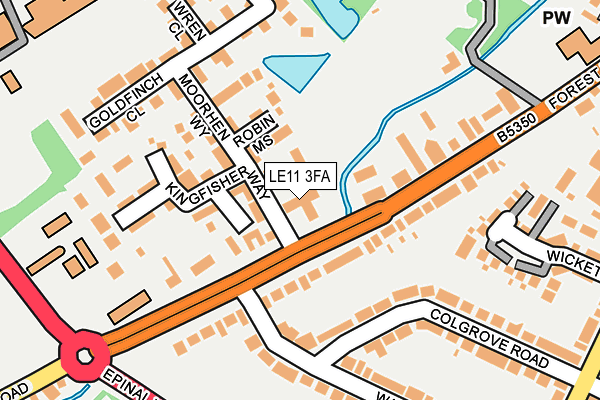
LE11 3FA is located in the Loughborough Southfields electoral ward, within the local authority district of Charnwood and the English Parliamentary constituency of Loughborough. The Sub Integrated Care Board (ICB) Location is NHS Leicester, Leicestershire and Rutland ICB - 04V and the police force is Leicestershire. This postcode has been in use since April 2014.


GetTheData
Source: OS OpenMap – Local (Ordnance Survey)
Source: OS VectorMap District (Ordnance Survey)
Licence: Open Government Licence (requires attribution)
| Easting | 453072 |
| Northing | 318960 |
| Latitude | 52.765640 |
| Longitude | -1.214892 |
GetTheData
Source: Open Postcode Geo
Licence: Open Government Licence
| Country | England |
| Postcode District | LE11 |
➜ See where LE11 is on a map ➜ Where is Loughborough? | |
GetTheData
Source: Land Registry Price Paid Data
Licence: Open Government Licence
Elevation or altitude of LE11 3FA as distance above sea level:
| Metres | Feet | |
|---|---|---|
| Elevation | 50m | 164ft |
Elevation is measured from the approximate centre of the postcode, to the nearest point on an OS contour line from OS Terrain 50, which has contour spacing of ten vertical metres.
➜ How high above sea level am I? Find the elevation of your current position using your device's GPS.
GetTheData
Source: Open Postcode Elevation
Licence: Open Government Licence
| Ward | Loughborough Southfields |
| Constituency | Loughborough |
GetTheData
Source: ONS Postcode Database
Licence: Open Government Licence
| Wallace Road (Forest Road) | Loughborough | 28m |
| Wallace Road (Forest Road) | Loughborough | 132m |
| Emmanuel Church (Forest Road) | Loughborough | 338m |
| Emmanuel Church (Forest Road) | Loughborough | 368m |
| Royland Road (Park Road) | Loughborough | 402m |
| Loughborough Central (Great Central Railway) | Loughborough | 1,327m |
| Loughborough (Leics) Station | 2km |
| Barrow upon Soar Station | 5.1km |
GetTheData
Source: NaPTAN
Licence: Open Government Licence
GetTheData
Source: ONS Postcode Database
Licence: Open Government Licence


➜ Get more ratings from the Food Standards Agency
GetTheData
Source: Food Standards Agency
Licence: FSA terms & conditions
| Last Collection | |||
|---|---|---|---|
| Location | Mon-Fri | Sat | Distance |
| Woodbrook/Forest Road | 17:30 | 12:00 | 35m |
| Herrick Road/Beacon Road | 17:30 | 10:30 | 398m |
| Derwent Drive | 17:15 | 12:00 | 419m |
GetTheData
Source: Dracos
Licence: Creative Commons Attribution-ShareAlike
The below table lists the International Territorial Level (ITL) codes (formerly Nomenclature of Territorial Units for Statistics (NUTS) codes) and Local Administrative Units (LAU) codes for LE11 3FA:
| ITL 1 Code | Name |
|---|---|
| TLF | East Midlands (England) |
| ITL 2 Code | Name |
| TLF2 | Leicestershire, Rutland and Northamptonshire |
| ITL 3 Code | Name |
| TLF22 | Leicestershire CC and Rutland |
| LAU 1 Code | Name |
| E07000130 | Charnwood |
GetTheData
Source: ONS Postcode Directory
Licence: Open Government Licence
The below table lists the Census Output Area (OA), Lower Layer Super Output Area (LSOA), and Middle Layer Super Output Area (MSOA) for LE11 3FA:
| Code | Name | |
|---|---|---|
| OA | E00173340 | |
| LSOA | E01025720 | Charnwood 003A |
| MSOA | E02005347 | Charnwood 003 |
GetTheData
Source: ONS Postcode Directory
Licence: Open Government Licence
| LE11 3NR | Forest Road | 89m |
| LE11 3HJ | Robin Mews | 93m |
| LE11 3HH | Moorhen Way | 108m |
| LE11 3NW | Forest Road | 122m |
| LE11 3NF | Kingfisher Way | 175m |
| LE11 3NL | Colgrove Road | 182m |
| LE11 3HG | Goldfinch Close | 198m |
| LE11 3HD | Adam Dale | 208m |
| LE11 3NU | Wallace Road | 213m |
| LE11 3NN | Colgrove Road | 217m |
GetTheData
Source: Open Postcode Geo; Land Registry Price Paid Data
Licence: Open Government Licence