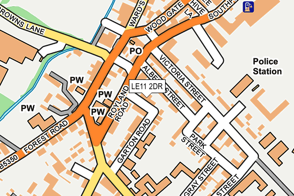
LE11 2DR lies on Bampton Street in Loughborough. LE11 2DR is located in the Loughborough Southfields electoral ward, within the local authority district of Charnwood and the English Parliamentary constituency of Loughborough. The Sub Integrated Care Board (ICB) Location is NHS Leicester, Leicestershire and Rutland ICB - 04V and the police force is Leicestershire. This postcode has been in use since January 1980.


GetTheData
Source: OS OpenMap – Local (Ordnance Survey)
Source: OS VectorMap District (Ordnance Survey)
Licence: Open Government Licence (requires attribution)
| Easting | 453572 |
| Northing | 319163 |
| Latitude | 52.767416 |
| Longitude | -1.207450 |
GetTheData
Source: Open Postcode Geo
Licence: Open Government Licence
| Street | Bampton Street |
| Town/City | Loughborough |
| Country | England |
| Postcode District | LE11 |
➜ See where LE11 is on a map ➜ Where is Loughborough? | |
GetTheData
Source: Land Registry Price Paid Data
Licence: Open Government Licence
Elevation or altitude of LE11 2DR as distance above sea level:
| Metres | Feet | |
|---|---|---|
| Elevation | 40m | 131ft |
Elevation is measured from the approximate centre of the postcode, to the nearest point on an OS contour line from OS Terrain 50, which has contour spacing of ten vertical metres.
➜ How high above sea level am I? Find the elevation of your current position using your device's GPS.
GetTheData
Source: Open Postcode Elevation
Licence: Open Government Licence
| Ward | Loughborough Southfields |
| Constituency | Loughborough |
GetTheData
Source: ONS Postcode Database
Licence: Open Government Licence
| New Street (Wards End) | Loughborough | 136m |
| Wards End (Browns Lane) | Loughborough | 149m |
| Royland Road (Park Road) | Loughborough | 153m |
| Bee Hive Lane (Southfield Road) | Loughborough | 154m |
| Emmanuel Church (Forest Road) | Loughborough | 172m |
| Loughborough Central (Great Central Railway) | Loughborough | 795m |
| Loughborough (Leics) Station | 1.5km |
| Barrow upon Soar Station | 4.7km |
GetTheData
Source: NaPTAN
Licence: Open Government Licence
| Percentage of properties with Next Generation Access | 100.0% |
| Percentage of properties with Superfast Broadband | 100.0% |
| Percentage of properties with Ultrafast Broadband | 100.0% |
| Percentage of properties with Full Fibre Broadband | 0.0% |
Superfast Broadband is between 30Mbps and 300Mbps
Ultrafast Broadband is > 300Mbps
| Median download speed | 89.1Mbps |
| Average download speed | 139.0Mbps |
| Maximum download speed | 350.00Mbps |
| Median upload speed | 19.5Mbps |
| Average upload speed | 19.5Mbps |
| Maximum upload speed | 19.53Mbps |
| Percentage of properties unable to receive 2Mbps | 0.0% |
| Percentage of properties unable to receive 5Mbps | 0.0% |
| Percentage of properties unable to receive 10Mbps | 0.0% |
| Percentage of properties unable to receive 30Mbps | 0.0% |
GetTheData
Source: Ofcom
Licence: Ofcom Terms of Use (requires attribution)
Estimated total energy consumption in LE11 2DR by fuel type, 2015.
| Consumption (kWh) | 218,754 |
|---|---|
| Meter count | 15 |
| Mean (kWh/meter) | 14,584 |
| Median (kWh/meter) | 14,309 |
| Consumption (kWh) | 48,309 |
|---|---|
| Meter count | 13 |
| Mean (kWh/meter) | 3,716 |
| Median (kWh/meter) | 2,609 |
GetTheData
Source: Postcode level gas estimates: 2015 (experimental)
Source: Postcode level electricity estimates: 2015 (experimental)
Licence: Open Government Licence
GetTheData
Source: ONS Postcode Database
Licence: Open Government Licence


➜ Get more ratings from the Food Standards Agency
GetTheData
Source: Food Standards Agency
Licence: FSA terms & conditions
| Last Collection | |||
|---|---|---|---|
| Location | Mon-Fri | Sat | Distance |
| Bedford Square | 17:30 | 12:00 | 128m |
| Park Road | 17:30 | 11:45 | 158m |
| Derwent Drive | 17:15 | 12:00 | 160m |
GetTheData
Source: Dracos
Licence: Creative Commons Attribution-ShareAlike
The below table lists the International Territorial Level (ITL) codes (formerly Nomenclature of Territorial Units for Statistics (NUTS) codes) and Local Administrative Units (LAU) codes for LE11 2DR:
| ITL 1 Code | Name |
|---|---|
| TLF | East Midlands (England) |
| ITL 2 Code | Name |
| TLF2 | Leicestershire, Rutland and Northamptonshire |
| ITL 3 Code | Name |
| TLF22 | Leicestershire CC and Rutland |
| LAU 1 Code | Name |
| E07000130 | Charnwood |
GetTheData
Source: ONS Postcode Directory
Licence: Open Government Licence
The below table lists the Census Output Area (OA), Lower Layer Super Output Area (LSOA), and Middle Layer Super Output Area (MSOA) for LE11 2DR:
| Code | Name | |
|---|---|---|
| OA | E00130495 | |
| LSOA | E01025720 | Charnwood 003A |
| MSOA | E02005347 | Charnwood 003 |
GetTheData
Source: ONS Postcode Directory
Licence: Open Government Licence
| LE11 2DW | Albert Street | 29m |
| LE11 2EH | Royland Road | 55m |
| LE11 2DY | Garton Road | 64m |
| LE11 2EN | Victoria Street | 91m |
| LE11 2DS | Bedford Street | 92m |
| LE11 2TL | Victoria Street | 104m |
| LE11 2DN | Albert Place | 114m |
| LE11 2EW | Victoria Street | 116m |
| LE11 2EQ | Princess Street | 160m |
| LE11 2EG | Park Street | 164m |
GetTheData
Source: Open Postcode Geo; Land Registry Price Paid Data
Licence: Open Government Licence