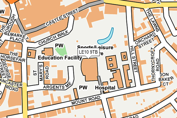
LE10 9TB is located in the Hinckley Castle electoral ward, within the local authority district of Hinckley and Bosworth and the English Parliamentary constituency of Bosworth. The Sub Integrated Care Board (ICB) Location is NHS Leicester, Leicestershire and Rutland ICB - 04V and the police force is Leicestershire. This postcode has been in use since January 2017.


GetTheData
Source: OS OpenMap – Local (Ordnance Survey)
Source: OS VectorMap District (Ordnance Survey)
Licence: Open Government Licence (requires attribution)
| Easting | 442852 |
| Northing | 293797 |
| Latitude | 52.540369 |
| Longitude | -1.369595 |
GetTheData
Source: Open Postcode Geo
Licence: Open Government Licence
| Country | England |
| Postcode District | LE10 |
➜ See where LE10 is on a map | |
GetTheData
Source: Land Registry Price Paid Data
Licence: Open Government Licence
Elevation or altitude of LE10 9TB as distance above sea level:
| Metres | Feet | |
|---|---|---|
| Elevation | 120m | 394ft |
Elevation is measured from the approximate centre of the postcode, to the nearest point on an OS contour line from OS Terrain 50, which has contour spacing of ten vertical metres.
➜ How high above sea level am I? Find the elevation of your current position using your device's GPS.
GetTheData
Source: Open Postcode Elevation
Licence: Open Government Licence
| Ward | Hinckley Castle |
| Constituency | Bosworth |
GetTheData
Source: ONS Postcode Database
Licence: Open Government Licence
| Hill Street (Castle Street) | Hinckley | 205m |
| Hill Street (Castle Street) | Hinckley | 218m |
| St Mary's Road (Station Road) | Hinckley | 259m |
| St Mary's Road (Station Road) | Hinckley | 278m |
| Regent Street (The Borough) | Hinckley | 296m |
| Hinckley Station | 0.6km |
GetTheData
Source: NaPTAN
Licence: Open Government Licence
GetTheData
Source: ONS Postcode Database
Licence: Open Government Licence


➜ Get more ratings from the Food Standards Agency
GetTheData
Source: Food Standards Agency
Licence: FSA terms & conditions
| Last Collection | |||
|---|---|---|---|
| Location | Mon-Fri | Sat | Distance |
| Castle Street | 18:30 | 11:00 | 79m |
| Mount Road | 18:30 | 11:00 | 160m |
| The Borough | 18:00 | 11:00 | 323m |
GetTheData
Source: Dracos
Licence: Creative Commons Attribution-ShareAlike
The below table lists the International Territorial Level (ITL) codes (formerly Nomenclature of Territorial Units for Statistics (NUTS) codes) and Local Administrative Units (LAU) codes for LE10 9TB:
| ITL 1 Code | Name |
|---|---|
| TLF | East Midlands (England) |
| ITL 2 Code | Name |
| TLF2 | Leicestershire, Rutland and Northamptonshire |
| ITL 3 Code | Name |
| TLF22 | Leicestershire CC and Rutland |
| LAU 1 Code | Name |
| E07000132 | Hinckley and Bosworth |
GetTheData
Source: ONS Postcode Directory
Licence: Open Government Licence
The below table lists the Census Output Area (OA), Lower Layer Super Output Area (LSOA), and Middle Layer Super Output Area (MSOA) for LE10 9TB:
| Code | Name | |
|---|---|---|
| OA | E00131173 | |
| LSOA | E01025852 | Hinckley and Bosworth 010B |
| MSOA | E02005386 | Hinckley and Bosworth 010 |
GetTheData
Source: ONS Postcode Directory
Licence: Open Government Licence
| LE10 1DS | Hill Street | 139m |
| LE10 1DA | Castle Street | 146m |
| LE10 1DT | Hill Street | 172m |
| LE10 1AF | Mount Road | 178m |
| LE10 1AD | Mount Road | 187m |
| LE10 1DB | Castle Street | 196m |
| LE10 1EH | The Narrows | 198m |
| LE10 1DZ | Orchard Street | 201m |
| LE10 1AE | Mount Road | 212m |
| LE10 1BG | Thornycroft Road | 224m |
GetTheData
Source: Open Postcode Geo; Land Registry Price Paid Data
Licence: Open Government Licence