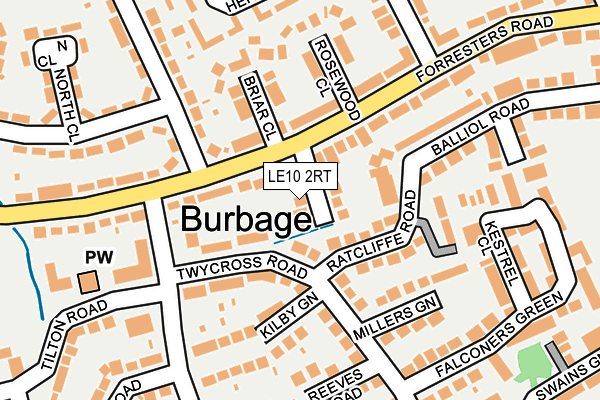
LE10 2RT lies on Forresters Close in Burbage, Hinckley. LE10 2RT is located in the Burbage St Catherines and Lash Hill electoral ward, within the local authority district of Hinckley and Bosworth and the English Parliamentary constituency of Bosworth. The Sub Integrated Care Board (ICB) Location is NHS Leicester, Leicestershire and Rutland ICB - 04V and the police force is Leicestershire. This postcode has been in use since January 1980.


GetTheData
Source: OS OpenMap – Local (Ordnance Survey)
Source: OS VectorMap District (Ordnance Survey)
Licence: Open Government Licence (requires attribution)
| Easting | 443607 |
| Northing | 292786 |
| Latitude | 52.531204 |
| Longitude | -1.358607 |
GetTheData
Source: Open Postcode Geo
Licence: Open Government Licence
| Street | Forresters Close |
| Locality | Burbage |
| Town/City | Hinckley |
| Country | England |
| Postcode District | LE10 |
➜ See where LE10 is on a map ➜ Where is Hinckley? | |
GetTheData
Source: Land Registry Price Paid Data
Licence: Open Government Licence
Elevation or altitude of LE10 2RT as distance above sea level:
| Metres | Feet | |
|---|---|---|
| Elevation | 120m | 394ft |
Elevation is measured from the approximate centre of the postcode, to the nearest point on an OS contour line from OS Terrain 50, which has contour spacing of ten vertical metres.
➜ How high above sea level am I? Find the elevation of your current position using your device's GPS.
GetTheData
Source: Open Postcode Elevation
Licence: Open Government Licence
| Ward | Burbage St Catherines And Lash Hill |
| Constituency | Bosworth |
GetTheData
Source: ONS Postcode Database
Licence: Open Government Licence
4, FORRESTERS CLOSE, BURBAGE, HINCKLEY, LE10 2RT 2022 5 AUG £425,000 |
6, FORRESTERS CLOSE, BURBAGE, HINCKLEY, LE10 2RT 2021 21 DEC £285,000 |
5, FORRESTERS CLOSE, BURBAGE, HINCKLEY, LE10 2RT 2021 10 JUN £315,000 |
2020 24 MAR £390,000 |
2016 16 AUG £202,250 |
8, FORRESTERS CLOSE, BURBAGE, HINCKLEY, LE10 2RT 1996 21 JUN £65,000 |
GetTheData
Source: HM Land Registry Price Paid Data
Licence: Contains HM Land Registry data © Crown copyright and database right 2025. This data is licensed under the Open Government Licence v3.0.
| Shops (Boyslade Road) | Burbage | 134m |
| Shops (Boyslade Road) | Burbage | 152m |
| Boyslade Road (Featherston Drive) | Burbage | 195m |
| Co-operative Store (Tilton Road) | Burbage | 201m |
| Squires Green (Twycross Road) | Burbage | 214m |
| Hinckley Station | 1km |
GetTheData
Source: NaPTAN
Licence: Open Government Licence
| Percentage of properties with Next Generation Access | 100.0% |
| Percentage of properties with Superfast Broadband | 100.0% |
| Percentage of properties with Ultrafast Broadband | 100.0% |
| Percentage of properties with Full Fibre Broadband | 0.0% |
Superfast Broadband is between 30Mbps and 300Mbps
Ultrafast Broadband is > 300Mbps
| Median download speed | 13.1Mbps |
| Average download speed | 76.7Mbps |
| Maximum download speed | 350.00Mbps |
| Median upload speed | 1.1Mbps |
| Average upload speed | 1.0Mbps |
| Maximum upload speed | 1.20Mbps |
| Percentage of properties unable to receive 2Mbps | 0.0% |
| Percentage of properties unable to receive 5Mbps | 0.0% |
| Percentage of properties unable to receive 10Mbps | 0.0% |
| Percentage of properties unable to receive 30Mbps | 0.0% |
GetTheData
Source: Ofcom
Licence: Ofcom Terms of Use (requires attribution)
Estimated total energy consumption in LE10 2RT by fuel type, 2015.
| Consumption (kWh) | 165,586 |
|---|---|
| Meter count | 8 |
| Mean (kWh/meter) | 20,698 |
| Median (kWh/meter) | 18,786 |
GetTheData
Source: Postcode level gas estimates: 2015 (experimental)
Source: Postcode level electricity estimates: 2015 (experimental)
Licence: Open Government Licence
GetTheData
Source: ONS Postcode Database
Licence: Open Government Licence


➜ Get more ratings from the Food Standards Agency
GetTheData
Source: Food Standards Agency
Licence: FSA terms & conditions
| Last Collection | |||
|---|---|---|---|
| Location | Mon-Fri | Sat | Distance |
| Boyslade Road | 17:45 | 11:00 | 158m |
| Hinckley Road | 17:45 | 11:00 | 567m |
| Sketchley Road | 17:30 | 11:00 | 577m |
GetTheData
Source: Dracos
Licence: Creative Commons Attribution-ShareAlike
The below table lists the International Territorial Level (ITL) codes (formerly Nomenclature of Territorial Units for Statistics (NUTS) codes) and Local Administrative Units (LAU) codes for LE10 2RT:
| ITL 1 Code | Name |
|---|---|
| TLF | East Midlands (England) |
| ITL 2 Code | Name |
| TLF2 | Leicestershire, Rutland and Northamptonshire |
| ITL 3 Code | Name |
| TLF22 | Leicestershire CC and Rutland |
| LAU 1 Code | Name |
| E07000132 | Hinckley and Bosworth |
GetTheData
Source: ONS Postcode Directory
Licence: Open Government Licence
The below table lists the Census Output Area (OA), Lower Layer Super Output Area (LSOA), and Middle Layer Super Output Area (MSOA) for LE10 2RT:
| Code | Name | |
|---|---|---|
| OA | E00131057 | |
| LSOA | E01025830 | Hinckley and Bosworth 013D |
| MSOA | E02005389 | Hinckley and Bosworth 013 |
GetTheData
Source: ONS Postcode Directory
Licence: Open Government Licence
| LE10 2SP | Ratcliffe Road | 123m |
| LE10 2RH | Briar Close | 126m |
| LE10 2SN | Kilby Green | 139m |
| LE10 2SA | Rosewood Close | 145m |
| LE10 2ST | Millers Green | 146m |
| LE10 2SF | Twycross Road | 162m |
| LE10 2SG | Twycross Road | 169m |
| LE10 2RP | Edale Green | 180m |
| LE10 2PA | Kestrel Close | 196m |
| LE10 2RE | Balliol Road | 200m |
GetTheData
Source: Open Postcode Geo; Land Registry Price Paid Data
Licence: Open Government Licence