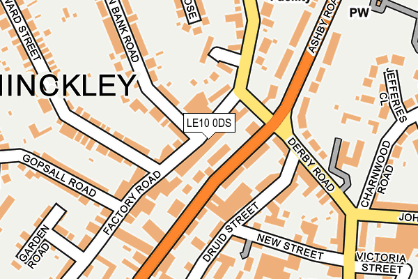
LE10 0DS lies on Factory Road in Hinckley. LE10 0DS is located in the Hinckley De Montfort electoral ward, within the local authority district of Hinckley and Bosworth and the English Parliamentary constituency of Bosworth. The Sub Integrated Care Board (ICB) Location is NHS Leicester, Leicestershire and Rutland ICB - 04V and the police force is Leicestershire. This postcode has been in use since January 1980.


GetTheData
Source: OS OpenMap – Local (Ordnance Survey)
Source: OS VectorMap District (Ordnance Survey)
Licence: Open Government Licence (requires attribution)
| Easting | 442752 |
| Northing | 294570 |
| Latitude | 52.547308 |
| Longitude | -1.370981 |
GetTheData
Source: Open Postcode Geo
Licence: Open Government Licence
| Street | Factory Road |
| Town/City | Hinckley |
| Country | England |
| Postcode District | LE10 |
➜ See where LE10 is on a map ➜ Where is Hinckley? | |
GetTheData
Source: Land Registry Price Paid Data
Licence: Open Government Licence
Elevation or altitude of LE10 0DS as distance above sea level:
| Metres | Feet | |
|---|---|---|
| Elevation | 130m | 427ft |
Elevation is measured from the approximate centre of the postcode, to the nearest point on an OS contour line from OS Terrain 50, which has contour spacing of ten vertical metres.
➜ How high above sea level am I? Find the elevation of your current position using your device's GPS.
GetTheData
Source: Open Postcode Elevation
Licence: Open Government Licence
| Ward | Hinckley De Montfort |
| Constituency | Bosworth |
GetTheData
Source: ONS Postcode Database
Licence: Open Government Licence
| Factory Road (Ashby Road) | Hinckley | 146m |
| Factory Road (Ashby Road) | Hinckley | 190m |
| Well Lane (Upper Bond Street) | Hinckley | 243m |
| New Street (Derby Road) | Hinckley | 246m |
| Well Lane (Upper Bond Street) | Hinckley | 272m |
| Hinckley Station | 1.4km |
GetTheData
Source: NaPTAN
Licence: Open Government Licence
| Percentage of properties with Next Generation Access | 100.0% |
| Percentage of properties with Superfast Broadband | 100.0% |
| Percentage of properties with Ultrafast Broadband | 94.6% |
| Percentage of properties with Full Fibre Broadband | 0.0% |
Superfast Broadband is between 30Mbps and 300Mbps
Ultrafast Broadband is > 300Mbps
| Median download speed | 75.1Mbps |
| Average download speed | 78.3Mbps |
| Maximum download speed | 350.00Mbps |
| Median upload speed | 2.5Mbps |
| Average upload speed | 7.0Mbps |
| Maximum upload speed | 20.00Mbps |
| Percentage of properties unable to receive 2Mbps | 0.0% |
| Percentage of properties unable to receive 5Mbps | 0.0% |
| Percentage of properties unable to receive 10Mbps | 0.0% |
| Percentage of properties unable to receive 30Mbps | 0.0% |
GetTheData
Source: Ofcom
Licence: Ofcom Terms of Use (requires attribution)
Estimated total energy consumption in LE10 0DS by fuel type, 2015.
| Consumption (kWh) | 280,452 |
|---|---|
| Meter count | 32 |
| Mean (kWh/meter) | 8,764 |
| Median (kWh/meter) | 6,637 |
| Consumption (kWh) | 112,226 |
|---|---|
| Meter count | 38 |
| Mean (kWh/meter) | 2,953 |
| Median (kWh/meter) | 2,145 |
GetTheData
Source: Postcode level gas estimates: 2015 (experimental)
Source: Postcode level electricity estimates: 2015 (experimental)
Licence: Open Government Licence
GetTheData
Source: ONS Postcode Database
Licence: Open Government Licence


➜ Get more ratings from the Food Standards Agency
GetTheData
Source: Food Standards Agency
Licence: FSA terms & conditions
| Last Collection | |||
|---|---|---|---|
| Location | Mon-Fri | Sat | Distance |
| Lower Bond Street | 18:30 | 11:00 | 360m |
| Derby Road Post Office | 18:00 | 11:00 | 374m |
| Stanley Road | 17:30 | 11:00 | 432m |
GetTheData
Source: Dracos
Licence: Creative Commons Attribution-ShareAlike
The below table lists the International Territorial Level (ITL) codes (formerly Nomenclature of Territorial Units for Statistics (NUTS) codes) and Local Administrative Units (LAU) codes for LE10 0DS:
| ITL 1 Code | Name |
|---|---|
| TLF | East Midlands (England) |
| ITL 2 Code | Name |
| TLF2 | Leicestershire, Rutland and Northamptonshire |
| ITL 3 Code | Name |
| TLF22 | Leicestershire CC and Rutland |
| LAU 1 Code | Name |
| E07000132 | Hinckley and Bosworth |
GetTheData
Source: ONS Postcode Directory
Licence: Open Government Licence
The below table lists the Census Output Area (OA), Lower Layer Super Output Area (LSOA), and Middle Layer Super Output Area (MSOA) for LE10 0DS:
| Code | Name | |
|---|---|---|
| OA | E00131240 | |
| LSOA | E01025863 | Hinckley and Bosworth 010D |
| MSOA | E02005386 | Hinckley and Bosworth 010 |
GetTheData
Source: ONS Postcode Directory
Licence: Open Government Licence
| LE10 0DP | Factory Road | 37m |
| LE10 1RT | Upper Bond Street | 60m |
| LE10 1QQ | Druid Street | 105m |
| LE10 0QT | Middlefield Court | 112m |
| LE10 1SP | Ashby Road | 117m |
| LE10 1QE | Derby Road | 177m |
| LE10 1QY | New Street | 185m |
| LE10 1QZ | New Street | 191m |
| LE10 0DL | Edward Street | 192m |
| LE10 0DH | Edward Street | 218m |
GetTheData
Source: Open Postcode Geo; Land Registry Price Paid Data
Licence: Open Government Licence