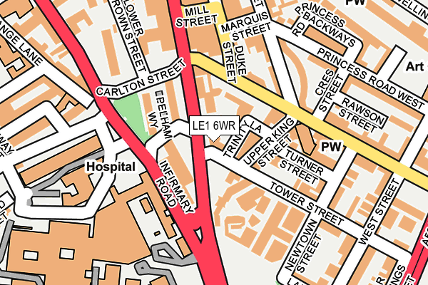
LE1 6WR lies on Tower Street in Leicester. LE1 6WR is located in the Castle electoral ward, within the unitary authority of Leicester and the English Parliamentary constituency of Leicester South. The Sub Integrated Care Board (ICB) Location is NHS Leicester, Leicestershire and Rutland ICB - 04C and the police force is Leicestershire. This postcode has been in use since January 1980.


GetTheData
Source: OS OpenMap – Local (Ordnance Survey)
Source: OS VectorMap District (Ordnance Survey)
Licence: Open Government Licence (requires attribution)
| Easting | 458802 |
| Northing | 303757 |
| Latitude | 52.628394 |
| Longitude | -1.132693 |
GetTheData
Source: Open Postcode Geo
Licence: Open Government Licence
| Street | Tower Street |
| Town/City | Leicester |
| Country | England |
| Postcode District | LE1 |
➜ See where LE1 is on a map ➜ Where is Leicester? | |
GetTheData
Source: Land Registry Price Paid Data
Licence: Open Government Licence
Elevation or altitude of LE1 6WR as distance above sea level:
| Metres | Feet | |
|---|---|---|
| Elevation | 60m | 197ft |
Elevation is measured from the approximate centre of the postcode, to the nearest point on an OS contour line from OS Terrain 50, which has contour spacing of ten vertical metres.
➜ How high above sea level am I? Find the elevation of your current position using your device's GPS.
GetTheData
Source: Open Postcode Elevation
Licence: Open Government Licence
| Ward | Castle |
| Constituency | Leicester South |
GetTheData
Source: ONS Postcode Database
Licence: Open Government Licence
| Regent Road (Welford Road) | Leicester | 39m |
| Regent Road (Welford Road) | Leicester | 59m |
| Regent Road (Welford Road) | Leicester | 86m |
| Royal Infirmary Hospital (Infirmary Road) | Leicester | 105m |
| Royal Infirmary Hospital (Infirmary Road) | Leicester | 113m |
| Leicester Station | 0.6km |
GetTheData
Source: NaPTAN
Licence: Open Government Licence
| Percentage of properties with Next Generation Access | 100.0% |
| Percentage of properties with Superfast Broadband | 100.0% |
| Percentage of properties with Ultrafast Broadband | 100.0% |
| Percentage of properties with Full Fibre Broadband | 0.0% |
Superfast Broadband is between 30Mbps and 300Mbps
Ultrafast Broadband is > 300Mbps
| Percentage of properties unable to receive 2Mbps | 0.0% |
| Percentage of properties unable to receive 5Mbps | 0.0% |
| Percentage of properties unable to receive 10Mbps | 0.0% |
| Percentage of properties unable to receive 30Mbps | 0.0% |
GetTheData
Source: Ofcom
Licence: Ofcom Terms of Use (requires attribution)
GetTheData
Source: ONS Postcode Database
Licence: Open Government Licence


➜ Get more ratings from the Food Standards Agency
GetTheData
Source: Food Standards Agency
Licence: FSA terms & conditions
| Last Collection | |||
|---|---|---|---|
| Location | Mon-Fri | Sat | Distance |
| King Street | 18:30 | 12:00 | 161m |
| Welford Place | 18:30 | 12:00 | 216m |
| Wellington Street | 18:30 | 12:00 | 329m |
GetTheData
Source: Dracos
Licence: Creative Commons Attribution-ShareAlike
The below table lists the International Territorial Level (ITL) codes (formerly Nomenclature of Territorial Units for Statistics (NUTS) codes) and Local Administrative Units (LAU) codes for LE1 6WR:
| ITL 1 Code | Name |
|---|---|
| TLF | East Midlands (England) |
| ITL 2 Code | Name |
| TLF2 | Leicestershire, Rutland and Northamptonshire |
| ITL 3 Code | Name |
| TLF21 | Leicester |
| LAU 1 Code | Name |
| E06000016 | Leicester |
GetTheData
Source: ONS Postcode Directory
Licence: Open Government Licence
The below table lists the Census Output Area (OA), Lower Layer Super Output Area (LSOA), and Middle Layer Super Output Area (MSOA) for LE1 6WR:
| Code | Name | |
|---|---|---|
| OA | E00068911 | |
| LSOA | E01013647 | Leicester 040B |
| MSOA | E02006850 | Leicester 040 |
GetTheData
Source: ONS Postcode Directory
Licence: Open Government Licence
| LE2 7AB | Welford Road | 50m |
| LE1 6XF | Upper King Street | 68m |
| LE1 6XE | Upper King Street | 94m |
| LE1 6WS | Tower Street | 129m |
| LE1 6WA | Duke Street | 136m |
| LE1 6RP | King Street | 139m |
| LE1 6WY | Turner Street | 140m |
| LE1 6RS | Marquis Street | 162m |
| LE1 6YJ | Regent Road | 174m |
| LE1 6WJ | Newtown Street | 189m |
GetTheData
Source: Open Postcode Geo; Land Registry Price Paid Data
Licence: Open Government Licence