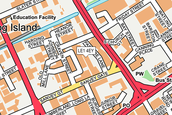
LE1 4EY lies on Pasture Lane in Leicester. LE1 4EY is located in the Abbey electoral ward, within the unitary authority of Leicester and the English Parliamentary constituency of Leicester West. The Sub Integrated Care Board (ICB) Location is NHS Leicester, Leicestershire and Rutland ICB - 04C and the police force is Leicestershire. This postcode has been in use since January 1980.


GetTheData
Source: OS OpenMap – Local (Ordnance Survey)
Source: OS VectorMap District (Ordnance Survey)
Licence: Open Government Licence (requires attribution)
| Easting | 458372 |
| Northing | 305113 |
| Latitude | 52.640629 |
| Longitude | -1.138806 |
GetTheData
Source: Open Postcode Geo
Licence: Open Government Licence
| Street | Pasture Lane |
| Town/City | Leicester |
| Country | England |
| Postcode District | LE1 |
➜ See where LE1 is on a map ➜ Where is Leicester? | |
GetTheData
Source: Land Registry Price Paid Data
Licence: Open Government Licence
Elevation or altitude of LE1 4EY as distance above sea level:
| Metres | Feet | |
|---|---|---|
| Elevation | 50m | 164ft |
Elevation is measured from the approximate centre of the postcode, to the nearest point on an OS contour line from OS Terrain 50, which has contour spacing of ten vertical metres.
➜ How high above sea level am I? Find the elevation of your current position using your device's GPS.
GetTheData
Source: Open Postcode Elevation
Licence: Open Government Licence
| Ward | Abbey |
| Constituency | Leicester West |
GetTheData
Source: ONS Postcode Database
Licence: Open Government Licence
| Pasture Lane (Sanvey Gate) | Frog Island | 74m |
| St Margaret's Pastures (St Margaret's Way) | Abbey Park | 90m |
| Pasture Lane (Sanvey Gate) | Frog Island | 94m |
| St Margaret's Pastures (St Margarets Way) | Abbey Park | 117m |
| The New Joiners (Sanvey Gate) | Frog Island | 131m |
| Leicester Station | 1.4km |
GetTheData
Source: NaPTAN
Licence: Open Government Licence
Estimated total energy consumption in LE1 4EY by fuel type, 2015.
| Consumption (kWh) | 103,766 |
|---|---|
| Meter count | 9 |
| Mean (kWh/meter) | 11,530 |
| Median (kWh/meter) | 5,645 |
GetTheData
Source: Postcode level gas estimates: 2015 (experimental)
Source: Postcode level electricity estimates: 2015 (experimental)
Licence: Open Government Licence
GetTheData
Source: ONS Postcode Database
Licence: Open Government Licence


➜ Get more ratings from the Food Standards Agency
GetTheData
Source: Food Standards Agency
Licence: FSA terms & conditions
| Last Collection | |||
|---|---|---|---|
| Location | Mon-Fri | Sat | Distance |
| Sanvey Gate | 18:30 | 12:00 | 96m |
| Gravel Street | 18:30 | 12:00 | 333m |
| East Bond Street | 18:30 | 12:00 | 357m |
GetTheData
Source: Dracos
Licence: Creative Commons Attribution-ShareAlike
The below table lists the International Territorial Level (ITL) codes (formerly Nomenclature of Territorial Units for Statistics (NUTS) codes) and Local Administrative Units (LAU) codes for LE1 4EY:
| ITL 1 Code | Name |
|---|---|
| TLF | East Midlands (England) |
| ITL 2 Code | Name |
| TLF2 | Leicestershire, Rutland and Northamptonshire |
| ITL 3 Code | Name |
| TLF21 | Leicester |
| LAU 1 Code | Name |
| E06000016 | Leicester |
GetTheData
Source: ONS Postcode Directory
Licence: Open Government Licence
The below table lists the Census Output Area (OA), Lower Layer Super Output Area (LSOA), and Middle Layer Super Output Area (MSOA) for LE1 4EY:
| Code | Name | |
|---|---|---|
| OA | E00169497 | |
| LSOA | E01013607 | Leicester 008B |
| MSOA | E02002834 | Leicester 008 |
GetTheData
Source: ONS Postcode Directory
Licence: Open Government Licence
| LE1 4EP | Sanvey Gate | 56m |
| LE1 4BR | Sanvey Gate | 100m |
| LE1 4EQ | Sanvey Gate | 123m |
| LE1 4QG | Burgess Street | 128m |
| LE1 4QB | Junior Street | 135m |
| LE1 4DB | Heanor Street | 139m |
| LE1 3EB | St Margarets Street | 158m |
| LE1 4QD | Junior Street | 166m |
| LE1 4QF | Junior Street | 167m |
| LE1 4QJ | Sanvey Gate | 200m |
GetTheData
Source: Open Postcode Geo; Land Registry Price Paid Data
Licence: Open Government Licence