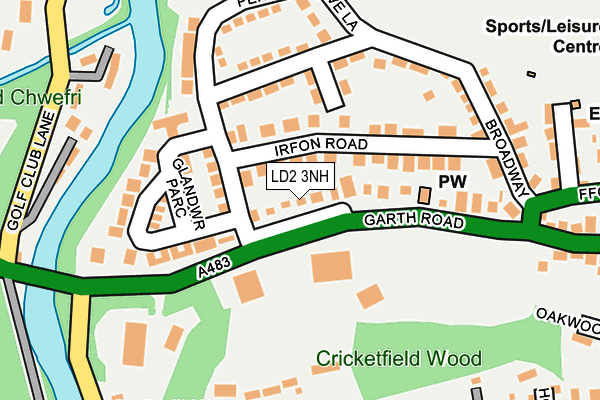
LD2 3NH lies on Garth Road in Builth Wells. LD2 3NH is located in the Builth electoral ward, within the unitary authority of Powys and the Welsh Parliamentary constituency of Brecon and Radnorshire. The Local Health Board is Powys Teaching and the police force is Dyfed-Powys. This postcode has been in use since January 1980.


GetTheData
Source: OS OpenMap – Local (Ordnance Survey)
Source: OS VectorMap District (Ordnance Survey)
Licence: Open Government Licence (requires attribution)
| Easting | 303403 |
| Northing | 251111 |
| Latitude | 52.149805 |
| Longitude | -3.413210 |
GetTheData
Source: Open Postcode Geo
Licence: Open Government Licence
| Street | Garth Road |
| Town/City | Builth Wells |
| Country | Wales |
| Postcode District | LD2 |
➜ See where LD2 is on a map ➜ Where is Builth Wells? | |
GetTheData
Source: Land Registry Price Paid Data
Licence: Open Government Licence
Elevation or altitude of LD2 3NH as distance above sea level:
| Metres | Feet | |
|---|---|---|
| Elevation | 130m | 427ft |
Elevation is measured from the approximate centre of the postcode, to the nearest point on an OS contour line from OS Terrain 50, which has contour spacing of ten vertical metres.
➜ How high above sea level am I? Find the elevation of your current position using your device's GPS.
GetTheData
Source: Open Postcode Elevation
Licence: Open Government Licence
| Ward | Builth |
| Constituency | Brecon And Radnorshire |
GetTheData
Source: ONS Postcode Database
Licence: Open Government Licence
2024 25 APR £280,000 |
2020 5 AUG £100,000 |
2019 28 JUN £197,500 |
69, GARTH ROAD, BUILTH WELLS, LD2 3NH 2008 30 SEP £176,000 |
2004 12 MAY £155,000 |
1998 22 SEP £55,100 |
1997 24 OCT £65,000 |
63, GARTH ROAD, BUILTH WELLS, LD2 3NH 1996 16 AUG £66,000 |
GetTheData
Source: HM Land Registry Price Paid Data
Licence: Contains HM Land Registry data © Crown copyright and database right 2025. This data is licensed under the Open Government Licence v3.0.
| Pendre Surgery (Pendre) | Builth Wells | 118m |
| Brynhyfryd (Pendre) | Builth Wells | 212m |
| Broadway | Builth Wells | 213m |
| Daffodil Wood (Hospital Road) | Builth Wells | 327m |
| Cottage Hospital (Oakwood Close) | Builth Wells | 354m |
| Builth Road Station | 2.4km |
| Cilmeri Station | 3km |
GetTheData
Source: NaPTAN
Licence: Open Government Licence
| Percentage of properties with Next Generation Access | 100.0% |
| Percentage of properties with Superfast Broadband | 100.0% |
| Percentage of properties with Ultrafast Broadband | 100.0% |
| Percentage of properties with Full Fibre Broadband | 100.0% |
Superfast Broadband is between 30Mbps and 300Mbps
Ultrafast Broadband is > 300Mbps
| Percentage of properties unable to receive 2Mbps | 0.0% |
| Percentage of properties unable to receive 5Mbps | 0.0% |
| Percentage of properties unable to receive 10Mbps | 0.0% |
| Percentage of properties unable to receive 30Mbps | 0.0% |
GetTheData
Source: Ofcom
Licence: Ofcom Terms of Use (requires attribution)
Estimated total energy consumption in LD2 3NH by fuel type, 2015.
| Consumption (kWh) | 141,431 |
|---|---|
| Meter count | 8 |
| Mean (kWh/meter) | 17,679 |
| Median (kWh/meter) | 16,181 |
| Consumption (kWh) | 17,995 |
|---|---|
| Meter count | 7 |
| Mean (kWh/meter) | 2,571 |
| Median (kWh/meter) | 2,760 |
GetTheData
Source: Postcode level gas estimates: 2015 (experimental)
Source: Postcode level electricity estimates: 2015 (experimental)
Licence: Open Government Licence
GetTheData
Source: ONS Postcode Database
Licence: Open Government Licence

➜ Get more ratings from the Food Standards Agency
GetTheData
Source: Food Standards Agency
Licence: FSA terms & conditions
| Last Collection | |||
|---|---|---|---|
| Location | Mon-Fri | Sat | Distance |
| Pendre | 17:00 | 10:00 | 145m |
| Broadway | 17:00 | 11:00 | 218m |
| Hospital Road | 17:00 | 09:00 | 313m |
GetTheData
Source: Dracos
Licence: Creative Commons Attribution-ShareAlike
The below table lists the International Territorial Level (ITL) codes (formerly Nomenclature of Territorial Units for Statistics (NUTS) codes) and Local Administrative Units (LAU) codes for LD2 3NH:
| ITL 1 Code | Name |
|---|---|
| TLL | Wales |
| ITL 2 Code | Name |
| TLL2 | East Wales |
| ITL 3 Code | Name |
| TLL24 | Powys |
| LAU 1 Code | Name |
| W06000023 | Powys |
GetTheData
Source: ONS Postcode Directory
Licence: Open Government Licence
The below table lists the Census Output Area (OA), Lower Layer Super Output Area (LSOA), and Middle Layer Super Output Area (MSOA) for LD2 3NH:
| Code | Name | |
|---|---|---|
| OA | W00002295 | |
| LSOA | W01000432 | Powys 014B |
| MSOA | W02000110 | Powys 014 |
GetTheData
Source: ONS Postcode Directory
Licence: Open Government Licence
| LD2 3DE | Irfon Road | 87m |
| LD2 3BY | The Bungalows | 115m |
| LD2 3DF | Glandwr Park | 141m |
| LD2 3DA | Pendre | 147m |
| LD2 3AS | Garth Road | 161m |
| LD2 3DB | Broadway | 192m |
| LD2 3NN | Golf Club Lane | 248m |
| LD2 3AU | Park Road | 277m |
| LD2 3LE | Daffodil Wood | 297m |
| LD2 3HE | Hospital Road | 306m |
GetTheData
Source: Open Postcode Geo; Land Registry Price Paid Data
Licence: Open Government Licence