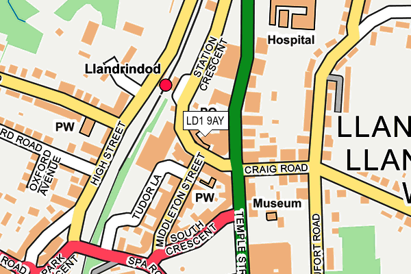
LD1 9AY is located in the Llandrindod South electoral ward, within the unitary authority of Powys and the Welsh Parliamentary constituency of Brecon and Radnorshire. The Local Health Board is Powys Teaching and the police force is Dyfed-Powys. This postcode has been in use since March 2022.


GetTheData
Source: OS OpenMap – Local (Ordnance Survey)
Source: OS VectorMap District (Ordnance Survey)
Licence: Open Government Licence (requires attribution)
| Easting | 305975 |
| Northing | 261281 |
| Latitude | 52.241666 |
| Longitude | -3.378464 |
GetTheData
Source: Open Postcode Geo
Licence: Open Government Licence
| Country | Wales |
| Postcode District | LD1 |
➜ See where LD1 is on a map ➜ Where is Llandrindod Wells? | |
GetTheData
Source: Land Registry Price Paid Data
Licence: Open Government Licence
Elevation or altitude of LD1 9AY as distance above sea level:
| Metres | Feet | |
|---|---|---|
| Elevation | 210m | 689ft |
Elevation is measured from the approximate centre of the postcode, to the nearest point on an OS contour line from OS Terrain 50, which has contour spacing of ten vertical metres.
➜ How high above sea level am I? Find the elevation of your current position using your device's GPS.
GetTheData
Source: Open Postcode Elevation
Licence: Open Government Licence
| Ward | Llandrindod South |
| Constituency | Brecon And Radnorshire |
GetTheData
Source: ONS Postcode Database
Licence: Open Government Licence
| Post Office (Station Crescent) | Llandrindod Wells | 34m |
| Tremont Road | Llandrindod Wells | 41m |
| Tremont Road | Llandrindod Wells | 49m |
| Station (Station Crescent) | Llandrindod Wells | 65m |
| Station (Station Crescent) | Llandrindod Wells | 77m |
| Llandrindod Station | 0.1km |
| Pen-y-Bont Station | 5.3km |
GetTheData
Source: NaPTAN
Licence: Open Government Licence
GetTheData
Source: ONS Postcode Database
Licence: Open Government Licence


➜ Get more ratings from the Food Standards Agency
GetTheData
Source: Food Standards Agency
Licence: FSA terms & conditions
| Last Collection | |||
|---|---|---|---|
| Location | Mon-Fri | Sat | Distance |
| Station Crescent Post Office | 19:00 | 13:00 | 21m |
| Lant Avenue | 18:15 | 12:00 | 304m |
| Gwalia Square | 17:30 | 12:00 | 349m |
GetTheData
Source: Dracos
Licence: Creative Commons Attribution-ShareAlike
The below table lists the International Territorial Level (ITL) codes (formerly Nomenclature of Territorial Units for Statistics (NUTS) codes) and Local Administrative Units (LAU) codes for LD1 9AY:
| ITL 1 Code | Name |
|---|---|
| TLL | Wales |
| ITL 2 Code | Name |
| TLL2 | East Wales |
| ITL 3 Code | Name |
| TLL24 | Powys |
| LAU 1 Code | Name |
| W06000023 | Powys |
GetTheData
Source: ONS Postcode Directory
Licence: Open Government Licence
The below table lists the Census Output Area (OA), Lower Layer Super Output Area (LSOA), and Middle Layer Super Output Area (MSOA) for LD1 9AY:
| Code | Name | |
|---|---|---|
| OA | W00002420 | |
| LSOA | W01000454 | Powys 013A |
| MSOA | W02000109 | Powys 013 |
GetTheData
Source: ONS Postcode Directory
Licence: Open Government Licence
| LD1 5BB | Station Crescent | 12m |
| LD1 5BD | Station Crescent | 54m |
| LD1 5HF | Temple Street | 85m |
| LD1 5DG | Middleton Street | 99m |
| LD1 5DL | Temple Street | 105m |
| LD1 5HS | Craig Road | 120m |
| LD1 5ET | Middleton Street | 123m |
| LD1 5DH | Middleton Street | 126m |
| LD1 5EE | Beaufort Road | 167m |
| LD1 6BG | High Street | 173m |
GetTheData
Source: Open Postcode Geo; Land Registry Price Paid Data
Licence: Open Government Licence