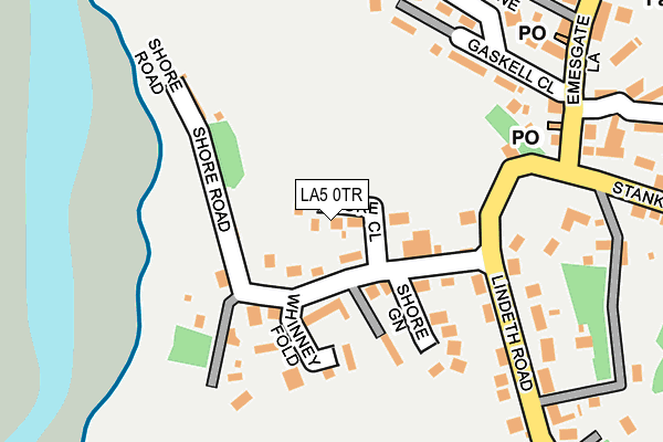
LA5 0TR lies on Shore Close in Silverdale, Carnforth. LA5 0TR is located in the Silverdale electoral ward, within the local authority district of Lancaster and the English Parliamentary constituency of Morecambe and Lunesdale. The Sub Integrated Care Board (ICB) Location is NHS Lancashire and South Cumbria ICB - 01K and the police force is Lancashire. This postcode has been in use since January 1980.


GetTheData
Source: OS OpenMap – Local (Ordnance Survey)
Source: OS VectorMap District (Ordnance Survey)
Licence: Open Government Licence (requires attribution)
| Easting | 345903 |
| Northing | 474902 |
| Latitude | 54.167051 |
| Longitude | -2.830086 |
GetTheData
Source: Open Postcode Geo
Licence: Open Government Licence
| Street | Shore Close |
| Locality | Silverdale |
| Town/City | Carnforth |
| Country | England |
| Postcode District | LA5 |
➜ See where LA5 is on a map ➜ Where is Silverdale? | |
GetTheData
Source: Land Registry Price Paid Data
Licence: Open Government Licence
Elevation or altitude of LA5 0TR as distance above sea level:
| Metres | Feet | |
|---|---|---|
| Elevation | 10m | 33ft |
Elevation is measured from the approximate centre of the postcode, to the nearest point on an OS contour line from OS Terrain 50, which has contour spacing of ten vertical metres.
➜ How high above sea level am I? Find the elevation of your current position using your device's GPS.
GetTheData
Source: Open Postcode Elevation
Licence: Open Government Licence
| Ward | Silverdale |
| Constituency | Morecambe And Lunesdale |
GetTheData
Source: ONS Postcode Database
Licence: Open Government Licence
1, SHORE CLOSE, SILVERDALE, CARNFORTH, LA5 0TR 2009 17 SEP £312,500 |
SILVERDALE COTTAGE, SHORE CLOSE, SILVERDALE, CARNFORTH, LA5 0TR 2002 6 MAR £189,000 |
5, SHORE CLOSE, SILVERDALE, CARNFORTH, LA5 0TR 2001 6 NOV £162,500 |
GetTheData
Source: HM Land Registry Price Paid Data
Licence: Contains HM Land Registry data © Crown copyright and database right 2025. This data is licensed under the Open Government Licence v3.0.
| Stankelt Road | Silverdale | 134m |
| The Royal (Emesgate Lane) | Silverdale | 251m |
| The Royal (Emesgate Lane) | Silverdale | 266m |
| Gaskell Hall (Emesgate Lane) | Silverdale | 309m |
| Lindeth Close | Silverdale | 375m |
| Silverdale Station | 1.7km |
| Arnside Station | 4km |
| Carnforth Station | 5.7km |
GetTheData
Source: NaPTAN
Licence: Open Government Licence
| Percentage of properties with Next Generation Access | 100.0% |
| Percentage of properties with Superfast Broadband | 100.0% |
| Percentage of properties with Ultrafast Broadband | 100.0% |
| Percentage of properties with Full Fibre Broadband | 100.0% |
Superfast Broadband is between 30Mbps and 300Mbps
Ultrafast Broadband is > 300Mbps
| Percentage of properties unable to receive 2Mbps | 0.0% |
| Percentage of properties unable to receive 5Mbps | 0.0% |
| Percentage of properties unable to receive 10Mbps | 0.0% |
| Percentage of properties unable to receive 30Mbps | 0.0% |
GetTheData
Source: Ofcom
Licence: Ofcom Terms of Use (requires attribution)
GetTheData
Source: ONS Postcode Database
Licence: Open Government Licence


➜ Get more ratings from the Food Standards Agency
GetTheData
Source: Food Standards Agency
Licence: FSA terms & conditions
| Last Collection | |||
|---|---|---|---|
| Location | Mon-Fri | Sat | Distance |
| Redhills Road, Arnside | 16:15 | 10:00 | 3,497m |
| Arnside Post Office | 16:30 | 11:00 | 3,941m |
| Millhead | 17:00 | 11:30 | 5,148m |
GetTheData
Source: Dracos
Licence: Creative Commons Attribution-ShareAlike
The below table lists the International Territorial Level (ITL) codes (formerly Nomenclature of Territorial Units for Statistics (NUTS) codes) and Local Administrative Units (LAU) codes for LA5 0TR:
| ITL 1 Code | Name |
|---|---|
| TLD | North West (England) |
| ITL 2 Code | Name |
| TLD4 | Lancashire |
| ITL 3 Code | Name |
| TLD44 | Lancaster and Wyre |
| LAU 1 Code | Name |
| E07000121 | Lancaster |
GetTheData
Source: ONS Postcode Directory
Licence: Open Government Licence
The below table lists the Census Output Area (OA), Lower Layer Super Output Area (LSOA), and Middle Layer Super Output Area (MSOA) for LA5 0TR:
| Code | Name | |
|---|---|---|
| OA | E00127634 | |
| LSOA | E01025148 | Lancaster 001E |
| MSOA | E02005221 | Lancaster 001 |
GetTheData
Source: ONS Postcode Directory
Licence: Open Government Licence
| LA5 0TP | Shore Road | 73m |
| LA5 0TW | Stankelt Road | 125m |
| LA5 0JG | Whinney Fold | 137m |
| LA5 0UL | Shore Green | 153m |
| LA5 0TS | Shore Cottages | 169m |
| LA5 0RD | Gaskell Close | 217m |
| LA5 0US | Yew Tree Gardens | 252m |
| LA5 0RA | Emesgate Lane | 257m |
| LA5 0TT | Lindeth Road | 260m |
| LA5 0TB | Beech Court | 284m |
GetTheData
Source: Open Postcode Geo; Land Registry Price Paid Data
Licence: Open Government Licence