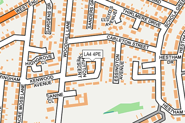
LA4 4PE lies on Hutton Crescent in Morecambe. LA4 4PE is located in the West End electoral ward, within the local authority district of Lancaster and the English Parliamentary constituency of Morecambe and Lunesdale. The Sub Integrated Care Board (ICB) Location is NHS Lancashire and South Cumbria ICB - 01K and the police force is Lancashire. This postcode has been in use since January 1980.


GetTheData
Source: OS OpenMap – Local (Ordnance Survey)
Source: OS VectorMap District (Ordnance Survey)
Licence: Open Government Licence (requires attribution)
| Easting | 343416 |
| Northing | 463804 |
| Latitude | 54.067051 |
| Longitude | -2.866092 |
GetTheData
Source: Open Postcode Geo
Licence: Open Government Licence
| Street | Hutton Crescent |
| Town/City | Morecambe |
| Country | England |
| Postcode District | LA4 |
➜ See where LA4 is on a map ➜ Where is Morecambe? | |
GetTheData
Source: Land Registry Price Paid Data
Licence: Open Government Licence
Elevation or altitude of LA4 4PE as distance above sea level:
| Metres | Feet | |
|---|---|---|
| Elevation | 10m | 33ft |
Elevation is measured from the approximate centre of the postcode, to the nearest point on an OS contour line from OS Terrain 50, which has contour spacing of ten vertical metres.
➜ How high above sea level am I? Find the elevation of your current position using your device's GPS.
GetTheData
Source: Open Postcode Elevation
Licence: Open Government Licence
| Ward | West End |
| Constituency | Morecambe And Lunesdale |
GetTheData
Source: ONS Postcode Database
Licence: Open Government Licence
| Carleton Street (Woodhill Lane) | Morecambe | 92m |
| Carleton Street (Woodhill Lane) | Morecambe | 98m |
| Kenwood Avenue | West End | 175m |
| Kenwood Avenue | West End | 201m |
| Schola Green Lane (Carleton Street) | Morecambe | 207m |
| Morecambe Station | 0.4km |
| Bare Lane Station | 2.2km |
| Lancaster Station | 4.3km |
GetTheData
Source: NaPTAN
Licence: Open Government Licence
| Percentage of properties with Next Generation Access | 100.0% |
| Percentage of properties with Superfast Broadband | 100.0% |
| Percentage of properties with Ultrafast Broadband | 0.0% |
| Percentage of properties with Full Fibre Broadband | 0.0% |
Superfast Broadband is between 30Mbps and 300Mbps
Ultrafast Broadband is > 300Mbps
| Median download speed | 39.1Mbps |
| Average download speed | 35.7Mbps |
| Maximum download speed | 73.43Mbps |
| Median upload speed | 9.3Mbps |
| Average upload speed | 8.2Mbps |
| Maximum upload speed | 20.00Mbps |
| Percentage of properties unable to receive 2Mbps | 0.0% |
| Percentage of properties unable to receive 5Mbps | 0.0% |
| Percentage of properties unable to receive 10Mbps | 0.0% |
| Percentage of properties unable to receive 30Mbps | 0.0% |
GetTheData
Source: Ofcom
Licence: Ofcom Terms of Use (requires attribution)
Estimated total energy consumption in LA4 4PE by fuel type, 2015.
| Consumption (kWh) | 252,516 |
|---|---|
| Meter count | 26 |
| Mean (kWh/meter) | 9,712 |
| Median (kWh/meter) | 9,137 |
| Consumption (kWh) | 62,929 |
|---|---|
| Meter count | 20 |
| Mean (kWh/meter) | 3,146 |
| Median (kWh/meter) | 2,896 |
GetTheData
Source: Postcode level gas estimates: 2015 (experimental)
Source: Postcode level electricity estimates: 2015 (experimental)
Licence: Open Government Licence
GetTheData
Source: ONS Postcode Database
Licence: Open Government Licence


➜ Get more ratings from the Food Standards Agency
GetTheData
Source: Food Standards Agency
Licence: FSA terms & conditions
| Last Collection | |||
|---|---|---|---|
| Location | Mon-Fri | Sat | Distance |
| Carlton Street | 16:30 | 12:00 | 207m |
| Woodhill Lane | 16:30 | 12:00 | 231m |
| Albany Road | 16:00 | 12:00 | 347m |
GetTheData
Source: Dracos
Licence: Creative Commons Attribution-ShareAlike
The below table lists the International Territorial Level (ITL) codes (formerly Nomenclature of Territorial Units for Statistics (NUTS) codes) and Local Administrative Units (LAU) codes for LA4 4PE:
| ITL 1 Code | Name |
|---|---|
| TLD | North West (England) |
| ITL 2 Code | Name |
| TLD4 | Lancashire |
| ITL 3 Code | Name |
| TLD44 | Lancaster and Wyre |
| LAU 1 Code | Name |
| E07000121 | Lancaster |
GetTheData
Source: ONS Postcode Directory
Licence: Open Government Licence
The below table lists the Census Output Area (OA), Lower Layer Super Output Area (LSOA), and Middle Layer Super Output Area (MSOA) for LA4 4PE:
| Code | Name | |
|---|---|---|
| OA | E00127434 | |
| LSOA | E01025111 | Lancaster 008A |
| MSOA | E02005228 | Lancaster 008 |
GetTheData
Source: ONS Postcode Directory
Licence: Open Government Licence
| LA4 4PD | Hutton Grove | 39m |
| LA4 4NN | Woodhill Lane | 71m |
| LA4 4NX | Carleton Street | 78m |
| LA4 4PA | Essington Avenue | 94m |
| LA4 4NY | Carleton Street | 114m |
| LA4 4NT | Dennis Grove | 134m |
| LA4 4NF | Highgrove Close | 145m |
| LA4 4NZ | Sanders Grove | 151m |
| LA4 4NU | Lloyds Avenue | 155m |
| LA4 4QJ | Hidings Court Lane | 157m |
GetTheData
Source: Open Postcode Geo; Land Registry Price Paid Data
Licence: Open Government Licence