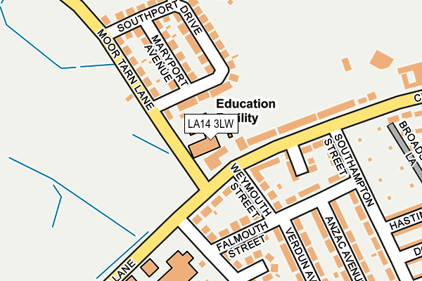
LA14 3LW lies on Moor Tarn Lane in Walney, Barrow-in-furness. LA14 3LW is located in the Walney Island electoral ward, within the unitary authority of Westmorland and Furness and the English Parliamentary constituency of Barrow and Furness. The Sub Integrated Care Board (ICB) Location is NHS Lancashire and South Cumbria ICB - 01K and the police force is Cumbria. This postcode has been in use since January 1980.


GetTheData
Source: OS OpenMap – Local (Ordnance Survey)
Source: OS VectorMap District (Ordnance Survey)
Licence: Open Government Licence (requires attribution)
| Easting | 317872 |
| Northing | 468602 |
| Latitude | 54.106727 |
| Longitude | -3.257615 |
GetTheData
Source: Open Postcode Geo
Licence: Open Government Licence
| Street | Moor Tarn Lane |
| Locality | Walney |
| Town/City | Barrow-in-furness |
| Country | England |
| Postcode District | LA14 |
➜ See where LA14 is on a map ➜ Where is Barrow-in-Furness? | |
GetTheData
Source: Land Registry Price Paid Data
Licence: Open Government Licence
Elevation or altitude of LA14 3LW as distance above sea level:
| Metres | Feet | |
|---|---|---|
| Elevation | 20m | 66ft |
Elevation is measured from the approximate centre of the postcode, to the nearest point on an OS contour line from OS Terrain 50, which has contour spacing of ten vertical metres.
➜ How high above sea level am I? Find the elevation of your current position using your device's GPS.
GetTheData
Source: Open Postcode Elevation
Licence: Open Government Licence
| Ward | Walney Island |
| Constituency | Barrow And Furness |
GetTheData
Source: ONS Postcode Database
Licence: Open Government Licence
| Furness Golf Club (Moor Tarn Lane) | West Shore | 48m |
| Furness Golf Club (Central Drive) | Walney | 59m |
| Southport Drive (Moor Tarn Lane) | West Shore | 142m |
| George Hotel (Central Drive) | Walney | 164m |
| The George Hotel (Southampton Street) | South Walney | 175m |
| Barrow-in-Furness Station | 2.5km |
| Roose Station | 4.2km |
GetTheData
Source: NaPTAN
Licence: Open Government Licence
| Percentage of properties with Next Generation Access | 100.0% |
| Percentage of properties with Superfast Broadband | 100.0% |
| Percentage of properties with Ultrafast Broadband | 0.0% |
| Percentage of properties with Full Fibre Broadband | 0.0% |
Superfast Broadband is between 30Mbps and 300Mbps
Ultrafast Broadband is > 300Mbps
| Percentage of properties unable to receive 2Mbps | 0.0% |
| Percentage of properties unable to receive 5Mbps | 0.0% |
| Percentage of properties unable to receive 10Mbps | 0.0% |
| Percentage of properties unable to receive 30Mbps | 0.0% |
GetTheData
Source: Ofcom
Licence: Ofcom Terms of Use (requires attribution)
GetTheData
Source: ONS Postcode Database
Licence: Open Government Licence


➜ Get more ratings from the Food Standards Agency
GetTheData
Source: Food Standards Agency
Licence: FSA terms & conditions
| Last Collection | |||
|---|---|---|---|
| Location | Mon-Fri | Sat | Distance |
| Douglas Street Post Office | 16:45 | 11:00 | 784m |
| North Scale, Walney Island | 16:00 | 11:00 | 1,350m |
| Duke Street Post Office | 17:30 | 12:15 | 1,938m |
GetTheData
Source: Dracos
Licence: Creative Commons Attribution-ShareAlike
The below table lists the International Territorial Level (ITL) codes (formerly Nomenclature of Territorial Units for Statistics (NUTS) codes) and Local Administrative Units (LAU) codes for LA14 3LW:
| ITL 1 Code | Name |
|---|---|
| TLD | North West (England) |
| ITL 2 Code | Name |
| TLD1 | Cumbria |
| ITL 3 Code | Name |
| TLD11 | West Cumbria |
| LAU 1 Code | Name |
| E07000027 | Barrow-in-Furness |
GetTheData
Source: ONS Postcode Directory
Licence: Open Government Licence
The below table lists the Census Output Area (OA), Lower Layer Super Output Area (LSOA), and Middle Layer Super Output Area (MSOA) for LA14 3LW:
| Code | Name | |
|---|---|---|
| OA | E00096943 | |
| LSOA | E01019182 | Barrow-in-Furness 009C |
| MSOA | E02003985 | Barrow-in-Furness 009 |
GetTheData
Source: ONS Postcode Directory
Licence: Open Government Licence
| LA14 3HZ | Central Drive | 77m |
| LA14 3JF | Weymouth Street | 114m |
| LA14 3HT | Fairways Drive | 122m |
| LA14 3JG | Falmouth Street | 127m |
| LA14 3LT | Southport Drive | 128m |
| LA14 3JH | Black Butts Lane | 135m |
| LA14 3LR | Maryport Avenue | 144m |
| LA14 3LP | Moor Tarn Lane | 161m |
| LA14 3JQ | Falmouth Street | 162m |
| LA14 3JX | Snaefell View | 182m |
GetTheData
Source: Open Postcode Geo; Land Registry Price Paid Data
Licence: Open Government Licence