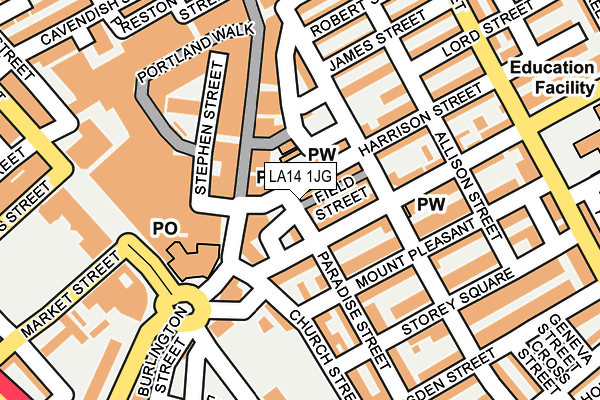
LA14 1JG is located in the Old Barrow and Hindpool electoral ward, within the unitary authority of Westmorland and Furness and the English Parliamentary constituency of Barrow and Furness. The Sub Integrated Care Board (ICB) Location is NHS Lancashire and South Cumbria ICB - 01K and the police force is Cumbria. This postcode has been in use since January 1980.


GetTheData
Source: OS OpenMap – Local (Ordnance Survey)
Source: OS VectorMap District (Ordnance Survey)
Licence: Open Government Licence (requires attribution)
| Easting | 320045 |
| Northing | 469127 |
| Latitude | 54.111779 |
| Longitude | -3.224530 |
GetTheData
Source: Open Postcode Geo
Licence: Open Government Licence
| Country | England |
| Postcode District | LA14 |
➜ See where LA14 is on a map ➜ Where is Barrow-in-Furness? | |
GetTheData
Source: Land Registry Price Paid Data
Licence: Open Government Licence
Elevation or altitude of LA14 1JG as distance above sea level:
| Metres | Feet | |
|---|---|---|
| Elevation | 10m | 33ft |
Elevation is measured from the approximate centre of the postcode, to the nearest point on an OS contour line from OS Terrain 50, which has contour spacing of ten vertical metres.
➜ How high above sea level am I? Find the elevation of your current position using your device's GPS.
GetTheData
Source: Open Postcode Elevation
Licence: Open Government Licence
| Ward | Old Barrow And Hindpool |
| Constituency | Barrow And Furness |
GetTheData
Source: ONS Postcode Database
Licence: Open Government Licence
| Market Hall (Duke Street) | Barrow-in-furness | 152m |
| St George's School (Duke Street) | Barrow-in-furness | 195m |
| St Georges School (Duke Street) | Barrow-in-furness | 210m |
| County Court (Market Street) | Barrow-in-furness | 216m |
| Town Hall (Cornwallis St) | Barrow-in-furness | 232m |
| Barrow-in-Furness Station | 0.8km |
| Roose Station | 2km |
| Dalton Station | 5.6km |
GetTheData
Source: NaPTAN
Licence: Open Government Licence
GetTheData
Source: ONS Postcode Database
Licence: Open Government Licence


➜ Get more ratings from the Food Standards Agency
GetTheData
Source: Food Standards Agency
Licence: FSA terms & conditions
| Last Collection | |||
|---|---|---|---|
| Location | Mon-Fri | Sat | Distance |
| Town Hall | 18:00 | 11:00 | 81m |
| Furness House Post Office | 18:00 | 12:30 | 136m |
| Duke Street Post Office | 17:30 | 12:15 | 459m |
GetTheData
Source: Dracos
Licence: Creative Commons Attribution-ShareAlike
The below table lists the International Territorial Level (ITL) codes (formerly Nomenclature of Territorial Units for Statistics (NUTS) codes) and Local Administrative Units (LAU) codes for LA14 1JG:
| ITL 1 Code | Name |
|---|---|
| TLD | North West (England) |
| ITL 2 Code | Name |
| TLD1 | Cumbria |
| ITL 3 Code | Name |
| TLD11 | West Cumbria |
| LAU 1 Code | Name |
| E07000027 | Barrow-in-Furness |
GetTheData
Source: ONS Postcode Directory
Licence: Open Government Licence
The below table lists the Census Output Area (OA), Lower Layer Super Output Area (LSOA), and Middle Layer Super Output Area (MSOA) for LA14 1JG:
| Code | Name | |
|---|---|---|
| OA | E00096743 | |
| LSOA | E01019141 | Barrow-in-Furness 008A |
| MSOA | E02003984 | Barrow-in-Furness 008 |
GetTheData
Source: ONS Postcode Directory
Licence: Open Government Licence
| LA14 1JF | Harrison Street | 43m |
| LA14 1HE | Greengate Street | 46m |
| LA14 1JB | Dalton Road | 57m |
| LA14 1HB | Greengate Street | 62m |
| LA14 1HD | Paradise Street | 68m |
| LA14 1HA | Church Street | 71m |
| LA14 2HR | Mount Pleasant | 86m |
| LA14 1JS | Paxton Street | 87m |
| LA14 1DX | The Ginnel | 87m |
| LA14 2HP | Mount Pleasant | 88m |
GetTheData
Source: Open Postcode Geo; Land Registry Price Paid Data
Licence: Open Government Licence