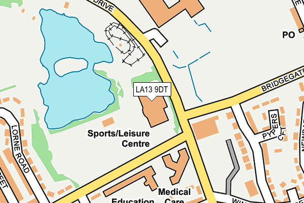
LA13 9DT is located in the Ormsgill and Parkside electoral ward, within the unitary authority of Westmorland and Furness and the English Parliamentary constituency of Barrow and Furness. The Sub Integrated Care Board (ICB) Location is NHS Lancashire and South Cumbria ICB - 01K and the police force is Cumbria. This postcode has been in use since January 1992.


GetTheData
Source: OS OpenMap – Local (Ordnance Survey)
Source: OS VectorMap District (Ordnance Survey)
Licence: Open Government Licence (requires attribution)
| Easting | 320860 |
| Northing | 469622 |
| Latitude | 54.116353 |
| Longitude | -3.212197 |
GetTheData
Source: Open Postcode Geo
Licence: Open Government Licence
| Country | England |
| Postcode District | LA13 |
➜ See where LA13 is on a map ➜ Where is Barrow-in-Furness? | |
GetTheData
Source: Land Registry Price Paid Data
Licence: Open Government Licence
Elevation or altitude of LA13 9DT as distance above sea level:
| Metres | Feet | |
|---|---|---|
| Elevation | 10m | 33ft |
Elevation is measured from the approximate centre of the postcode, to the nearest point on an OS contour line from OS Terrain 50, which has contour spacing of ten vertical metres.
➜ How high above sea level am I? Find the elevation of your current position using your device's GPS.
GetTheData
Source: Open Postcode Elevation
Licence: Open Government Licence
| Ward | Ormsgill And Parkside |
| Constituency | Barrow And Furness |
GetTheData
Source: ONS Postcode Database
Licence: Open Government Licence
| Park Leisure Centre (Greengate Street) | Salthouse | 85m |
| Park Leisure Centre (Greengate Street) | Salthouse | 99m |
| George Basterfield House (Risedale Road) | Salthouse | 184m |
| Furness Academy South (Park Drive) | Barrow-in-furness | 286m |
| Furness Academy South (Park Drive) | Barrow-in-furness | 292m |
| Barrow-in-Furness Station | 1km |
| Roose Station | 1.2km |
| Dalton Station | 4.7km |
GetTheData
Source: NaPTAN
Licence: Open Government Licence
GetTheData
Source: ONS Postcode Database
Licence: Open Government Licence


➜ Get more ratings from the Food Standards Agency
GetTheData
Source: Food Standards Agency
Licence: FSA terms & conditions
| Last Collection | |||
|---|---|---|---|
| Location | Mon-Fri | Sat | Distance |
| Greengate Street | 17:30 | 11:00 | 426m |
| Barrow Delivery Office | 17:30 | 12:30 | 836m |
| Victoria Avenue | 17:30 | 11:00 | 855m |
GetTheData
Source: Dracos
Licence: Creative Commons Attribution-ShareAlike
The below table lists the International Territorial Level (ITL) codes (formerly Nomenclature of Territorial Units for Statistics (NUTS) codes) and Local Administrative Units (LAU) codes for LA13 9DT:
| ITL 1 Code | Name |
|---|---|
| TLD | North West (England) |
| ITL 2 Code | Name |
| TLD1 | Cumbria |
| ITL 3 Code | Name |
| TLD11 | West Cumbria |
| LAU 1 Code | Name |
| E07000027 | Barrow-in-Furness |
GetTheData
Source: ONS Postcode Directory
Licence: Open Government Licence
The below table lists the Census Output Area (OA), Lower Layer Super Output Area (LSOA), and Middle Layer Super Output Area (MSOA) for LA13 9DT:
| Code | Name | |
|---|---|---|
| OA | E00096893 | |
| LSOA | E01019168 | Barrow-in-Furness 005B |
| MSOA | E02003981 | Barrow-in-Furness 005 |
GetTheData
Source: ONS Postcode Directory
Licence: Open Government Licence
| LA13 9DB | Worcester Street | 212m |
| LA13 9BS | Greengate Street | 241m |
| LA13 9DE | Bridgegate Avenue | 246m |
| LA13 9QL | Cecil Street | 249m |
| LA13 9DD | Pypers Croft | 262m |
| LA13 9QB | Jarrow Street | 279m |
| LA13 9SQ | Worcester Street | 281m |
| LA13 9BX | Greengate Street | 284m |
| LA13 9BP | Lorne Road | 298m |
| LA13 9QN | Leicester Street | 298m |
GetTheData
Source: Open Postcode Geo; Land Registry Price Paid Data
Licence: Open Government Licence