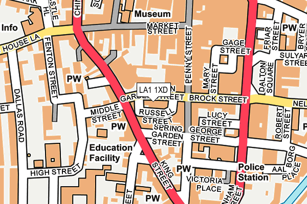
LA1 1XD lies on Common Garden Street in Lancaster. LA1 1XD is located in the Castle electoral ward, within the local authority district of Lancaster and the English Parliamentary constituency of Lancaster and Fleetwood. The Sub Integrated Care Board (ICB) Location is NHS Lancashire and South Cumbria ICB - 01K and the police force is Lancashire. This postcode has been in use since January 1980.


GetTheData
Source: OS OpenMap – Local (Ordnance Survey)
Source: OS VectorMap District (Ordnance Survey)
Licence: Open Government Licence (requires attribution)
| Easting | 347667 |
| Northing | 461563 |
| Latitude | 54.047372 |
| Longitude | -2.800753 |
GetTheData
Source: Open Postcode Geo
Licence: Open Government Licence
| Street | Common Garden Street |
| Town/City | Lancaster |
| Country | England |
| Postcode District | LA1 |
➜ See where LA1 is on a map ➜ Where is Lancaster? | |
GetTheData
Source: Land Registry Price Paid Data
Licence: Open Government Licence
Elevation or altitude of LA1 1XD as distance above sea level:
| Metres | Feet | |
|---|---|---|
| Elevation | 20m | 66ft |
Elevation is measured from the approximate centre of the postcode, to the nearest point on an OS contour line from OS Terrain 50, which has contour spacing of ten vertical metres.
➜ How high above sea level am I? Find the elevation of your current position using your device's GPS.
GetTheData
Source: Open Postcode Elevation
Licence: Open Government Licence
| Ward | Castle |
| Constituency | Lancaster And Fleetwood |
GetTheData
Source: ONS Postcode Database
Licence: Open Government Licence
| Common Garden Street | Lancaster City Centre | 22m |
| Common Garden Street | Lancaster City Centre | 27m |
| Common Garden Street | Lancaster City Centre | 36m |
| Queens Square (King Street) | Lancaster City Centre | 93m |
| George Street | Lancaster City Centre | 116m |
| Lancaster Station | 0.5km |
| Bare Lane Station | 3.8km |
| Morecambe Station | 5.2km |
GetTheData
Source: NaPTAN
Licence: Open Government Licence
| Median download speed | 21.0Mbps |
| Average download speed | 22.0Mbps |
| Maximum download speed | 25.22Mbps |
| Median upload speed | 1.1Mbps |
| Average upload speed | 1.4Mbps |
| Maximum upload speed | 2.99Mbps |
GetTheData
Source: Ofcom
Licence: Ofcom Terms of Use (requires attribution)
GetTheData
Source: ONS Postcode Database
Licence: Open Government Licence


➜ Get more ratings from the Food Standards Agency
GetTheData
Source: Food Standards Agency
Licence: FSA terms & conditions
| Last Collection | |||
|---|---|---|---|
| Location | Mon-Fri | Sat | Distance |
| Queen Square | 17:30 | 12:00 | 103m |
| St Marys Church | 17:30 | 12:00 | 141m |
| New Street | 17:30 | 12:00 | 194m |
GetTheData
Source: Dracos
Licence: Creative Commons Attribution-ShareAlike
The below table lists the International Territorial Level (ITL) codes (formerly Nomenclature of Territorial Units for Statistics (NUTS) codes) and Local Administrative Units (LAU) codes for LA1 1XD:
| ITL 1 Code | Name |
|---|---|
| TLD | North West (England) |
| ITL 2 Code | Name |
| TLD4 | Lancashire |
| ITL 3 Code | Name |
| TLD44 | Lancaster and Wyre |
| LAU 1 Code | Name |
| E07000121 | Lancaster |
GetTheData
Source: ONS Postcode Directory
Licence: Open Government Licence
The below table lists the Census Output Area (OA), Lower Layer Super Output Area (LSOA), and Middle Layer Super Output Area (MSOA) for LA1 1XD:
| Code | Name | |
|---|---|---|
| OA | E00127404 | |
| LSOA | E01033071 | Lancaster 014E |
| MSOA | E02005234 | Lancaster 014 |
GetTheData
Source: ONS Postcode Directory
Licence: Open Government Licence
| LA1 1RQ | Spring Garden Street | 52m |
| LA1 1XF | Penny Street | 63m |
| LA1 1RE | King Street | 68m |
| LA1 1UP | James Street | 88m |
| LA1 1YF | Lucy Street | 95m |
| LA1 1JT | Slip Inn Lane | 98m |
| LA1 1JY | King Street | 100m |
| LA1 1RH | King Street | 108m |
| LA1 1JZ | Middle Street | 119m |
| LA1 1UA | Penny Street | 123m |
GetTheData
Source: Open Postcode Geo; Land Registry Price Paid Data
Licence: Open Government Licence