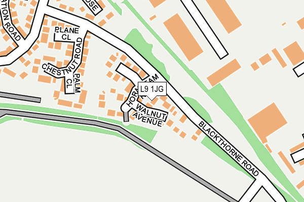
L9 1JG lies on Walnut Avenue in Liverpool. L9 1JG is located in the Walton electoral ward, within the metropolitan district of Liverpool and the English Parliamentary constituency of Liverpool, Walton. The Sub Integrated Care Board (ICB) Location is NHS Cheshire and Merseyside ICB - 99A and the police force is Merseyside. This postcode has been in use since March 1983.


GetTheData
Source: OS OpenMap – Local (Ordnance Survey)
Source: OS VectorMap District (Ordnance Survey)
Licence: Open Government Licence (requires attribution)
| Easting | 337203 |
| Northing | 395304 |
| Latitude | 53.450736 |
| Longitude | -2.947056 |
GetTheData
Source: Open Postcode Geo
Licence: Open Government Licence
| Street | Walnut Avenue |
| Town/City | Liverpool |
| Country | England |
| Postcode District | L9 |
➜ See where L9 is on a map ➜ Where is Liverpool? | |
GetTheData
Source: Land Registry Price Paid Data
Licence: Open Government Licence
Elevation or altitude of L9 1JG as distance above sea level:
| Metres | Feet | |
|---|---|---|
| Elevation | 30m | 98ft |
Elevation is measured from the approximate centre of the postcode, to the nearest point on an OS contour line from OS Terrain 50, which has contour spacing of ten vertical metres.
➜ How high above sea level am I? Find the elevation of your current position using your device's GPS.
GetTheData
Source: Open Postcode Elevation
Licence: Open Government Licence
| Ward | Walton |
| Constituency | Liverpool, Walton |
GetTheData
Source: ONS Postcode Database
Licence: Open Government Licence
16, WALNUT AVENUE, LIVERPOOL, L9 1JG 2024 10 SEP £220,000 |
GetTheData
Source: HM Land Registry Price Paid Data
Licence: Contains HM Land Registry data © Crown copyright and database right 2025. This data is licensed under the Open Government Licence v3.0.
| Chestnut Close (Blackthorne Road) | Walton | 119m |
| Forsythia Close (Blackthorne Road) | Walton | 136m |
| Forsythia Close (Blackthorne Road) | Walton | 148m |
| Chestnut Close (Blackthorne Road) | Walton | 163m |
| Walton Hall Park (Walton Hall Avenue) | Walton | 370m |
| Rice Lane Station | 1.3km |
| Walton (Merseyside) Station | 1.4km |
| Orrell Park Station | 1.6km |
GetTheData
Source: NaPTAN
Licence: Open Government Licence
| Percentage of properties with Next Generation Access | 100.0% |
| Percentage of properties with Superfast Broadband | 100.0% |
| Percentage of properties with Ultrafast Broadband | 100.0% |
| Percentage of properties with Full Fibre Broadband | 0.0% |
Superfast Broadband is between 30Mbps and 300Mbps
Ultrafast Broadband is > 300Mbps
| Median download speed | 60.0Mbps |
| Average download speed | 66.7Mbps |
| Maximum download speed | 200.00Mbps |
| Median upload speed | 0.6Mbps |
| Average upload speed | 0.6Mbps |
| Maximum upload speed | 0.78Mbps |
| Percentage of properties unable to receive 2Mbps | 0.0% |
| Percentage of properties unable to receive 5Mbps | 0.0% |
| Percentage of properties unable to receive 10Mbps | 0.0% |
| Percentage of properties unable to receive 30Mbps | 0.0% |
GetTheData
Source: Ofcom
Licence: Ofcom Terms of Use (requires attribution)
Estimated total energy consumption in L9 1JG by fuel type, 2015.
| Consumption (kWh) | 201,338 |
|---|---|
| Meter count | 19 |
| Mean (kWh/meter) | 10,597 |
| Median (kWh/meter) | 11,164 |
| Consumption (kWh) | 50,514 |
|---|---|
| Meter count | 17 |
| Mean (kWh/meter) | 2,971 |
| Median (kWh/meter) | 2,835 |
GetTheData
Source: Postcode level gas estimates: 2015 (experimental)
Source: Postcode level electricity estimates: 2015 (experimental)
Licence: Open Government Licence
GetTheData
Source: ONS Postcode Database
Licence: Open Government Licence


➜ Get more ratings from the Food Standards Agency
GetTheData
Source: Food Standards Agency
Licence: FSA terms & conditions
| Last Collection | |||
|---|---|---|---|
| Location | Mon-Fri | Sat | Distance |
| Cavendish Drive | 16:00 | 12:00 | 1,007m |
| Rice Lane | 16:00 | 12:00 | 1,058m |
| Walton Vale Post Office | 16:45 | 12:00 | 1,670m |
GetTheData
Source: Dracos
Licence: Creative Commons Attribution-ShareAlike
The below table lists the International Territorial Level (ITL) codes (formerly Nomenclature of Territorial Units for Statistics (NUTS) codes) and Local Administrative Units (LAU) codes for L9 1JG:
| ITL 1 Code | Name |
|---|---|
| TLD | North West (England) |
| ITL 2 Code | Name |
| TLD7 | Merseyside |
| ITL 3 Code | Name |
| TLD72 | Liverpool |
| LAU 1 Code | Name |
| E08000012 | Liverpool |
GetTheData
Source: ONS Postcode Directory
Licence: Open Government Licence
The below table lists the Census Output Area (OA), Lower Layer Super Output Area (LSOA), and Middle Layer Super Output Area (MSOA) for L9 1JG:
| Code | Name | |
|---|---|---|
| OA | E00165729 | |
| LSOA | E01032511 | Liverpool 008G |
| MSOA | E02001354 | Liverpool 008 |
GetTheData
Source: ONS Postcode Directory
Licence: Open Government Licence
| L9 1JA | Hornbeam Road | 53m |
| L9 1JF | Sycamore Close | 91m |
| L9 1HZ | Forsythia Close | 93m |
| L9 1JD | Palm Close | 182m |
| L9 1HY | Chestnut Road | 190m |
| L9 1JE | Plane Close | 238m |
| L9 1LB | Betula Close | 257m |
| L9 6GF | Carlake Grove | 294m |
| L9 1JB | Lobelia Avenue | 323m |
| L9 6GE | Dinglebrook Road | 336m |
GetTheData
Source: Open Postcode Geo; Land Registry Price Paid Data
Licence: Open Government Licence