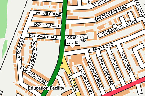
L9 0HB is located in the Fazakerley North electoral ward, within the metropolitan district of Liverpool and the English Parliamentary constituency of Liverpool, Walton. The Sub Integrated Care Board (ICB) Location is NHS Cheshire and Merseyside ICB - 99A and the police force is Merseyside. This postcode has been in use since January 1980.


GetTheData
Source: OS OpenMap – Local (Ordnance Survey)
Source: OS VectorMap District (Ordnance Survey)
Licence: Open Government Licence (requires attribution)
| Easting | 336685 |
| Northing | 397164 |
| Latitude | 53.467391 |
| Longitude | -2.955230 |
GetTheData
Source: Open Postcode Geo
Licence: Open Government Licence
| Country | England |
| Postcode District | L9 |
➜ See where L9 is on a map ➜ Where is Liverpool? | |
GetTheData
Source: Land Registry Price Paid Data
Licence: Open Government Licence
Elevation or altitude of L9 0HB as distance above sea level:
| Metres | Feet | |
|---|---|---|
| Elevation | 30m | 98ft |
Elevation is measured from the approximate centre of the postcode, to the nearest point on an OS contour line from OS Terrain 50, which has contour spacing of ten vertical metres.
➜ How high above sea level am I? Find the elevation of your current position using your device's GPS.
GetTheData
Source: Open Postcode Elevation
Licence: Open Government Licence
| Ward | Fazakerley North |
| Constituency | Liverpool, Walton |
GetTheData
Source: ONS Postcode Database
Licence: Open Government Licence
| Albany Road (Warbreck Moor) | Warbreck Park | 63m |
| Eastbourne Road (Warbreck Moor) | Fazakerley | 75m |
| Longmoor Primary School (Hall Lane) | Fazakerley | 195m |
| Church Avenue (Warbreck Moor) | Warbreck Park | 234m |
| Poulter Road (Longmoor Lane) | Fazakerley | 246m |
| Aintree Station | 0.7km |
| Orrell Park Station | 0.8km |
| Rice Lane Station | 1.2km |
GetTheData
Source: NaPTAN
Licence: Open Government Licence
GetTheData
Source: ONS Postcode Database
Licence: Open Government Licence


➜ Get more ratings from the Food Standards Agency
GetTheData
Source: Food Standards Agency
Licence: FSA terms & conditions
| Last Collection | |||
|---|---|---|---|
| Location | Mon-Fri | Sat | Distance |
| Warbreck Moor/Danehurst Road | 16:30 | 12:00 | 123m |
| Walton Vale Post Office | 16:45 | 12:00 | 420m |
| Karonga Road | 16:00 | 12:00 | 659m |
GetTheData
Source: Dracos
Licence: Creative Commons Attribution-ShareAlike
The below table lists the International Territorial Level (ITL) codes (formerly Nomenclature of Territorial Units for Statistics (NUTS) codes) and Local Administrative Units (LAU) codes for L9 0HB:
| ITL 1 Code | Name |
|---|---|
| TLD | North West (England) |
| ITL 2 Code | Name |
| TLD7 | Merseyside |
| ITL 3 Code | Name |
| TLD72 | Liverpool |
| LAU 1 Code | Name |
| E08000012 | Liverpool |
GetTheData
Source: ONS Postcode Directory
Licence: Open Government Licence
The below table lists the Census Output Area (OA), Lower Layer Super Output Area (LSOA), and Middle Layer Super Output Area (MSOA) for L9 0HB:
| Code | Name | |
|---|---|---|
| OA | E00033733 | |
| LSOA | E01006656 | Liverpool 002B |
| MSOA | E02001348 | Liverpool 002 |
GetTheData
Source: ONS Postcode Directory
Licence: Open Government Licence
| L9 0ES | Warbreck Moor | 36m |
| L9 0HD | Coerton Road | 57m |
| L9 0HA | Albany Road | 77m |
| L9 0JF | Eastbourne Road | 103m |
| L9 4RR | Warbreck Moor | 106m |
| L9 0EX | Hall Lane | 127m |
| L9 0EU | Hall Lane | 136m |
| L9 0HF | Harradon Road | 139m |
| L9 0HH | Cornett Road | 141m |
| L9 4SE | Heswall Road | 143m |
GetTheData
Source: Open Postcode Geo; Land Registry Price Paid Data
Licence: Open Government Licence