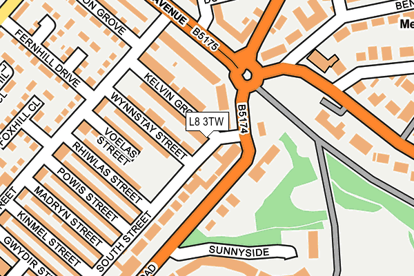
L8 3TW is located in the Toxteth electoral ward, within the metropolitan district of Liverpool and the English Parliamentary constituency of Liverpool, Riverside. The Sub Integrated Care Board (ICB) Location is NHS Cheshire and Merseyside ICB - 99A and the police force is Merseyside. This postcode has been in use since January 1980.


GetTheData
Source: OS OpenMap – Local (Ordnance Survey)
Source: OS VectorMap District (Ordnance Survey)
Licence: Open Government Licence (requires attribution)
| Easting | 336497 |
| Northing | 388496 |
| Latitude | 53.389483 |
| Longitude | -2.956311 |
GetTheData
Source: Open Postcode Geo
Licence: Open Government Licence
| Country | England |
| Postcode District | L8 |
➜ See where L8 is on a map ➜ Where is Liverpool? | |
GetTheData
Source: Land Registry Price Paid Data
Licence: Open Government Licence
Elevation or altitude of L8 3TW as distance above sea level:
| Metres | Feet | |
|---|---|---|
| Elevation | 50m | 164ft |
Elevation is measured from the approximate centre of the postcode, to the nearest point on an OS contour line from OS Terrain 50, which has contour spacing of ten vertical metres.
➜ How high above sea level am I? Find the elevation of your current position using your device's GPS.
GetTheData
Source: Open Postcode Elevation
Licence: Open Government Licence
| Ward | Toxteth |
| Constituency | Liverpool, Riverside |
GetTheData
Source: ONS Postcode Database
Licence: Open Government Licence
| Princes Gate West (Princes Park Gates) | Toxteth | 141m |
| Kingsley Road (Princes Park Gates) | Toxteth | 151m |
| High Park Street (Princes Park Gates) | Toxteth | 161m |
| Jermyn Street (Kinglsey Road) | Toxteth | 295m |
| Belvidere Road (Devonshire Road) | Princes Park | 297m |
| Brunswick Station | 1.5km |
| St Michaels Station | 1.6km |
| Edge Hill Station | 1.6km |
GetTheData
Source: NaPTAN
Licence: Open Government Licence
| Percentage of properties with Next Generation Access | 100.0% |
| Percentage of properties with Superfast Broadband | 100.0% |
| Percentage of properties with Ultrafast Broadband | 0.0% |
| Percentage of properties with Full Fibre Broadband | 0.0% |
Superfast Broadband is between 30Mbps and 300Mbps
Ultrafast Broadband is > 300Mbps
| Percentage of properties unable to receive 2Mbps | 0.0% |
| Percentage of properties unable to receive 5Mbps | 0.0% |
| Percentage of properties unable to receive 10Mbps | 0.0% |
| Percentage of properties unable to receive 30Mbps | 0.0% |
GetTheData
Source: Ofcom
Licence: Ofcom Terms of Use (requires attribution)
GetTheData
Source: ONS Postcode Database
Licence: Open Government Licence


➜ Get more ratings from the Food Standards Agency
GetTheData
Source: Food Standards Agency
Licence: FSA terms & conditions
| Last Collection | |||
|---|---|---|---|
| Location | Mon-Fri | Sat | Distance |
| Princes Gate West | 17:30 | 12:00 | 55m |
| Granby Street | 17:00 | 12:00 | 235m |
| Powis Street | 17:30 | 12:00 | 237m |
GetTheData
Source: Dracos
Licence: Creative Commons Attribution-ShareAlike
The below table lists the International Territorial Level (ITL) codes (formerly Nomenclature of Territorial Units for Statistics (NUTS) codes) and Local Administrative Units (LAU) codes for L8 3TW:
| ITL 1 Code | Name |
|---|---|
| TLD | North West (England) |
| ITL 2 Code | Name |
| TLD7 | Merseyside |
| ITL 3 Code | Name |
| TLD72 | Liverpool |
| LAU 1 Code | Name |
| E08000012 | Liverpool |
GetTheData
Source: ONS Postcode Directory
Licence: Open Government Licence
The below table lists the Census Output Area (OA), Lower Layer Super Output Area (LSOA), and Middle Layer Super Output Area (MSOA) for L8 3TW:
| Code | Name | |
|---|---|---|
| OA | E00033829 | |
| LSOA | E01006675 | Liverpool 043C |
| MSOA | E02001389 | Liverpool 043 |
GetTheData
Source: ONS Postcode Directory
Licence: Open Government Licence
| L8 3TY | Devonshire Road | 68m |
| L8 3UE | Kelvin Grove | 85m |
| L8 3TX | Devonshire Road | 106m |
| L8 0SU | Princes Gate East | 156m |
| L8 3TH | Cavendish Gardens | 188m |
| L8 3UJ | Croxteth Road | 194m |
| L8 2UL | Princes Road | 199m |
| L8 3UQ | High Park Street | 220m |
| L8 3TD | Sunnyside | 234m |
| L8 3SE | Croxteth Road | 253m |
GetTheData
Source: Open Postcode Geo; Land Registry Price Paid Data
Licence: Open Government Licence