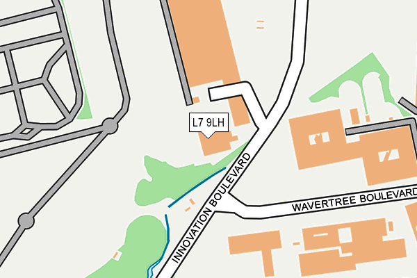
L7 9LH lies on Edge Lane in Edge Hill, Liverpool. L7 9LH is located in the Old Swan West electoral ward, within the metropolitan district of Liverpool and the English Parliamentary constituency of Liverpool, Wavertree. The Sub Integrated Care Board (ICB) Location is NHS Cheshire and Merseyside ICB - 99A and the police force is Merseyside. This postcode has been in use since January 1980.


GetTheData
Source: OS OpenMap – Local (Ordnance Survey)
Source: OS VectorMap District (Ordnance Survey)
Licence: Open Government Licence (requires attribution)
| Easting | 337721 |
| Northing | 390364 |
| Latitude | 53.406417 |
| Longitude | -2.938278 |
GetTheData
Source: Open Postcode Geo
Licence: Open Government Licence
| Street | Edge Lane |
| Locality | Edge Hill |
| Town/City | Liverpool |
| Country | England |
| Postcode District | L7 |
➜ See where L7 is on a map ➜ Where is Liverpool? | |
GetTheData
Source: Land Registry Price Paid Data
Licence: Open Government Licence
Elevation or altitude of L7 9LH as distance above sea level:
| Metres | Feet | |
|---|---|---|
| Elevation | 50m | 164ft |
Elevation is measured from the approximate centre of the postcode, to the nearest point on an OS contour line from OS Terrain 50, which has contour spacing of ten vertical metres.
➜ How high above sea level am I? Find the elevation of your current position using your device's GPS.
GetTheData
Source: Open Postcode Elevation
Licence: Open Government Licence
| Ward | Old Swan West |
| Constituency | Liverpool, Wavertree |
GetTheData
Source: ONS Postcode Database
Licence: Open Government Licence
BOTANIC LODGE, EDGE LANE, EDGE HILL, LIVERPOOL, L7 9LH 2013 8 JAN £83,000 |
GetTheData
Source: HM Land Registry Price Paid Data
Licence: Contains HM Land Registry data © Crown copyright and database right 2025. This data is licensed under the Open Government Licence v3.0.
| Wavertree Technology Park (Wavertree Boulevard) | Wavertree Technology Park | 204m |
| Wavertree Technology Park (Wavertree Boulevard) | Wavertree Technology Park | 241m |
| Laurel Road (Edge Lane) | Wavertree Technology Park | 333m |
| Laurel Road (Edge Lane) | Fairfield | 364m |
| Deane Road (Edge Lane) | Kensington | 410m |
| Edge Hill Station | 0.7km |
| Wavertree Technology Park Station | 1km |
| Liverpool Lime Street Station | 2.6km |
GetTheData
Source: NaPTAN
Licence: Open Government Licence
GetTheData
Source: ONS Postcode Database
Licence: Open Government Licence


➜ Get more ratings from the Food Standards Agency
GetTheData
Source: Food Standards Agency
Licence: FSA terms & conditions
| Last Collection | |||
|---|---|---|---|
| Location | Mon-Fri | Sat | Distance |
| Picton Road | 16:00 | 12:00 | 625m |
| Wavertree Road | 17:00 | 12:00 | 651m |
| Durning Road | 17:15 | 12:00 | 659m |
GetTheData
Source: Dracos
Licence: Creative Commons Attribution-ShareAlike
The below table lists the International Territorial Level (ITL) codes (formerly Nomenclature of Territorial Units for Statistics (NUTS) codes) and Local Administrative Units (LAU) codes for L7 9LH:
| ITL 1 Code | Name |
|---|---|
| TLD | North West (England) |
| ITL 2 Code | Name |
| TLD7 | Merseyside |
| ITL 3 Code | Name |
| TLD72 | Liverpool |
| LAU 1 Code | Name |
| E08000012 | Liverpool |
GetTheData
Source: ONS Postcode Directory
Licence: Open Government Licence
The below table lists the Census Output Area (OA), Lower Layer Super Output Area (LSOA), and Middle Layer Super Output Area (MSOA) for L7 9LH:
| Code | Name | |
|---|---|---|
| OA | E00033901 | |
| LSOA | E01006690 | Liverpool 028A |
| MSOA | E02001374 | Liverpool 028 |
GetTheData
Source: ONS Postcode Directory
Licence: Open Government Licence
| L7 0LH | Holly Road | 424m |
| L7 5PY | Botanic Road | 441m |
| L7 9LB | Edge Lane | 449m |
| L7 9LA | Garthowen Road | 449m |
| L7 9LF | Edge Lane | 449m |
| L7 5PX | Botanic Road | 451m |
| L7 5PZ | Botanic Road | 477m |
| L7 0HX | Holly Road | 478m |
| L7 5QY | Gresley Close | 479m |
| L7 9LR | Adamson Street | 479m |
GetTheData
Source: Open Postcode Geo; Land Registry Price Paid Data
Licence: Open Government Licence