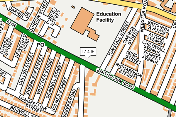
L7 4JE lies on Smithdown Road in Liverpool. L7 4JE is located in the Edge Hill electoral ward, within the metropolitan district of Liverpool and the English Parliamentary constituency of Liverpool, Wavertree. The Sub Integrated Care Board (ICB) Location is NHS Cheshire and Merseyside ICB - 99A and the police force is Merseyside. This postcode has been in use since January 1980.


GetTheData
Source: OS OpenMap – Local (Ordnance Survey)
Source: OS VectorMap District (Ordnance Survey)
Licence: Open Government Licence (requires attribution)
| Easting | 337336 |
| Northing | 389305 |
| Latitude | 53.396837 |
| Longitude | -2.943858 |
GetTheData
Source: Open Postcode Geo
Licence: Open Government Licence
| Street | Smithdown Road |
| Town/City | Liverpool |
| Country | England |
| Postcode District | L7 |
➜ See where L7 is on a map ➜ Where is Liverpool? | |
GetTheData
Source: Land Registry Price Paid Data
Licence: Open Government Licence
Elevation or altitude of L7 4JE as distance above sea level:
| Metres | Feet | |
|---|---|---|
| Elevation | 50m | 164ft |
Elevation is measured from the approximate centre of the postcode, to the nearest point on an OS contour line from OS Terrain 50, which has contour spacing of ten vertical metres.
➜ How high above sea level am I? Find the elevation of your current position using your device's GPS.
GetTheData
Source: Open Postcode Elevation
Licence: Open Government Licence
| Ward | Edge Hill |
| Constituency | Liverpool, Wavertree |
GetTheData
Source: ONS Postcode Database
Licence: Open Government Licence
| Wendell Street (Smithdown Road) | Wavertree | 45m |
| Garrick Street (Smithdown Road) | Edge Hill | 86m |
| Garrick Street (Smithdown Road) | Sefton Park | 109m |
| Annerley Street (Earle Road) | Edge Hill | 233m |
| Salisbury Road (Smithdown Road) | Wavertree | 303m |
| Edge Hill Station | 0.7km |
| Wavertree Technology Park Station | 1.7km |
| St Michaels Station | 2.4km |
GetTheData
Source: NaPTAN
Licence: Open Government Licence
GetTheData
Source: ONS Postcode Database
Licence: Open Government Licence


➜ Get more ratings from the Food Standards Agency
GetTheData
Source: Food Standards Agency
Licence: FSA terms & conditions
| Last Collection | |||
|---|---|---|---|
| Location | Mon-Fri | Sat | Distance |
| Smithdown Road Post Office | 17:30 | 12:00 | 144m |
| Alderson Road | 16:00 | 12:00 | 336m |
| Boswell Street | 17:15 | 12:00 | 390m |
GetTheData
Source: Dracos
Licence: Creative Commons Attribution-ShareAlike
The below table lists the International Territorial Level (ITL) codes (formerly Nomenclature of Territorial Units for Statistics (NUTS) codes) and Local Administrative Units (LAU) codes for L7 4JE:
| ITL 1 Code | Name |
|---|---|
| TLD | North West (England) |
| ITL 2 Code | Name |
| TLD7 | Merseyside |
| ITL 3 Code | Name |
| TLD72 | Liverpool |
| LAU 1 Code | Name |
| E08000012 | Liverpool |
GetTheData
Source: ONS Postcode Directory
Licence: Open Government Licence
The below table lists the Census Output Area (OA), Lower Layer Super Output Area (LSOA), and Middle Layer Super Output Area (MSOA) for L7 4JE:
| Code | Name | |
|---|---|---|
| OA | E00176648 | |
| LSOA | E01006752 | Liverpool 035F |
| MSOA | E02001381 | Liverpool 035 |
GetTheData
Source: ONS Postcode Directory
Licence: Open Government Licence
| L7 4JQ | Smithdown Road | 81m |
| L8 0RH | Holmes Street | 122m |
| L7 4LF | Garrick Street | 122m |
| L7 4LE | Garrick Street | 135m |
| L8 0RJ | Holmes Street | 139m |
| L7 4LH | Richardson Street | 140m |
| L8 0RG | Wendell Street | 145m |
| L7 4JF | Smithdown Road | 145m |
| L7 4LD | Bird Street | 150m |
| L8 0RD | Lesseps Road | 152m |
GetTheData
Source: Open Postcode Geo; Land Registry Price Paid Data
Licence: Open Government Licence