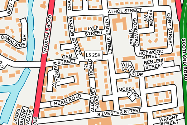
L5 2SX is located in the Vauxhall electoral ward, within the metropolitan district of Liverpool and the English Parliamentary constituency of Liverpool, Riverside. The Sub Integrated Care Board (ICB) Location is NHS Cheshire and Merseyside ICB - 99A and the police force is Merseyside. This postcode has been in use since June 1996.


GetTheData
Source: OS OpenMap – Local (Ordnance Survey)
Source: OS VectorMap District (Ordnance Survey)
Licence: Open Government Licence (requires attribution)
| Easting | 334548 |
| Northing | 392240 |
| Latitude | 53.422893 |
| Longitude | -2.986390 |
GetTheData
Source: Open Postcode Geo
Licence: Open Government Licence
| Country | England |
| Postcode District | L5 |
➜ See where L5 is on a map ➜ Where is Liverpool? | |
GetTheData
Source: Land Registry Price Paid Data
Licence: Open Government Licence
Elevation or altitude of L5 2SX as distance above sea level:
| Metres | Feet | |
|---|---|---|
| Elevation | 20m | 66ft |
Elevation is measured from the approximate centre of the postcode, to the nearest point on an OS contour line from OS Terrain 50, which has contour spacing of ten vertical metres.
➜ How high above sea level am I? Find the elevation of your current position using your device's GPS.
GetTheData
Source: Open Postcode Elevation
Licence: Open Government Licence
| Ward | Vauxhall |
| Constituency | Liverpool, Riverside |
GetTheData
Source: ONS Postcode Database
Licence: Open Government Licence
| Mckeown Close (Latimer Street) | Kirkdale | 115m |
| Athol Street (Latimer Street) | Kirkdale | 140m |
| Silvester Street (Latimer Street) | Kirkdale | 145m |
| Lyle Street (Latimer Street) | Kirkdale | 146m |
| Alderney Road (Silvester Street) | Kirkdale | 158m |
| Sandhills Station | 0.9km |
| Moorfields Station | 1.6km |
| Bank Hall Station | 1.6km |
GetTheData
Source: NaPTAN
Licence: Open Government Licence
| Percentage of properties with Next Generation Access | 100.0% |
| Percentage of properties with Superfast Broadband | 100.0% |
| Percentage of properties with Ultrafast Broadband | 100.0% |
| Percentage of properties with Full Fibre Broadband | 0.0% |
Superfast Broadband is between 30Mbps and 300Mbps
Ultrafast Broadband is > 300Mbps
| Percentage of properties unable to receive 2Mbps | 0.0% |
| Percentage of properties unable to receive 5Mbps | 0.0% |
| Percentage of properties unable to receive 10Mbps | 0.0% |
| Percentage of properties unable to receive 30Mbps | 0.0% |
GetTheData
Source: Ofcom
Licence: Ofcom Terms of Use (requires attribution)
GetTheData
Source: ONS Postcode Database
Licence: Open Government Licence


➜ Get more ratings from the Food Standards Agency
GetTheData
Source: Food Standards Agency
Licence: FSA terms & conditions
| Last Collection | |||
|---|---|---|---|
| Location | Mon-Fri | Sat | Distance |
| Lightbody Street | 17:15 | 12:00 | 665m |
| Great Howard Street | 18:15 | 12:00 | 800m |
| Heyworth Street | 16:30 | 12:00 | 1,124m |
GetTheData
Source: Dracos
Licence: Creative Commons Attribution-ShareAlike
The below table lists the International Territorial Level (ITL) codes (formerly Nomenclature of Territorial Units for Statistics (NUTS) codes) and Local Administrative Units (LAU) codes for L5 2SX:
| ITL 1 Code | Name |
|---|---|
| TLD | North West (England) |
| ITL 2 Code | Name |
| TLD7 | Merseyside |
| ITL 3 Code | Name |
| TLD72 | Liverpool |
| LAU 1 Code | Name |
| E08000012 | Liverpool |
GetTheData
Source: ONS Postcode Directory
Licence: Open Government Licence
The below table lists the Census Output Area (OA), Lower Layer Super Output Area (LSOA), and Middle Layer Super Output Area (MSOA) for L5 2SX:
| Code | Name | |
|---|---|---|
| OA | E00034374 | |
| LSOA | E01006779 | Liverpool 022D |
| MSOA | E02001368 | Liverpool 022 |
GetTheData
Source: ONS Postcode Directory
Licence: Open Government Licence
| L5 2RZ | Bangor Street | 33m |
| L5 8SU | Latimer Street | 53m |
| L5 8YD | Callaghan Close | 99m |
| L5 2AR | Marnell Close | 109m |
| L5 2AT | Gem Street | 111m |
| L5 2RY | Bangor Street | 134m |
| L5 2SY | Vauxhall Road | 152m |
| L5 8YE | Mckeown Close | 152m |
| L5 2QY | Athol Street | 154m |
| L5 2BD | Vauxhall Road | 160m |
GetTheData
Source: Open Postcode Geo; Land Registry Price Paid Data
Licence: Open Government Licence