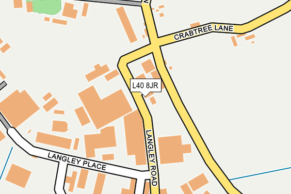
L40 8JR lies on Langley Road in Burscough Industrial Estate, Ormskirk. L40 8JR is located in the Burscough Bridge & Rufford electoral ward, within the local authority district of West Lancashire and the English Parliamentary constituency of West Lancashire. The Sub Integrated Care Board (ICB) Location is NHS Lancashire and South Cumbria ICB - 02G and the police force is Lancashire. This postcode has been in use since June 1981.


GetTheData
Source: OS OpenMap – Local (Ordnance Survey)
Source: OS VectorMap District (Ordnance Survey)
Licence: Open Government Licence (requires attribution)
| Easting | 342807 |
| Northing | 411873 |
| Latitude | 53.600303 |
| Longitude | -2.865714 |
GetTheData
Source: Open Postcode Geo
Licence: Open Government Licence
| Street | Langley Road |
| Locality | Burscough Industrial Estate |
| Town/City | Ormskirk |
| Country | England |
| Postcode District | L40 |
➜ See where L40 is on a map ➜ Where is Burscough? | |
GetTheData
Source: Land Registry Price Paid Data
Licence: Open Government Licence
Elevation or altitude of L40 8JR as distance above sea level:
| Metres | Feet | |
|---|---|---|
| Elevation | 20m | 66ft |
Elevation is measured from the approximate centre of the postcode, to the nearest point on an OS contour line from OS Terrain 50, which has contour spacing of ten vertical metres.
➜ How high above sea level am I? Find the elevation of your current position using your device's GPS.
GetTheData
Source: Open Postcode Elevation
Licence: Open Government Licence
| Ward | Burscough Bridge & Rufford |
| Constituency | West Lancashire |
GetTheData
Source: ONS Postcode Database
Licence: Open Government Licence
EUROPEAN WOOD PRODUCTS LTD, LANGLEY ROAD, BURSCOUGH INDUSTRIAL ESTATE, ORMSKIRK, L40 8JR 1998 24 NOV £250,000 |
GetTheData
Source: HM Land Registry Price Paid Data
Licence: Contains HM Land Registry data © Crown copyright and database right 2025. This data is licensed under the Open Government Licence v3.0.
| Higgins Lane (Hesketh Road) | Burscough | 892m |
| Hesketh Road (Truscott Road) | Burscough | 1,123m |
| Truscott Road | Burscough | 1,130m |
| Priory High School (Vicarage Gardens) | Burscough | 1,164m |
| Higgins Lane | Burscough | 1,240m |
| New Lane Station | 1.3km |
| Burscough Junction Station | 1.7km |
| Burscough Bridge Station | 1.7km |
GetTheData
Source: NaPTAN
Licence: Open Government Licence
GetTheData
Source: ONS Postcode Database
Licence: Open Government Licence


➜ Get more ratings from the Food Standards Agency
GetTheData
Source: Food Standards Agency
Licence: FSA terms & conditions
| Last Collection | |||
|---|---|---|---|
| Location | Mon-Fri | Sat | Distance |
| Burscough Junction | 17:30 | 12:00 | 1,709m |
| Rufford Post Office | 16:45 | 11:30 | 3,001m |
| Hall Lane | 13:00 | 08:00 | 3,767m |
GetTheData
Source: Dracos
Licence: Creative Commons Attribution-ShareAlike
The below table lists the International Territorial Level (ITL) codes (formerly Nomenclature of Territorial Units for Statistics (NUTS) codes) and Local Administrative Units (LAU) codes for L40 8JR:
| ITL 1 Code | Name |
|---|---|
| TLD | North West (England) |
| ITL 2 Code | Name |
| TLD4 | Lancashire |
| ITL 3 Code | Name |
| TLD47 | Chorley and West Lancashire |
| LAU 1 Code | Name |
| E07000127 | West Lancashire |
GetTheData
Source: ONS Postcode Directory
Licence: Open Government Licence
The below table lists the Census Output Area (OA), Lower Layer Super Output Area (LSOA), and Middle Layer Super Output Area (MSOA) for L40 8JR:
| Code | Name | |
|---|---|---|
| OA | E00129347 | |
| LSOA | E01025487 | West Lancashire 004E |
| MSOA | E02005307 | West Lancashire 004 |
GetTheData
Source: ONS Postcode Directory
Licence: Open Government Licence
| L40 8JW | Swordfish Close | 90m |
| L40 8JB | Higgins Lane | 242m |
| L40 8JT | Plantation Road | 263m |
| L40 8JY | Ringtail Road | 274m |
| L40 8LA | Ringtail Place | 379m |
| L40 8JA | New Lane | 521m |
| L40 0RN | Crabtree Lane | 572m |
| L40 0RR | Canal Bank | 758m |
| L40 7UX | Abbey Fold | 837m |
| L40 8LD | Tollgate Road | 864m |
GetTheData
Source: Open Postcode Geo; Land Registry Price Paid Data
Licence: Open Government Licence