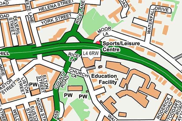
L4 6RW is located in the County electoral ward, within the metropolitan district of Liverpool and the English Parliamentary constituency of Liverpool, Walton. The Sub Integrated Care Board (ICB) Location is NHS Cheshire and Merseyside ICB - 99A and the police force is Merseyside. This postcode has been in use since January 2008.


GetTheData
Source: OS OpenMap – Local (Ordnance Survey)
Source: OS VectorMap District (Ordnance Survey)
Licence: Open Government Licence (requires attribution)
| Easting | 335934 |
| Northing | 394920 |
| Latitude | 53.447132 |
| Longitude | -2.966083 |
GetTheData
Source: Open Postcode Geo
Licence: Open Government Licence
| Country | England |
| Postcode District | L4 |
➜ See where L4 is on a map ➜ Where is Liverpool? | |
GetTheData
Source: Land Registry Price Paid Data
Licence: Open Government Licence
Elevation or altitude of L4 6RW as distance above sea level:
| Metres | Feet | |
|---|---|---|
| Elevation | 40m | 131ft |
Elevation is measured from the approximate centre of the postcode, to the nearest point on an OS contour line from OS Terrain 50, which has contour spacing of ten vertical metres.
➜ How high above sea level am I? Find the elevation of your current position using your device's GPS.
GetTheData
Source: Open Postcode Elevation
Licence: Open Government Licence
| Ward | County |
| Constituency | Liverpool, Walton |
GetTheData
Source: ONS Postcode Database
Licence: Open Government Licence
| Rice Lane (Queens Drive) | Walton On The Hill | 51m |
| Moor Lane (Queens Drive) | Walton | 70m |
| Breeze Hill (County Road) | Walton On The Hill | 128m |
| Walton Church (County Road) | Walton On The Hill | 135m |
| York Street (Rice Lane) | Walton | 147m |
| Walton (Merseyside) Station | 1km |
| Rice Lane Station | 1.2km |
| Kirkdale Station | 1.2km |
GetTheData
Source: NaPTAN
Licence: Open Government Licence
GetTheData
Source: ONS Postcode Database
Licence: Open Government Licence


➜ Get more ratings from the Food Standards Agency
GetTheData
Source: Food Standards Agency
Licence: FSA terms & conditions
| Last Collection | |||
|---|---|---|---|
| Location | Mon-Fri | Sat | Distance |
| Cavendish Drive | 16:00 | 12:00 | 541m |
| Rice Lane | 16:00 | 12:00 | 903m |
| County Road Post Office | 17:00 | 12:00 | 997m |
GetTheData
Source: Dracos
Licence: Creative Commons Attribution-ShareAlike
The below table lists the International Territorial Level (ITL) codes (formerly Nomenclature of Territorial Units for Statistics (NUTS) codes) and Local Administrative Units (LAU) codes for L4 6RW:
| ITL 1 Code | Name |
|---|---|
| TLD | North West (England) |
| ITL 2 Code | Name |
| TLD7 | Merseyside |
| ITL 3 Code | Name |
| TLD72 | Liverpool |
| LAU 1 Code | Name |
| E08000012 | Liverpool |
GetTheData
Source: ONS Postcode Directory
Licence: Open Government Licence
The below table lists the Census Output Area (OA), Lower Layer Super Output Area (LSOA), and Middle Layer Super Output Area (MSOA) for L4 6RW:
| Code | Name | |
|---|---|---|
| OA | E00033483 | |
| LSOA | E01006610 | Liverpool 009C |
| MSOA | E02001355 | Liverpool 009 |
GetTheData
Source: ONS Postcode Directory
Licence: Open Government Licence
| L4 5PQ | County Road | 132m |
| L4 5RU | Elton Street | 168m |
| L9 1BN | York Street | 173m |
| L9 1BW | York Street | 191m |
| L4 6TJ | Walton Village | 194m |
| L9 1ED | Denbigh Road | 208m |
| L9 1BH | Helena Street | 209m |
| L9 1DY | Breeze Hill | 210m |
| L9 1EB | Carnarvon Road | 224m |
| L4 5PE | County Road | 226m |
GetTheData
Source: Open Postcode Geo; Land Registry Price Paid Data
Licence: Open Government Licence