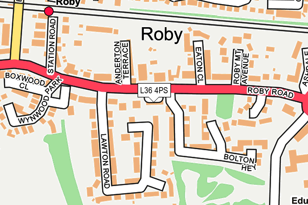
L36 4PS lies on Colin Close in Liverpool. L36 4PS is located in the Roby electoral ward, within the metropolitan district of Knowsley and the English Parliamentary constituency of Knowsley. The Sub Integrated Care Board (ICB) Location is NHS Cheshire and Merseyside ICB - 01J and the police force is Merseyside. This postcode has been in use since January 1980.


GetTheData
Source: OS OpenMap – Local (Ordnance Survey)
Source: OS VectorMap District (Ordnance Survey)
Licence: Open Government Licence (requires attribution)
| Easting | 343419 |
| Northing | 390518 |
| Latitude | 53.408428 |
| Longitude | -2.852607 |
GetTheData
Source: Open Postcode Geo
Licence: Open Government Licence
| Street | Colin Close |
| Town/City | Liverpool |
| Country | England |
| Postcode District | L36 |
➜ See where L36 is on a map ➜ Where is Huyton with Roby? | |
GetTheData
Source: Land Registry Price Paid Data
Licence: Open Government Licence
Elevation or altitude of L36 4PS as distance above sea level:
| Metres | Feet | |
|---|---|---|
| Elevation | 40m | 131ft |
Elevation is measured from the approximate centre of the postcode, to the nearest point on an OS contour line from OS Terrain 50, which has contour spacing of ten vertical metres.
➜ How high above sea level am I? Find the elevation of your current position using your device's GPS.
GetTheData
Source: Open Postcode Elevation
Licence: Open Government Licence
| Ward | Roby |
| Constituency | Knowsley |
GetTheData
Source: ONS Postcode Database
Licence: Open Government Licence
| Anderton Terrace (Roby Road) | Roby | 78m |
| Lawton Road (Roby Road) | Roby | 139m |
| Waterside Park (Roby Road) | Roby | 181m |
| Station Road (Roby Road) | Roby | 246m |
| Blacklow Brow (Tarbock Road) | Blacklow Brow | 350m |
| Roby Station | 0.3km |
| Huyton Station | 0.7km |
| Broad Green Station | 2.7km |
GetTheData
Source: NaPTAN
Licence: Open Government Licence
| Median download speed | 39.5Mbps |
| Average download speed | 32.2Mbps |
| Maximum download speed | 42.56Mbps |
| Median upload speed | 6.6Mbps |
| Average upload speed | 5.3Mbps |
| Maximum upload speed | 8.62Mbps |
GetTheData
Source: Ofcom
Licence: Ofcom Terms of Use (requires attribution)
Estimated total energy consumption in L36 4PS by fuel type, 2015.
| Consumption (kWh) | 116,749 |
|---|---|
| Meter count | 7 |
| Mean (kWh/meter) | 16,678 |
| Median (kWh/meter) | 16,853 |
| Consumption (kWh) | 26,084 |
|---|---|
| Meter count | 6 |
| Mean (kWh/meter) | 4,347 |
| Median (kWh/meter) | 4,000 |
GetTheData
Source: Postcode level gas estimates: 2015 (experimental)
Source: Postcode level electricity estimates: 2015 (experimental)
Licence: Open Government Licence
GetTheData
Source: ONS Postcode Database
Licence: Open Government Licence


➜ Get more ratings from the Food Standards Agency
GetTheData
Source: Food Standards Agency
Licence: FSA terms & conditions
| Last Collection | |||
|---|---|---|---|
| Location | Mon-Fri | Sat | Distance |
| Huyton Post Office | 17:45 | 12:00 | 931m |
| Gladstone Avenue | 16:15 | 12:00 | 1,254m |
| Courthey Park | 16:15 | 12:00 | 1,322m |
GetTheData
Source: Dracos
Licence: Creative Commons Attribution-ShareAlike
The below table lists the International Territorial Level (ITL) codes (formerly Nomenclature of Territorial Units for Statistics (NUTS) codes) and Local Administrative Units (LAU) codes for L36 4PS:
| ITL 1 Code | Name |
|---|---|
| TLD | North West (England) |
| ITL 2 Code | Name |
| TLD7 | Merseyside |
| ITL 3 Code | Name |
| TLD71 | East Merseyside |
| LAU 1 Code | Name |
| E08000011 | Knowsley |
GetTheData
Source: ONS Postcode Directory
Licence: Open Government Licence
The below table lists the Census Output Area (OA), Lower Layer Super Output Area (LSOA), and Middle Layer Super Output Area (MSOA) for L36 4PS:
| Code | Name | |
|---|---|---|
| OA | E00032805 | |
| LSOA | E01006473 | Knowsley 016B |
| MSOA | E02001342 | Knowsley 016 |
GetTheData
Source: ONS Postcode Directory
Licence: Open Government Licence
| L36 4HF | Roby Road | 69m |
| L36 4HS | Anderton Terrace | 102m |
| L36 4HN | Lawton Road | 120m |
| L36 4HW | Lawton Road | 123m |
| L36 4HA | Roby Road | 126m |
| L36 4HR | Eaton Close | 129m |
| L36 4HL | Lawton Road | 165m |
| L36 4RN | Waterside Park | 194m |
| L36 4HE | Roby Road | 198m |
| L36 4HP | Roby Mount Avenue | 205m |
GetTheData
Source: Open Postcode Geo; Land Registry Price Paid Data
Licence: Open Government Licence