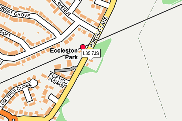
L35 7JS lies on Portico Lane in Prescot. L35 7JS is located in the Eccleston electoral ward, within the metropolitan district of St. Helens and the English Parliamentary constituency of St Helens South and Whiston. The Sub Integrated Care Board (ICB) Location is NHS Cheshire and Merseyside ICB - 01X and the police force is Merseyside. This postcode has been in use since January 1980.


GetTheData
Source: OS OpenMap – Local (Ordnance Survey)
Source: OS VectorMap District (Ordnance Survey)
Licence: Open Government Licence (requires attribution)
| Easting | 348290 |
| Northing | 392904 |
| Latitude | 53.430373 |
| Longitude | -2.779733 |
GetTheData
Source: Open Postcode Geo
Licence: Open Government Licence
| Street | Portico Lane |
| Town/City | Prescot |
| Country | England |
| Postcode District | L35 |
➜ See where L35 is on a map ➜ Where is St Helens? | |
GetTheData
Source: Land Registry Price Paid Data
Licence: Open Government Licence
Elevation or altitude of L35 7JS as distance above sea level:
| Metres | Feet | |
|---|---|---|
| Elevation | 70m | 230ft |
Elevation is measured from the approximate centre of the postcode, to the nearest point on an OS contour line from OS Terrain 50, which has contour spacing of ten vertical metres.
➜ How high above sea level am I? Find the elevation of your current position using your device's GPS.
GetTheData
Source: Open Postcode Elevation
Licence: Open Government Licence
| Ward | Eccleston |
| Constituency | St Helens South And Whiston |
GetTheData
Source: ONS Postcode Database
Licence: Open Government Licence
| Portico Avenue (Portico Lane) | Eccleston Park | 71m |
| Portico Avenue (Portico Lane) | Eccleston Park | 128m |
| Middlehurst Close (Portico Lane) | Eccleston Park | 186m |
| Plum Tree Close (Old Lane) | Eccleston Park | 322m |
| Portico Lane (Old Lane) | Prescot | 355m |
| Eccleston Park Station | 0.1km |
| Prescot Station | 1.5km |
| Thatto Heath Station | 1.5km |
GetTheData
Source: NaPTAN
Licence: Open Government Licence
| Percentage of properties with Next Generation Access | 100.0% |
| Percentage of properties with Superfast Broadband | 100.0% |
| Percentage of properties with Ultrafast Broadband | 0.0% |
| Percentage of properties with Full Fibre Broadband | 0.0% |
Superfast Broadband is between 30Mbps and 300Mbps
Ultrafast Broadband is > 300Mbps
| Percentage of properties unable to receive 2Mbps | 0.0% |
| Percentage of properties unable to receive 5Mbps | 0.0% |
| Percentage of properties unable to receive 10Mbps | 0.0% |
| Percentage of properties unable to receive 30Mbps | 0.0% |
GetTheData
Source: Ofcom
Licence: Ofcom Terms of Use (requires attribution)
GetTheData
Source: ONS Postcode Database
Licence: Open Government Licence


➜ Get more ratings from the Food Standards Agency
GetTheData
Source: Food Standards Agency
Licence: FSA terms & conditions
| Last Collection | |||
|---|---|---|---|
| Location | Mon-Fri | Sat | Distance |
| Beechwood Grove | 17:15 | 12:00 | 1,245m |
| Nutgrove Road Post Office | 17:30 | 12:00 | 1,555m |
| Prescot Station | 17:30 | 12:00 | 1,647m |
GetTheData
Source: Dracos
Licence: Creative Commons Attribution-ShareAlike
The below table lists the International Territorial Level (ITL) codes (formerly Nomenclature of Territorial Units for Statistics (NUTS) codes) and Local Administrative Units (LAU) codes for L35 7JS:
| ITL 1 Code | Name |
|---|---|
| TLD | North West (England) |
| ITL 2 Code | Name |
| TLD7 | Merseyside |
| ITL 3 Code | Name |
| TLD71 | East Merseyside |
| LAU 1 Code | Name |
| E08000013 | St. Helens |
GetTheData
Source: ONS Postcode Directory
Licence: Open Government Licence
The below table lists the Census Output Area (OA), Lower Layer Super Output Area (LSOA), and Middle Layer Super Output Area (MSOA) for L35 7JS:
| Code | Name | |
|---|---|---|
| OA | E00034611 | |
| LSOA | E01006827 | St. Helens 018B |
| MSOA | E02001423 | St. Helens 018 |
GetTheData
Source: ONS Postcode Directory
Licence: Open Government Licence
| L35 7LP | Portico Court | 120m |
| L35 7JL | Portico Avenue | 139m |
| L34 2RP | Fairholme Avenue | 172m |
| L35 7LR | Georgian Close | 182m |
| L34 2QU | Middlehurst Close | 201m |
| L35 7JW | Portico Lane | 206m |
| L35 7JT | Plumtree Close | 251m |
| L34 2QR | Holme Close | 268m |
| L34 2QX | Orchard Close | 269m |
| L34 2QS | Portico Lane | 272m |
GetTheData
Source: Open Postcode Geo; Land Registry Price Paid Data
Licence: Open Government Licence