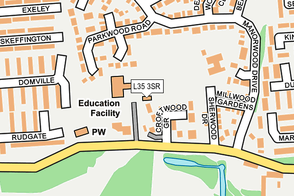
L35 3SR lies on Lickers Lane in Whiston, Prescot. L35 3SR is located in the Whiston and Cronton electoral ward, within the metropolitan district of Knowsley and the English Parliamentary constituency of St Helens South and Whiston. The Sub Integrated Care Board (ICB) Location is NHS Cheshire and Merseyside ICB - 01J and the police force is Merseyside. This postcode has been in use since January 1980.


GetTheData
Source: OS OpenMap – Local (Ordnance Survey)
Source: OS VectorMap District (Ordnance Survey)
Licence: Open Government Licence (requires attribution)
| Easting | 347443 |
| Northing | 390651 |
| Latitude | 53.410056 |
| Longitude | -2.792102 |
GetTheData
Source: Open Postcode Geo
Licence: Open Government Licence
| Street | Lickers Lane |
| Locality | Whiston |
| Town/City | Prescot |
| Country | England |
| Postcode District | L35 |
➜ See where L35 is on a map ➜ Where is Prescot? | |
GetTheData
Source: Land Registry Price Paid Data
Licence: Open Government Licence
Elevation or altitude of L35 3SR as distance above sea level:
| Metres | Feet | |
|---|---|---|
| Elevation | 50m | 164ft |
Elevation is measured from the approximate centre of the postcode, to the nearest point on an OS contour line from OS Terrain 50, which has contour spacing of ten vertical metres.
➜ How high above sea level am I? Find the elevation of your current position using your device's GPS.
GetTheData
Source: Open Postcode Elevation
Licence: Open Government Licence
| Ward | Whiston And Cronton |
| Constituency | St Helens South And Whiston |
GetTheData
Source: ONS Postcode Database
Licence: Open Government Licence
THE CARETAKER'S LODGE, ST. LEOS RC PRIMARY SCHOOL, LICKERS LANE, WHISTON, PRESCOT, L35 3SR 2014 17 JAN £158,000 |
GetTheData
Source: HM Land Registry Price Paid Data
Licence: Contains HM Land Registry data © Crown copyright and database right 2025. This data is licensed under the Open Government Licence v3.0.
| Croftwood Grove (Lickers Lane) | Whiston | 112m |
| Croftwood Grove (Lickers Lane) | Halsnead Park | 134m |
| Domville (Driveway) | Halsnead Park | 332m |
| Domville (Driveway) | Halsnead Park | 350m |
| Driveway (Cumber Lane) | Whiston | 451m |
| Whiston Station | 0.5km |
| Prescot Station | 1.6km |
| Rainhill Station | 1.9km |
GetTheData
Source: NaPTAN
Licence: Open Government Licence
GetTheData
Source: ONS Postcode Database
Licence: Open Government Licence


➜ Get more ratings from the Food Standards Agency
GetTheData
Source: Food Standards Agency
Licence: FSA terms & conditions
| Last Collection | |||
|---|---|---|---|
| Location | Mon-Fri | Sat | Distance |
| Halsnead Avenue | 16:30 | 11:30 | 1,159m |
| Beechwood Grove | 17:15 | 12:00 | 1,356m |
| Prescot Station | 17:30 | 12:00 | 1,989m |
GetTheData
Source: Dracos
Licence: Creative Commons Attribution-ShareAlike
The below table lists the International Territorial Level (ITL) codes (formerly Nomenclature of Territorial Units for Statistics (NUTS) codes) and Local Administrative Units (LAU) codes for L35 3SR:
| ITL 1 Code | Name |
|---|---|
| TLD | North West (England) |
| ITL 2 Code | Name |
| TLD7 | Merseyside |
| ITL 3 Code | Name |
| TLD71 | East Merseyside |
| LAU 1 Code | Name |
| E08000011 | Knowsley |
GetTheData
Source: ONS Postcode Directory
Licence: Open Government Licence
The below table lists the Census Output Area (OA), Lower Layer Super Output Area (LSOA), and Middle Layer Super Output Area (MSOA) for L35 3SR:
| Code | Name | |
|---|---|---|
| OA | E00032956 | |
| LSOA | E01006501 | Knowsley 013C |
| MSOA | E02001339 | Knowsley 013 |
GetTheData
Source: ONS Postcode Directory
Licence: Open Government Licence
| L35 3UT | Croftwood Grove | 71m |
| L35 3XE | Deepwood Grove | 115m |
| L35 3XB | Parkwood Road | 143m |
| L35 3XZ | Sherwood Drive | 147m |
| L35 3UU | Manorwood Drive | 170m |
| L35 3RL | Glenwood Close | 181m |
| L35 3RR | Millwood Gardens | 183m |
| L35 3XF | Earlwood Gardens | 196m |
| L35 3RP | Manorwood Drive | 211m |
| L35 3XD | Heywood Gardens | 214m |
GetTheData
Source: Open Postcode Geo; Land Registry Price Paid Data
Licence: Open Government Licence