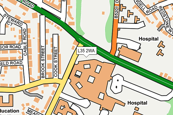
L35 2WA is located in the Whiston and Cronton electoral ward, within the metropolitan district of Knowsley and the English Parliamentary constituency of St Helens South and Whiston. The Sub Integrated Care Board (ICB) Location is NHS Cheshire and Merseyside ICB - 01J and the police force is Merseyside. This postcode has been in use since August 2006.


GetTheData
Source: OS OpenMap – Local (Ordnance Survey)
Source: OS VectorMap District (Ordnance Survey)
Licence: Open Government Licence (requires attribution)
| Easting | 347840 |
| Northing | 391949 |
| Latitude | 53.421745 |
| Longitude | -2.786347 |
GetTheData
Source: Open Postcode Geo
Licence: Open Government Licence
| Country | England |
| Postcode District | L35 |
➜ See where L35 is on a map ➜ Where is Prescot? | |
GetTheData
Source: Land Registry Price Paid Data
Licence: Open Government Licence
Elevation or altitude of L35 2WA as distance above sea level:
| Metres | Feet | |
|---|---|---|
| Elevation | 70m | 230ft |
Elevation is measured from the approximate centre of the postcode, to the nearest point on an OS contour line from OS Terrain 50, which has contour spacing of ten vertical metres.
➜ How high above sea level am I? Find the elevation of your current position using your device's GPS.
GetTheData
Source: Open Postcode Elevation
Licence: Open Government Licence
| Ward | Whiston And Cronton |
| Constituency | St Helens South And Whiston |
GetTheData
Source: ONS Postcode Database
Licence: Open Government Licence
| Warrington Road (Dragon Lane) | Whiston | 34m |
| Dragon Lane (Warrington Road) | Prescot | 34m |
| Delph Lane (Warrington Road) | Prescot | 53m |
| Shaw Lane (Dragon Lane) | Whiston | 79m |
| Cable Road (Shaw Lane) | Prescot | 201m |
| Prescot Station | 0.9km |
| Eccleston Park Station | 1.1km |
| Whiston Station | 1.1km |
GetTheData
Source: NaPTAN
Licence: Open Government Licence
GetTheData
Source: ONS Postcode Database
Licence: Open Government Licence


➜ Get more ratings from the Food Standards Agency
GetTheData
Source: Food Standards Agency
Licence: FSA terms & conditions
| Last Collection | |||
|---|---|---|---|
| Location | Mon-Fri | Sat | Distance |
| Beechwood Grove | 17:15 | 12:00 | 418m |
| Prescot Station | 17:30 | 12:00 | 1,268m |
| Police Station/ High Street | 17:30 | 12:00 | 1,731m |
GetTheData
Source: Dracos
Licence: Creative Commons Attribution-ShareAlike
The below table lists the International Territorial Level (ITL) codes (formerly Nomenclature of Territorial Units for Statistics (NUTS) codes) and Local Administrative Units (LAU) codes for L35 2WA:
| ITL 1 Code | Name |
|---|---|
| TLD | North West (England) |
| ITL 2 Code | Name |
| TLD7 | Merseyside |
| ITL 3 Code | Name |
| TLD71 | East Merseyside |
| LAU 1 Code | Name |
| E08000011 | Knowsley |
GetTheData
Source: ONS Postcode Directory
Licence: Open Government Licence
The below table lists the Census Output Area (OA), Lower Layer Super Output Area (LSOA), and Middle Layer Super Output Area (MSOA) for L35 2WA:
| Code | Name | |
|---|---|---|
| OA | E00032926 | |
| LSOA | E01006499 | Knowsley 009E |
| MSOA | E02001335 | Knowsley 009 |
GetTheData
Source: ONS Postcode Directory
Licence: Open Government Licence
| L35 2UJ | Cook Street | 109m |
| L35 5AP | Brook Street | 164m |
| L35 5AW | Cable Road | 198m |
| L35 2UF | Dragon Lane | 204m |
| L35 5AN | Cable Road | 233m |
| L35 5AF | Warrington Road | 241m |
| L35 7JP | Blundell Road | 243m |
| L35 7JH | Fire Station Road | 249m |
| L35 5AJ | Edward Road | 260m |
| L35 5AT | Shaw Lane | 264m |
GetTheData
Source: Open Postcode Geo; Land Registry Price Paid Data
Licence: Open Government Licence