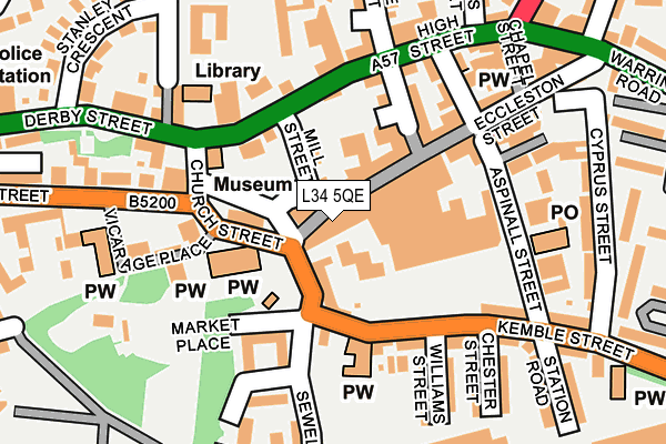
L34 5QE is located in the Prescot North electoral ward, within the metropolitan district of Knowsley and the English Parliamentary constituency of St Helens South and Whiston. The Sub Integrated Care Board (ICB) Location is NHS Cheshire and Merseyside ICB - 01J and the police force is Merseyside. This postcode has been in use since January 1980.


GetTheData
Source: OS OpenMap – Local (Ordnance Survey)
Source: OS VectorMap District (Ordnance Survey)
Licence: Open Government Licence (requires attribution)
| Easting | 346618 |
| Northing | 392731 |
| Latitude | 53.428667 |
| Longitude | -2.804865 |
GetTheData
Source: Open Postcode Geo
Licence: Open Government Licence
| Country | England |
| Postcode District | L34 |
➜ See where L34 is on a map ➜ Where is Prescot? | |
GetTheData
Source: Land Registry Price Paid Data
Licence: Open Government Licence
Elevation or altitude of L34 5QE as distance above sea level:
| Metres | Feet | |
|---|---|---|
| Elevation | 80m | 262ft |
Elevation is measured from the approximate centre of the postcode, to the nearest point on an OS contour line from OS Terrain 50, which has contour spacing of ten vertical metres.
➜ How high above sea level am I? Find the elevation of your current position using your device's GPS.
GetTheData
Source: Open Postcode Elevation
Licence: Open Government Licence
| Ward | Prescot North |
| Constituency | St Helens South And Whiston |
GetTheData
Source: ONS Postcode Database
Licence: Open Government Licence
| Prescot Bus Station (Prescot) | Prescot | 115m |
| Church Street (High Street) | Prescot | 117m |
| Atherton Street (High Street) | Prescot | 200m |
| Stanley Crescent (Derby Street) | Prescot | 247m |
| Tesco (Sewell Street) | Prescot | 258m |
| Prescot Station | 0.7km |
| Eccleston Park Station | 1.7km |
| Whiston Station | 1.7km |
GetTheData
Source: NaPTAN
Licence: Open Government Licence
| Percentage of properties with Next Generation Access | 62.5% |
| Percentage of properties with Superfast Broadband | 62.5% |
| Percentage of properties with Ultrafast Broadband | 62.5% |
| Percentage of properties with Full Fibre Broadband | 50.0% |
Superfast Broadband is between 30Mbps and 300Mbps
Ultrafast Broadband is > 300Mbps
| Median download speed | 18.9Mbps |
| Average download speed | 23.9Mbps |
| Maximum download speed | 55.00Mbps |
| Median upload speed | 1.0Mbps |
| Average upload speed | 2.7Mbps |
| Maximum upload speed | 10.00Mbps |
| Percentage of properties unable to receive 2Mbps | 0.0% |
| Percentage of properties unable to receive 5Mbps | 0.0% |
| Percentage of properties unable to receive 10Mbps | 0.0% |
| Percentage of properties unable to receive 30Mbps | 37.5% |
GetTheData
Source: Ofcom
Licence: Ofcom Terms of Use (requires attribution)
GetTheData
Source: ONS Postcode Database
Licence: Open Government Licence


➜ Get more ratings from the Food Standards Agency
GetTheData
Source: Food Standards Agency
Licence: FSA terms & conditions
| Last Collection | |||
|---|---|---|---|
| Location | Mon-Fri | Sat | Distance |
| Prescot Station | 17:30 | 12:00 | 249m |
| Police Station/ High Street | 17:30 | 12:00 | 284m |
| Beechwood Grove | 17:15 | 12:00 | 1,085m |
GetTheData
Source: Dracos
Licence: Creative Commons Attribution-ShareAlike
The below table lists the International Territorial Level (ITL) codes (formerly Nomenclature of Territorial Units for Statistics (NUTS) codes) and Local Administrative Units (LAU) codes for L34 5QE:
| ITL 1 Code | Name |
|---|---|
| TLD | North West (England) |
| ITL 2 Code | Name |
| TLD7 | Merseyside |
| ITL 3 Code | Name |
| TLD71 | East Merseyside |
| LAU 1 Code | Name |
| E08000011 | Knowsley |
GetTheData
Source: ONS Postcode Directory
Licence: Open Government Licence
The below table lists the Census Output Area (OA), Lower Layer Super Output Area (LSOA), and Middle Layer Super Output Area (MSOA) for L34 5QE:
| Code | Name | |
|---|---|---|
| OA | E00172018 | |
| LSOA | E01006463 | Knowsley 007C |
| MSOA | E02001333 | Knowsley 007 |
GetTheData
Source: ONS Postcode Directory
Licence: Open Government Licence
| L34 5SB | Market Place | 45m |
| L34 5QA | Eccleston Street | 50m |
| L34 3LA | Church Street | 90m |
| L34 5QJ | Eccleston Street | 113m |
| L34 6HG | High Street | 134m |
| L34 5QP | Leyland Street | 137m |
| L34 5SQ | Kemble Street | 144m |
| L34 3LD | High Street | 146m |
| L34 5QU | Aspinall Street | 148m |
| L34 6HE | High Street | 150m |
GetTheData
Source: Open Postcode Geo; Land Registry Price Paid Data
Licence: Open Government Licence