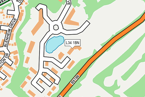
L34 1BN is located in the St Michaels electoral ward, within the metropolitan district of Knowsley and the English Parliamentary constituency of Knowsley. The Sub Integrated Care Board (ICB) Location is NHS Cheshire and Merseyside ICB - 01J and the police force is Merseyside. This postcode has been in use since March 2009.


GetTheData
Source: OS OpenMap – Local (Ordnance Survey)
Source: OS VectorMap District (Ordnance Survey)
Licence: Open Government Licence (requires attribution)
| Easting | 345354 |
| Northing | 392224 |
| Latitude | 53.423965 |
| Longitude | -2.823798 |
GetTheData
Source: Open Postcode Geo
Licence: Open Government Licence
| Country | England |
| Postcode District | L34 |
➜ See where L34 is on a map ➜ Where is Huyton with Roby? | |
GetTheData
Source: Land Registry Price Paid Data
Licence: Open Government Licence
Elevation or altitude of L34 1BN as distance above sea level:
| Metres | Feet | |
|---|---|---|
| Elevation | 60m | 197ft |
Elevation is measured from the approximate centre of the postcode, to the nearest point on an OS contour line from OS Terrain 50, which has contour spacing of ten vertical metres.
➜ How high above sea level am I? Find the elevation of your current position using your device's GPS.
GetTheData
Source: Open Postcode Elevation
Licence: Open Government Licence
| Ward | St Michaels |
| Constituency | Knowsley |
GetTheData
Source: ONS Postcode Database
Licence: Open Government Licence
| Huyton Lane | Knowsley | 98m |
| Carr Lane (Huyton Lane) | Knowsley | 153m |
| Hurst Park Drive (Huyton Lane) | Knowsley | 326m |
| Blenheim Drive (Liverpool Road) | Knowsley | 338m |
| Hurst Park Drive (Huyton Lane) | Knowsley | 344m |
| Prescot Station | 1.6km |
| Huyton Station | 2km |
| Whiston Station | 2.1km |
GetTheData
Source: NaPTAN
Licence: Open Government Licence
GetTheData
Source: ONS Postcode Database
Licence: Open Government Licence


➜ Get more ratings from the Food Standards Agency
GetTheData
Source: Food Standards Agency
Licence: FSA terms & conditions
| Last Collection | |||
|---|---|---|---|
| Location | Mon-Fri | Sat | Distance |
| Police Station/ High Street | 17:30 | 12:00 | 1,173m |
| Glade Road | 17:00 | 12:00 | 1,310m |
| Prescot Station | 17:30 | 12:00 | 1,368m |
GetTheData
Source: Dracos
Licence: Creative Commons Attribution-ShareAlike
The below table lists the International Territorial Level (ITL) codes (formerly Nomenclature of Territorial Units for Statistics (NUTS) codes) and Local Administrative Units (LAU) codes for L34 1BN:
| ITL 1 Code | Name |
|---|---|
| TLD | North West (England) |
| ITL 2 Code | Name |
| TLD7 | Merseyside |
| ITL 3 Code | Name |
| TLD71 | East Merseyside |
| LAU 1 Code | Name |
| E08000011 | Knowsley |
GetTheData
Source: ONS Postcode Directory
Licence: Open Government Licence
The below table lists the Census Output Area (OA), Lower Layer Super Output Area (LSOA), and Middle Layer Super Output Area (MSOA) for L34 1BN:
| Code | Name | |
|---|---|---|
| OA | E00032752 | |
| LSOA | E01006465 | Knowsley 011A |
| MSOA | E02001337 | Knowsley 011 |
GetTheData
Source: ONS Postcode Directory
Licence: Open Government Licence
| L34 1BH | Kings Drive | 120m |
| L34 1PJ | Kings Drive | 174m |
| L34 1BD | Kings Drive | 217m |
| L34 1PP | Osborne Grove | 249m |
| L34 1QF | Dulson Way | 274m |
| L36 1TH | Huyton Lane | 278m |
| L36 1UA | Fairway | 297m |
| L34 1PL | Westminster Grove | 302m |
| L34 1PW | Hollyrood | 313m |
| L34 1PR | Kensington Drive | 321m |
GetTheData
Source: Open Postcode Geo; Land Registry Price Paid Data
Licence: Open Government Licence