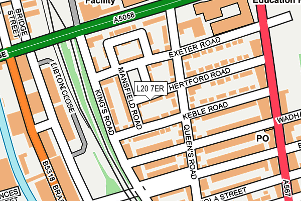
L20 7ER lies on Hertford Road in Liverpool. L20 7ER is located in the Linacre electoral ward, within the metropolitan district of Sefton and the English Parliamentary constituency of Bootle. The Sub Integrated Care Board (ICB) Location is NHS Cheshire and Merseyside ICB - 01T and the police force is Merseyside. This postcode has been in use since October 2013.


GetTheData
Source: OS OpenMap – Local (Ordnance Survey)
Source: OS VectorMap District (Ordnance Survey)
Licence: Open Government Licence (requires attribution)
| Easting | 334195 |
| Northing | 394527 |
| Latitude | 53.443386 |
| Longitude | -2.992180 |
GetTheData
Source: Open Postcode Geo
Licence: Open Government Licence
| Street | Hertford Road |
| Town/City | Liverpool |
| Country | England |
| Postcode District | L20 |
➜ See where L20 is on a map ➜ Where is Bootle? | |
GetTheData
Source: Land Registry Price Paid Data
Licence: Open Government Licence
Elevation or altitude of L20 7ER as distance above sea level:
| Metres | Feet | |
|---|---|---|
| Elevation | 20m | 66ft |
Elevation is measured from the approximate centre of the postcode, to the nearest point on an OS contour line from OS Terrain 50, which has contour spacing of ten vertical metres.
➜ How high above sea level am I? Find the elevation of your current position using your device's GPS.
GetTheData
Source: Open Postcode Elevation
Licence: Open Government Licence
| Ward | Linacre |
| Constituency | Bootle |
GetTheData
Source: ONS Postcode Database
Licence: Open Government Licence
20, HERTFORD ROAD, LIVERPOOL, L20 7ER 2013 27 JUN £159,995 |
GetTheData
Source: HM Land Registry Price Paid Data
Licence: Contains HM Land Registry data © Crown copyright and database right 2025. This data is licensed under the Open Government Licence v3.0.
| Marble Close (Balliol Road) | Bootle | 170m |
| College View (Balliol Road) | Bootle | 193m |
| Wadham Road (Stanley Road) | Bootle | 239m |
| Hugh Baird College (Balliol Road) | Bootle | 248m |
| Beatrice Street (Stanley Road) | Bootle | 304m |
| Bootle Oriel Road Station | 0.4km |
| Bank Hall Station | 0.7km |
| Kirkdale Station | 0.8km |
GetTheData
Source: NaPTAN
Licence: Open Government Licence
| Percentage of properties with Next Generation Access | 100.0% |
| Percentage of properties with Superfast Broadband | 100.0% |
| Percentage of properties with Ultrafast Broadband | 100.0% |
| Percentage of properties with Full Fibre Broadband | 0.0% |
Superfast Broadband is between 30Mbps and 300Mbps
Ultrafast Broadband is > 300Mbps
| Median download speed | 100.0Mbps |
| Average download speed | 93.8Mbps |
| Maximum download speed | 200.00Mbps |
| Median upload speed | 1.2Mbps |
| Average upload speed | 1.0Mbps |
| Maximum upload speed | 1.20Mbps |
| Percentage of properties unable to receive 2Mbps | 0.0% |
| Percentage of properties unable to receive 5Mbps | 0.0% |
| Percentage of properties unable to receive 10Mbps | 0.0% |
| Percentage of properties unable to receive 30Mbps | 0.0% |
GetTheData
Source: Ofcom
Licence: Ofcom Terms of Use (requires attribution)
GetTheData
Source: ONS Postcode Database
Licence: Open Government Licence


➜ Get more ratings from the Food Standards Agency
GetTheData
Source: Food Standards Agency
Licence: FSA terms & conditions
| Last Collection | |||
|---|---|---|---|
| Location | Mon-Fri | Sat | Distance |
| Boundary Street | 16:15 | 12:00 | 661m |
| Bootle New Strand Post Office | 18:00 | 12:00 | 825m |
| Litherland Road | 17:15 | 12:00 | 1,002m |
GetTheData
Source: Dracos
Licence: Creative Commons Attribution-ShareAlike
The below table lists the International Territorial Level (ITL) codes (formerly Nomenclature of Territorial Units for Statistics (NUTS) codes) and Local Administrative Units (LAU) codes for L20 7ER:
| ITL 1 Code | Name |
|---|---|
| TLD | North West (England) |
| ITL 2 Code | Name |
| TLD7 | Merseyside |
| ITL 3 Code | Name |
| TLD73 | Sefton |
| LAU 1 Code | Name |
| E08000014 | Sefton |
GetTheData
Source: ONS Postcode Directory
Licence: Open Government Licence
The below table lists the Census Output Area (OA), Lower Layer Super Output Area (LSOA), and Middle Layer Super Output Area (MSOA) for L20 7ER:
| Code | Name | |
|---|---|---|
| OA | E00035502 | |
| LSOA | E01007010 | Sefton 037E |
| MSOA | E02001465 | Sefton 037 |
GetTheData
Source: ONS Postcode Directory
Licence: Open Government Licence
| L20 7ES | Nuffield Road | 48m |
| L20 7EF | Mansfield Road | 54m |
| L20 7ED | Keble Road | 68m |
| L20 7BQ | Kings Road | 82m |
| L20 7BW | 84m | |
| L20 7EQ | Exeter Road | 90m |
| L20 7DG | Wadham Road | 91m |
| L20 7BT | Queens Road | 91m |
| L20 7BP | Queens Road | 113m |
| L20 7EB | Lincoln Crescent | 125m |
GetTheData
Source: Open Postcode Geo; Land Registry Price Paid Data
Licence: Open Government Licence