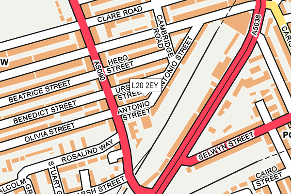
L20 2EY lies on Antonio Street in Bootle. L20 2EY is located in the Derby electoral ward, within the metropolitan district of Sefton and the English Parliamentary constituency of Bootle. The Sub Integrated Care Board (ICB) Location is NHS Cheshire and Merseyside ICB - 01T and the police force is Merseyside. This postcode has been in use since January 1980.


GetTheData
Source: OS OpenMap – Local (Ordnance Survey)
Source: OS VectorMap District (Ordnance Survey)
Licence: Open Government Licence (requires attribution)
| Easting | 334987 |
| Northing | 394452 |
| Latitude | 53.442810 |
| Longitude | -2.980242 |
GetTheData
Source: Open Postcode Geo
Licence: Open Government Licence
| Street | Antonio Street |
| Town/City | Bootle |
| Country | England |
| Postcode District | L20 |
➜ See where L20 is on a map ➜ Where is Bootle? | |
GetTheData
Source: Land Registry Price Paid Data
Licence: Open Government Licence
Elevation or altitude of L20 2EY as distance above sea level:
| Metres | Feet | |
|---|---|---|
| Elevation | 30m | 98ft |
Elevation is measured from the approximate centre of the postcode, to the nearest point on an OS contour line from OS Terrain 50, which has contour spacing of ten vertical metres.
➜ How high above sea level am I? Find the elevation of your current position using your device's GPS.
GetTheData
Source: Open Postcode Elevation
Licence: Open Government Licence
| Ward | Derby |
| Constituency | Bootle |
GetTheData
Source: ONS Postcode Database
Licence: Open Government Licence
19, ANTONIO STREET, BOOTLE, L20 2EY 2003 31 JUL £30,000 |
GetTheData
Source: HM Land Registry Price Paid Data
Licence: Contains HM Land Registry data © Crown copyright and database right 2025. This data is licensed under the Open Government Licence v3.0.
| Hero Street (Hawthorne Road) | Bootle | 125m |
| Marsh Lane (Westminster Road) | Kirkdale | 165m |
| Selwyn Street (Westminster Road) | Kirkdale | 167m |
| Brewster Street (Selwyn Street) | Kirkdale | 167m |
| Roxburgh Street (Brewster Street) | Bootle | 237m |
| Kirkdale Station | 0.2km |
| Bank Hall Station | 0.8km |
| Bootle Oriel Road Station | 1.1km |
GetTheData
Source: NaPTAN
Licence: Open Government Licence
| Percentage of properties with Next Generation Access | 100.0% |
| Percentage of properties with Superfast Broadband | 100.0% |
| Percentage of properties with Ultrafast Broadband | 97.4% |
| Percentage of properties with Full Fibre Broadband | 0.0% |
Superfast Broadband is between 30Mbps and 300Mbps
Ultrafast Broadband is > 300Mbps
| Median download speed | 50.0Mbps |
| Average download speed | 90.2Mbps |
| Maximum download speed | 350.00Mbps |
| Median upload speed | 1.3Mbps |
| Average upload speed | 5.3Mbps |
| Maximum upload speed | 20.00Mbps |
| Percentage of properties unable to receive 2Mbps | 0.0% |
| Percentage of properties unable to receive 5Mbps | 0.0% |
| Percentage of properties unable to receive 10Mbps | 0.0% |
| Percentage of properties unable to receive 30Mbps | 0.0% |
GetTheData
Source: Ofcom
Licence: Ofcom Terms of Use (requires attribution)
Estimated total energy consumption in L20 2EY by fuel type, 2015.
| Consumption (kWh) | 283,433 |
|---|---|
| Meter count | 38 |
| Mean (kWh/meter) | 7,459 |
| Median (kWh/meter) | 6,589 |
| Consumption (kWh) | 112,253 |
|---|---|
| Meter count | 37 |
| Mean (kWh/meter) | 3,034 |
| Median (kWh/meter) | 2,797 |
GetTheData
Source: Postcode level gas estimates: 2015 (experimental)
Source: Postcode level electricity estimates: 2015 (experimental)
Licence: Open Government Licence
GetTheData
Source: ONS Postcode Database
Licence: Open Government Licence


➜ Get more ratings from the Food Standards Agency
GetTheData
Source: Food Standards Agency
Licence: FSA terms & conditions
| Last Collection | |||
|---|---|---|---|
| Location | Mon-Fri | Sat | Distance |
| County Road Post Office | 17:00 | 12:00 | 766m |
| Litherland Road | 17:15 | 12:00 | 1,096m |
| Bootle New Strand Post Office | 18:00 | 12:00 | 1,141m |
GetTheData
Source: Dracos
Licence: Creative Commons Attribution-ShareAlike
The below table lists the International Territorial Level (ITL) codes (formerly Nomenclature of Territorial Units for Statistics (NUTS) codes) and Local Administrative Units (LAU) codes for L20 2EY:
| ITL 1 Code | Name |
|---|---|
| TLD | North West (England) |
| ITL 2 Code | Name |
| TLD7 | Merseyside |
| ITL 3 Code | Name |
| TLD73 | Sefton |
| LAU 1 Code | Name |
| E08000014 | Sefton |
GetTheData
Source: ONS Postcode Directory
Licence: Open Government Licence
The below table lists the Census Output Area (OA), Lower Layer Super Output Area (LSOA), and Middle Layer Super Output Area (MSOA) for L20 2EY:
| Code | Name | |
|---|---|---|
| OA | E00035289 | |
| LSOA | E01006963 | Sefton 038D |
| MSOA | E02001466 | Sefton 038 |
GetTheData
Source: ONS Postcode Directory
Licence: Open Government Licence
| L20 2EX | Ursula Street | 44m |
| L20 2DN | Hawthorne Road | 59m |
| L4 3TF | Westminster Road | 78m |
| L20 2DG | Hawthorne Road | 88m |
| L20 2HA | Hero Street | 91m |
| L20 9NB | Bedford Road | 105m |
| L4 3TL | Brewster Street | 109m |
| L20 2DW | Hawthorne Road | 112m |
| L20 2EU | Antonio Street | 124m |
| L20 9NG | Brewster Street | 137m |
GetTheData
Source: Open Postcode Geo; Land Registry Price Paid Data
Licence: Open Government Licence