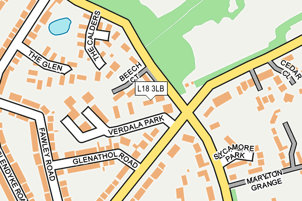
L18 3LB lies on Verdala Park in Liverpool. L18 3LB is located in the Allerton electoral ward, within the metropolitan district of Liverpool and the English Parliamentary constituency of Liverpool, Wavertree. The Sub Integrated Care Board (ICB) Location is NHS Cheshire and Merseyside ICB - 99A and the police force is Merseyside. This postcode has been in use since January 1980.


GetTheData
Source: OS OpenMap – Local (Ordnance Survey)
Source: OS VectorMap District (Ordnance Survey)
Licence: Open Government Licence (requires attribution)
| Easting | 340539 |
| Northing | 386990 |
| Latitude | 53.376403 |
| Longitude | -2.895259 |
GetTheData
Source: Open Postcode Geo
Licence: Open Government Licence
| Street | Verdala Park |
| Town/City | Liverpool |
| Country | England |
| Postcode District | L18 |
➜ See where L18 is on a map ➜ Where is Liverpool? | |
GetTheData
Source: Land Registry Price Paid Data
Licence: Open Government Licence
Elevation or altitude of L18 3LB as distance above sea level:
| Metres | Feet | |
|---|---|---|
| Elevation | 40m | 131ft |
Elevation is measured from the approximate centre of the postcode, to the nearest point on an OS contour line from OS Terrain 50, which has contour spacing of ten vertical metres.
➜ How high above sea level am I? Find the elevation of your current position using your device's GPS.
GetTheData
Source: Open Postcode Elevation
Licence: Open Government Licence
| Ward | Allerton |
| Constituency | Liverpool, Wavertree |
GetTheData
Source: ONS Postcode Database
Licence: Open Government Licence
| Gressingham Road (Mather Avenue) | Calderstones Park | 425m |
| Gressingham Road (Mather Avenue) | Calderstones Park | 457m |
| Booker Avenue (Mather Avenue) | Calderstones Park | 459m |
| Wheatcroft Road (Mather Avenue) | Calderstones Park | 473m |
| Ballantrae Road (Mather Avenue) | Allerton | 536m |
| West Allerton Station | 1.1km |
| Mossley Hill Station | 1.4km |
| Liverpool South Parkway Station | 2.1km |
GetTheData
Source: NaPTAN
Licence: Open Government Licence
| Percentage of properties with Next Generation Access | 100.0% |
| Percentage of properties with Superfast Broadband | 100.0% |
| Percentage of properties with Ultrafast Broadband | 100.0% |
| Percentage of properties with Full Fibre Broadband | 0.0% |
Superfast Broadband is between 30Mbps and 300Mbps
Ultrafast Broadband is > 300Mbps
| Median download speed | 26.4Mbps |
| Average download speed | 46.3Mbps |
| Maximum download speed | 200.00Mbps |
| Median upload speed | 2.5Mbps |
| Average upload speed | 3.1Mbps |
| Maximum upload speed | 7.18Mbps |
| Percentage of properties unable to receive 2Mbps | 0.0% |
| Percentage of properties unable to receive 5Mbps | 0.0% |
| Percentage of properties unable to receive 10Mbps | 0.0% |
| Percentage of properties unable to receive 30Mbps | 0.0% |
GetTheData
Source: Ofcom
Licence: Ofcom Terms of Use (requires attribution)
Estimated total energy consumption in L18 3LB by fuel type, 2015.
| Consumption (kWh) | 281,786 |
|---|---|
| Meter count | 38 |
| Mean (kWh/meter) | 7,415 |
| Median (kWh/meter) | 6,452 |
| Consumption (kWh) | 82,569 |
|---|---|
| Meter count | 32 |
| Mean (kWh/meter) | 2,580 |
| Median (kWh/meter) | 1,972 |
GetTheData
Source: Postcode level gas estimates: 2015 (experimental)
Source: Postcode level electricity estimates: 2015 (experimental)
Licence: Open Government Licence
GetTheData
Source: ONS Postcode Database
Licence: Open Government Licence


➜ Get more ratings from the Food Standards Agency
GetTheData
Source: Food Standards Agency
Licence: FSA terms & conditions
| Last Collection | |||
|---|---|---|---|
| Location | Mon-Fri | Sat | Distance |
| Yewtree Road | 17:15 | 12:00 | 112m |
| Ballantrae Road | 17:15 | 12:00 | 547m |
| Moorecroft Road | 17:15 | 12:00 | 566m |
GetTheData
Source: Dracos
Licence: Creative Commons Attribution-ShareAlike
The below table lists the International Territorial Level (ITL) codes (formerly Nomenclature of Territorial Units for Statistics (NUTS) codes) and Local Administrative Units (LAU) codes for L18 3LB:
| ITL 1 Code | Name |
|---|---|
| TLD | North West (England) |
| ITL 2 Code | Name |
| TLD7 | Merseyside |
| ITL 3 Code | Name |
| TLD72 | Liverpool |
| LAU 1 Code | Name |
| E08000012 | Liverpool |
GetTheData
Source: ONS Postcode Directory
Licence: Open Government Licence
The below table lists the Census Output Area (OA), Lower Layer Super Output Area (LSOA), and Middle Layer Super Output Area (MSOA) for L18 3LB:
| Code | Name | |
|---|---|---|
| OA | E00033115 | |
| LSOA | E01006539 | Liverpool 047B |
| MSOA | E02001393 | Liverpool 047 |
GetTheData
Source: ONS Postcode Directory
Licence: Open Government Licence
| L18 3JZ | Beech Court | 48m |
| L18 3JY | Allerton Road | 50m |
| L18 3LA | Allerton Court | 119m |
| L18 3LD | Verdala Park | 158m |
| L18 3LN | The Calders | 158m |
| L18 3JS | Glenathol Road | 159m |
| L18 6LB | The Glen | 206m |
| L18 9TE | Fawley Road | 220m |
| L18 3LP | Sycamore Park | 222m |
| L18 3JT | Allerton Road | 223m |
GetTheData
Source: Open Postcode Geo; Land Registry Price Paid Data
Licence: Open Government Licence