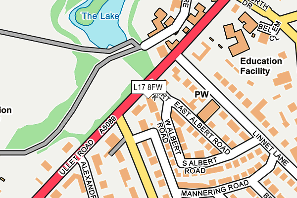
L17 8FW is located in the Sefton Park electoral ward, within the metropolitan district of Liverpool and the English Parliamentary constituency of Liverpool, Riverside. The Sub Integrated Care Board (ICB) Location is NHS Cheshire and Merseyside ICB - 99A and the police force is Merseyside. This postcode has been in use since December 1998.


GetTheData
Source: OS OpenMap – Local (Ordnance Survey)
Source: OS VectorMap District (Ordnance Survey)
Licence: Open Government Licence (requires attribution)
| Easting | 336878 |
| Northing | 387996 |
| Latitude | 53.385018 |
| Longitude | -2.950483 |
GetTheData
Source: Open Postcode Geo
Licence: Open Government Licence
| Country | England |
| Postcode District | L17 |
➜ See where L17 is on a map ➜ Where is Liverpool? | |
GetTheData
Source: Land Registry Price Paid Data
Licence: Open Government Licence
Elevation or altitude of L17 8FW as distance above sea level:
| Metres | Feet | |
|---|---|---|
| Elevation | 40m | 131ft |
Elevation is measured from the approximate centre of the postcode, to the nearest point on an OS contour line from OS Terrain 50, which has contour spacing of ten vertical metres.
➜ How high above sea level am I? Find the elevation of your current position using your device's GPS.
GetTheData
Source: Open Postcode Elevation
Licence: Open Government Licence
| Ward | Sefton Park |
| Constituency | Liverpool, Riverside |
GetTheData
Source: ONS Postcode Database
Licence: Open Government Licence
| Ullet Road (Parkfield Road) | Princes Park | 79m |
| Little Parkfield Road (Parkfield Road) | Princes Park | 97m |
| Windermere Terrace (Ullet Road) | Princes Park | 194m |
| Aigburth Drive (Ullet Road) | Princes Park | 226m |
| Princes Park (Ullet Road) | Princes Park | 302m |
| St Michaels Station | 1.1km |
| Brunswick Station | 1.7km |
| Edge Hill Station | 2km |
GetTheData
Source: NaPTAN
Licence: Open Government Licence
GetTheData
Source: ONS Postcode Database
Licence: Open Government Licence


➜ Get more ratings from the Food Standards Agency
GetTheData
Source: Food Standards Agency
Licence: FSA terms & conditions
| Last Collection | |||
|---|---|---|---|
| Location | Mon-Fri | Sat | Distance |
| Parkfield Road | 17:30 | 12:00 | 80m |
| Sefton Park Road | 17:30 | 12:00 | 286m |
| Belvidere Road | 17:15 | 12:00 | 436m |
GetTheData
Source: Dracos
Licence: Creative Commons Attribution-ShareAlike
The below table lists the International Territorial Level (ITL) codes (formerly Nomenclature of Territorial Units for Statistics (NUTS) codes) and Local Administrative Units (LAU) codes for L17 8FW:
| ITL 1 Code | Name |
|---|---|
| TLD | North West (England) |
| ITL 2 Code | Name |
| TLD7 | Merseyside |
| ITL 3 Code | Name |
| TLD72 | Liverpool |
| LAU 1 Code | Name |
| E08000012 | Liverpool |
GetTheData
Source: ONS Postcode Directory
Licence: Open Government Licence
The below table lists the Census Output Area (OA), Lower Layer Super Output Area (LSOA), and Middle Layer Super Output Area (MSOA) for L17 8FW:
| Code | Name | |
|---|---|---|
| OA | E00033032 | |
| LSOA | E01006520 | Liverpool 043A |
| MSOA | E02001389 | Liverpool 043 |
GetTheData
Source: ONS Postcode Directory
Licence: Open Government Licence
| L17 3BG | Linnet Lane | 88m |
| L17 8UL | Parkfield Road | 95m |
| L17 8TJ | West Albert Road | 99m |
| L8 3SP | Ullet Road | 101m |
| L17 3BH | East Albert Road | 120m |
| L17 8UT | Jardin Mews | 122m |
| L17 8UG | Parkfield Road | 127m |
| L8 3SX | Ullet Road | 148m |
| L17 8UH | Parkfield Road | 165m |
| L17 8TN | South Albert Road | 199m |
GetTheData
Source: Open Postcode Geo; Land Registry Price Paid Data
Licence: Open Government Licence