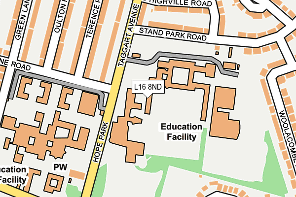
L16 8ND is located in the Childwall electoral ward, within the metropolitan district of Liverpool and the English Parliamentary constituency of Liverpool, Wavertree. The Sub Integrated Care Board (ICB) Location is NHS Cheshire and Merseyside ICB - 99A and the police force is Merseyside. This postcode has been in use since June 1981.


GetTheData
Source: OS OpenMap – Local (Ordnance Survey)
Source: OS VectorMap District (Ordnance Survey)
Licence: Open Government Licence (requires attribution)
| Easting | 340783 |
| Northing | 388668 |
| Latitude | 53.391527 |
| Longitude | -2.891907 |
GetTheData
Source: Open Postcode Geo
Licence: Open Government Licence
| Country | England |
| Postcode District | L16 |
➜ See where L16 is on a map ➜ Where is Liverpool? | |
GetTheData
Source: Land Registry Price Paid Data
Licence: Open Government Licence
Elevation or altitude of L16 8ND as distance above sea level:
| Metres | Feet | |
|---|---|---|
| Elevation | 60m | 197ft |
Elevation is measured from the approximate centre of the postcode, to the nearest point on an OS contour line from OS Terrain 50, which has contour spacing of ten vertical metres.
➜ How high above sea level am I? Find the elevation of your current position using your device's GPS.
GetTheData
Source: Open Postcode Elevation
Licence: Open Government Licence
| Ward | Childwall |
| Constituency | Liverpool, Wavertree |
GetTheData
Source: ONS Postcode Database
Licence: Open Government Licence
| Irene Road (Taggart Avenue) | Childwall | 69m |
| Irene Road (Taggart Avenue) | Childwall | 78m |
| Woolton Road (Taggart Avenue) | Childwall | 244m |
| Woolton Road (Taggart Avenue) | Childwall | 253m |
| Taggart Avenue (Woolton Road) | Childwall | 277m |
| Broad Green Station | 1.7km |
| Mossley Hill Station | 2.1km |
| Wavertree Technology Park Station | 2.6km |
GetTheData
Source: NaPTAN
Licence: Open Government Licence
GetTheData
Source: ONS Postcode Database
Licence: Open Government Licence


➜ Get more ratings from the Food Standards Agency
GetTheData
Source: Food Standards Agency
Licence: FSA terms & conditions
| Last Collection | |||
|---|---|---|---|
| Location | Mon-Fri | Sat | Distance |
| Cromptons Lane | 16:00 | 12:00 | 299m |
| Chidwall Post Office | 16:45 | 12:00 | 326m |
| Standpark Road | 16:00 | 12:00 | 381m |
GetTheData
Source: Dracos
Licence: Creative Commons Attribution-ShareAlike
The below table lists the International Territorial Level (ITL) codes (formerly Nomenclature of Territorial Units for Statistics (NUTS) codes) and Local Administrative Units (LAU) codes for L16 8ND:
| ITL 1 Code | Name |
|---|---|
| TLD | North West (England) |
| ITL 2 Code | Name |
| TLD7 | Merseyside |
| ITL 3 Code | Name |
| TLD72 | Liverpool |
| LAU 1 Code | Name |
| E08000012 | Liverpool |
GetTheData
Source: ONS Postcode Directory
Licence: Open Government Licence
The below table lists the Census Output Area (OA), Lower Layer Super Output Area (LSOA), and Middle Layer Super Output Area (MSOA) for L16 8ND:
| Code | Name | |
|---|---|---|
| OA | E00176771 | |
| LSOA | E01006583 | Liverpool 047C |
| MSOA | E02001393 | Liverpool 047 |
GetTheData
Source: ONS Postcode Directory
Licence: Open Government Licence
| L16 9JA | Taggart Avenue | 169m |
| L16 8NW | Terence Road | 186m |
| L16 9JH | South Highville Road | 191m |
| L16 8NN | Terence Road | 207m |
| L16 9JB | Taggart Avenue | 216m |
| L16 9JL | Stand Park Road | 221m |
| L16 8NR | Oulton Road | 236m |
| L16 8NP | Oulton Road | 254m |
| L16 9JF | Highville Road | 254m |
| L16 9JE | Highville Road | 266m |
GetTheData
Source: Open Postcode Geo; Land Registry Price Paid Data
Licence: Open Government Licence