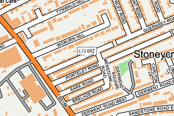
L13 6RZ lies on Guernsey Road in Liverpool. L13 6RZ is located in the Stoneycroft electoral ward, within the metropolitan district of Liverpool and the English Parliamentary constituency of Liverpool, Wavertree. The Sub Integrated Care Board (ICB) Location is NHS Cheshire and Merseyside ICB - 99A and the police force is Merseyside. This postcode has been in use since January 1980.


GetTheData
Source: OS OpenMap – Local (Ordnance Survey)
Source: OS VectorMap District (Ordnance Survey)
Licence: Open Government Licence (requires attribution)
| Easting | 338890 |
| Northing | 391833 |
| Latitude | 53.419740 |
| Longitude | -2.920982 |
GetTheData
Source: Open Postcode Geo
Licence: Open Government Licence
| Street | Guernsey Road |
| Town/City | Liverpool |
| Country | England |
| Postcode District | L13 |
➜ See where L13 is on a map ➜ Where is Liverpool? | |
GetTheData
Source: Land Registry Price Paid Data
Licence: Open Government Licence
Elevation or altitude of L13 6RZ as distance above sea level:
| Metres | Feet | |
|---|---|---|
| Elevation | 50m | 164ft |
Elevation is measured from the approximate centre of the postcode, to the nearest point on an OS contour line from OS Terrain 50, which has contour spacing of ten vertical metres.
➜ How high above sea level am I? Find the elevation of your current position using your device's GPS.
GetTheData
Source: Open Postcode Elevation
Licence: Open Government Licence
| Ward | Stoneycroft |
| Constituency | Liverpool, Wavertree |
GetTheData
Source: ONS Postcode Database
Licence: Open Government Licence
28, GUERNSEY ROAD, LIVERPOOL, L13 6RZ 2003 22 AUG £64,500 |
GetTheData
Source: HM Land Registry Price Paid Data
Licence: Contains HM Land Registry data © Crown copyright and database right 2025. This data is licensed under the Open Government Licence v3.0.
| Sark Road (Green Lane) | Stanley | 174m |
| Brelade Road (Green Lane) | Old Swan | 183m |
| Woburn Hill (Green Lane) | Old Swan | 201m |
| Tynwald Hill (Green Lane) | Old Swan | 243m |
| Bolan Street (Green Lane) | Stanley | 396m |
| Wavertree Technology Park Station | 1.6km |
| Broad Green Station | 2.3km |
| Edge Hill Station | 2.6km |
GetTheData
Source: NaPTAN
Licence: Open Government Licence
| Percentage of properties with Next Generation Access | 100.0% |
| Percentage of properties with Superfast Broadband | 100.0% |
| Percentage of properties with Ultrafast Broadband | 100.0% |
| Percentage of properties with Full Fibre Broadband | 100.0% |
Superfast Broadband is between 30Mbps and 300Mbps
Ultrafast Broadband is > 300Mbps
| Median download speed | 100.0Mbps |
| Average download speed | 106.8Mbps |
| Maximum download speed | 350.00Mbps |
| Median upload speed | 4.5Mbps |
| Average upload speed | 7.8Mbps |
| Maximum upload speed | 20.00Mbps |
| Percentage of properties unable to receive 2Mbps | 0.0% |
| Percentage of properties unable to receive 5Mbps | 0.0% |
| Percentage of properties unable to receive 10Mbps | 0.0% |
| Percentage of properties unable to receive 30Mbps | 0.0% |
GetTheData
Source: Ofcom
Licence: Ofcom Terms of Use (requires attribution)
Estimated total energy consumption in L13 6RZ by fuel type, 2015.
| Consumption (kWh) | 569,111 |
|---|---|
| Meter count | 42 |
| Mean (kWh/meter) | 13,550 |
| Median (kWh/meter) | 12,288 |
| Consumption (kWh) | 151,321 |
|---|---|
| Meter count | 38 |
| Mean (kWh/meter) | 3,982 |
| Median (kWh/meter) | 3,630 |
GetTheData
Source: Postcode level gas estimates: 2015 (experimental)
Source: Postcode level electricity estimates: 2015 (experimental)
Licence: Open Government Licence
GetTheData
Source: ONS Postcode Database
Licence: Open Government Licence

➜ Get more ratings from the Food Standards Agency
GetTheData
Source: Food Standards Agency
Licence: FSA terms & conditions
| Last Collection | |||
|---|---|---|---|
| Location | Mon-Fri | Sat | Distance |
| Derby Lane | 17:30 | 12:00 | 442m |
| Old Swan Post Office | 17:00 | 12:00 | 545m |
| Mill Bank | 17:15 | 12:00 | 794m |
GetTheData
Source: Dracos
Licence: Creative Commons Attribution-ShareAlike
The below table lists the International Territorial Level (ITL) codes (formerly Nomenclature of Territorial Units for Statistics (NUTS) codes) and Local Administrative Units (LAU) codes for L13 6RZ:
| ITL 1 Code | Name |
|---|---|
| TLD | North West (England) |
| ITL 2 Code | Name |
| TLD7 | Merseyside |
| ITL 3 Code | Name |
| TLD72 | Liverpool |
| LAU 1 Code | Name |
| E08000012 | Liverpool |
GetTheData
Source: ONS Postcode Directory
Licence: Open Government Licence
The below table lists the Census Output Area (OA), Lower Layer Super Output Area (LSOA), and Middle Layer Super Output Area (MSOA) for L13 6RZ:
| Code | Name | |
|---|---|---|
| OA | E00034038 | |
| LSOA | E01006718 | Liverpool 027E |
| MSOA | E02001373 | Liverpool 027 |
GetTheData
Source: ONS Postcode Directory
Licence: Open Government Licence
| L13 6RN | Guernsey Road | 24m |
| L13 6SE | Portelet Road | 52m |
| L13 6RL | Woburn Hill | 62m |
| L13 6QU | Sark Road | 100m |
| L13 6RA | Menstone Road | 101m |
| L13 6RB | Brelade Road | 132m |
| L13 6RJ | Woburn Green | 145m |
| L13 6RQ | Green Lane | 145m |
| L13 6SQ | Portelet Road | 163m |
| L13 6SF | Portelet Road | 170m |
GetTheData
Source: Open Postcode Geo; Land Registry Price Paid Data
Licence: Open Government Licence