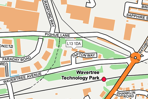
L13 1DA lies on Tapton Way in Liverpool. L13 1DA is located in the Old Swan West electoral ward, within the metropolitan district of Liverpool and the English Parliamentary constituency of Liverpool, Wavertree. The Sub Integrated Care Board (ICB) Location is NHS Cheshire and Merseyside ICB - 99A and the police force is Merseyside. This postcode has been in use since October 2003.


GetTheData
Source: OS OpenMap – Local (Ordnance Survey)
Source: OS VectorMap District (Ordnance Survey)
Licence: Open Government Licence (requires attribution)
| Easting | 338621 |
| Northing | 390336 |
| Latitude | 53.406255 |
| Longitude | -2.924737 |
GetTheData
Source: Open Postcode Geo
Licence: Open Government Licence
| Street | Tapton Way |
| Town/City | Liverpool |
| Country | England |
| Postcode District | L13 |
➜ See where L13 is on a map ➜ Where is Liverpool? | |
GetTheData
Source: Land Registry Price Paid Data
Licence: Open Government Licence
Elevation or altitude of L13 1DA as distance above sea level:
| Metres | Feet | |
|---|---|---|
| Elevation | 50m | 164ft |
Elevation is measured from the approximate centre of the postcode, to the nearest point on an OS contour line from OS Terrain 50, which has contour spacing of ten vertical metres.
➜ How high above sea level am I? Find the elevation of your current position using your device's GPS.
GetTheData
Source: Open Postcode Elevation
Licence: Open Government Licence
| Ward | Old Swan West |
| Constituency | Liverpool, Wavertree |
GetTheData
Source: ONS Postcode Database
Licence: Open Government Licence
| Rathbone Road (Wavertree Avenue) | Wavertree Technology Park | 205m |
| Edge Lane Retail Park (Binns Road) | Old Swan | 211m |
| Stephenson Way (Wavertree Avenue) | Wavertree Technology Park | 220m |
| Ventnor Road (Rathbone Road) | Wavertree | 317m |
| Sapphire Street (Rathbone Road) | Old Swan | 321m |
| Wavertree Technology Park Station | 0.2km |
| Edge Hill Station | 1.5km |
| Broad Green Station | 2.1km |
GetTheData
Source: NaPTAN
Licence: Open Government Licence
| Median download speed | 9.0Mbps |
| Average download speed | 8.6Mbps |
| Maximum download speed | 9.96Mbps |
| Median upload speed | 0.9Mbps |
| Average upload speed | 0.9Mbps |
| Maximum upload speed | 0.99Mbps |
GetTheData
Source: Ofcom
Licence: Ofcom Terms of Use (requires attribution)
GetTheData
Source: ONS Postcode Database
Licence: Open Government Licence

➜ Get more ratings from the Food Standards Agency
GetTheData
Source: Food Standards Agency
Licence: FSA terms & conditions
| Last Collection | |||
|---|---|---|---|
| Location | Mon-Fri | Sat | Distance |
| Church Road | 16:00 | 12:00 | 456m |
| Sandown Lane | 16:00 | 12:00 | 509m |
| Rathbone Road | 16:00 | 12:00 | 509m |
GetTheData
Source: Dracos
Licence: Creative Commons Attribution-ShareAlike
The below table lists the International Territorial Level (ITL) codes (formerly Nomenclature of Territorial Units for Statistics (NUTS) codes) and Local Administrative Units (LAU) codes for L13 1DA:
| ITL 1 Code | Name |
|---|---|
| TLD | North West (England) |
| ITL 2 Code | Name |
| TLD7 | Merseyside |
| ITL 3 Code | Name |
| TLD72 | Liverpool |
| LAU 1 Code | Name |
| E08000012 | Liverpool |
GetTheData
Source: ONS Postcode Directory
Licence: Open Government Licence
The below table lists the Census Output Area (OA), Lower Layer Super Output Area (LSOA), and Middle Layer Super Output Area (MSOA) for L13 1DA:
| Code | Name | |
|---|---|---|
| OA | E00033913 | |
| LSOA | E01006692 | Liverpool 028B |
| MSOA | E02001374 | Liverpool 028 |
GetTheData
Source: ONS Postcode Directory
Licence: Open Government Licence
| L13 1HN | Stephenson Way | 213m |
| L13 1HD | Stephenson Way | 243m |
| L15 4HH | Rathbone Road | 292m |
| L7 9NF | Binns Road | 293m |
| L13 1DJ | Sapphire Street | 306m |
| L15 4HY | Rushbury Court | 307m |
| L15 4JE | Shanklin Road | 318m |
| L13 1BS | Binns Road | 328m |
| L13 1BR | Runic Street | 344m |
| L13 1BA | Rathbone Road | 360m |
GetTheData
Source: Open Postcode Geo; Land Registry Price Paid Data
Licence: Open Government Licence