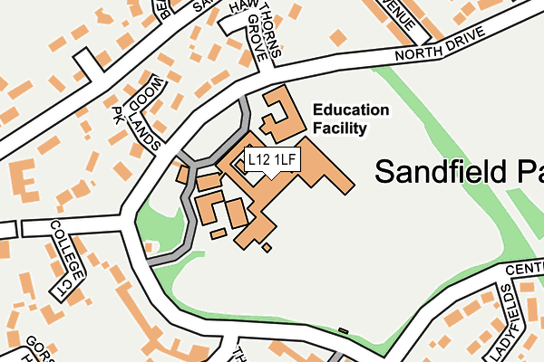
L12 1LF is located in the Sandfield Park electoral ward, within the metropolitan district of Liverpool and the English Parliamentary constituency of Liverpool, West Derby. The Sub Integrated Care Board (ICB) Location is NHS Cheshire and Merseyside ICB - 99A and the police force is Merseyside. This postcode has been in use since January 1980.


GetTheData
Source: OS OpenMap – Local (Ordnance Survey)
Source: OS VectorMap District (Ordnance Survey)
Licence: Open Government Licence (requires attribution)
| Easting | 339608 |
| Northing | 392388 |
| Latitude | 53.424811 |
| Longitude | -2.910286 |
GetTheData
Source: Open Postcode Geo
Licence: Open Government Licence
| Country | England |
| Postcode District | L12 |
➜ See where L12 is on a map ➜ Where is Liverpool? | |
GetTheData
Source: Land Registry Price Paid Data
Licence: Open Government Licence
Elevation or altitude of L12 1LF as distance above sea level:
| Metres | Feet | |
|---|---|---|
| Elevation | 40m | 131ft |
Elevation is measured from the approximate centre of the postcode, to the nearest point on an OS contour line from OS Terrain 50, which has contour spacing of ten vertical metres.
➜ How high above sea level am I? Find the elevation of your current position using your device's GPS.
GetTheData
Source: Open Postcode Elevation
Licence: Open Government Licence
| Ward | Sandfield Park |
| Constituency | Liverpool, West Derby |
GetTheData
Source: ONS Postcode Database
Licence: Open Government Licence
| Central Drive (Queens Drive) | West Derby | 335m |
| Florentine Road (Queens Drive) | Stoneycroft | 359m |
| Quarry Road (Queens Drive) | Stoneycroft | 370m |
| Stoneycroft Crescent (Queens Drive) | Stoneycroft | 377m |
| Queens Drive (Derby Lane) | Stoneycroft | 432m |
| Broad Green Station | 2.3km |
| Wavertree Technology Park Station | 2.3km |
| Edge Hill Station | 3.4km |
GetTheData
Source: NaPTAN
Licence: Open Government Licence
GetTheData
Source: ONS Postcode Database
Licence: Open Government Licence


➜ Get more ratings from the Food Standards Agency
GetTheData
Source: Food Standards Agency
Licence: FSA terms & conditions
| Last Collection | |||
|---|---|---|---|
| Location | Mon-Fri | Sat | Distance |
| Eaton Road North | 16:15 | 12:00 | 583m |
| Derby Lane | 17:30 | 12:00 | 652m |
| Town Row Delivery Office | 17:30 | 12:00 | 663m |
GetTheData
Source: Dracos
Licence: Creative Commons Attribution-ShareAlike
The below table lists the International Territorial Level (ITL) codes (formerly Nomenclature of Territorial Units for Statistics (NUTS) codes) and Local Administrative Units (LAU) codes for L12 1LF:
| ITL 1 Code | Name |
|---|---|
| TLD | North West (England) |
| ITL 2 Code | Name |
| TLD7 | Merseyside |
| ITL 3 Code | Name |
| TLD72 | Liverpool |
| LAU 1 Code | Name |
| E08000012 | Liverpool |
GetTheData
Source: ONS Postcode Directory
Licence: Open Government Licence
The below table lists the Census Output Area (OA), Lower Layer Super Output Area (LSOA), and Middle Layer Super Output Area (MSOA) for L12 1LF:
| Code | Name | |
|---|---|---|
| OA | E00165713 | |
| LSOA | E01006621 | Liverpool 021D |
| MSOA | E02001367 | Liverpool 021 |
GetTheData
Source: ONS Postcode Directory
Licence: Open Government Licence
| L12 1LD | North Drive | 130m |
| L12 1ND | Woodlands Park | 189m |
| L12 1NB | Bracken Way | 200m |
| L12 1NE | Hawthorn Grove | 200m |
| L12 1LH | South Drive | 218m |
| L12 1LS | Bellefield Avenue | 235m |
| L12 1NH | College Court | 253m |
| L12 1LR | Bellefield Avenue | 263m |
| L12 1LP | Beech Park | 267m |
| L12 1LJ | Sandforth Close | 270m |
GetTheData
Source: Open Postcode Geo; Land Registry Price Paid Data
Licence: Open Government Licence