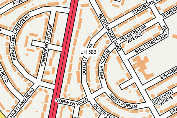
L11 5BB lies on Outer Forum in Liverpool. L11 5BB is located in the Norris Green electoral ward, within the metropolitan district of Liverpool and the English Parliamentary constituency of Liverpool, West Derby. The Sub Integrated Care Board (ICB) Location is NHS Cheshire and Merseyside ICB - 99A and the police force is Merseyside. This postcode has been in use since January 1980.


GetTheData
Source: OS OpenMap – Local (Ordnance Survey)
Source: OS VectorMap District (Ordnance Survey)
Licence: Open Government Licence (requires attribution)
| Easting | 338409 |
| Northing | 395089 |
| Latitude | 53.448947 |
| Longitude | -2.928857 |
GetTheData
Source: Open Postcode Geo
Licence: Open Government Licence
| Street | Outer Forum |
| Town/City | Liverpool |
| Country | England |
| Postcode District | L11 |
➜ See where L11 is on a map ➜ Where is Liverpool? | |
GetTheData
Source: Land Registry Price Paid Data
Licence: Open Government Licence
Elevation or altitude of L11 5BB as distance above sea level:
| Metres | Feet | |
|---|---|---|
| Elevation | 30m | 98ft |
Elevation is measured from the approximate centre of the postcode, to the nearest point on an OS contour line from OS Terrain 50, which has contour spacing of ten vertical metres.
➜ How high above sea level am I? Find the elevation of your current position using your device's GPS.
GetTheData
Source: Open Postcode Elevation
Licence: Open Government Licence
| Ward | Norris Green |
| Constituency | Liverpool, West Derby |
GetTheData
Source: ONS Postcode Database
Licence: Open Government Licence
| Norwyn Road (Townsend Avenue) | Norris Green | 116m |
| Kingsland Crescent (Townsend Avenue) | Walton | 142m |
| Sedgemoor Road | Norris Green | 161m |
| Sedgemoor Road | Norris Green | 165m |
| Sedgemoor Road (Townsend Avenue) | Norris Green | 222m |
| Fazakerley Station | 2.3km |
| Rice Lane Station | 2.4km |
| Walton (Merseyside) Station | 2.6km |
GetTheData
Source: NaPTAN
Licence: Open Government Licence
| Percentage of properties with Next Generation Access | 100.0% |
| Percentage of properties with Superfast Broadband | 100.0% |
| Percentage of properties with Ultrafast Broadband | 100.0% |
| Percentage of properties with Full Fibre Broadband | 0.0% |
Superfast Broadband is between 30Mbps and 300Mbps
Ultrafast Broadband is > 300Mbps
| Median download speed | 70.0Mbps |
| Average download speed | 89.6Mbps |
| Maximum download speed | 200.00Mbps |
| Median upload speed | 16.0Mbps |
| Average upload speed | 11.3Mbps |
| Maximum upload speed | 20.00Mbps |
| Percentage of properties unable to receive 2Mbps | 0.0% |
| Percentage of properties unable to receive 5Mbps | 0.0% |
| Percentage of properties unable to receive 10Mbps | 0.0% |
| Percentage of properties unable to receive 30Mbps | 0.0% |
GetTheData
Source: Ofcom
Licence: Ofcom Terms of Use (requires attribution)
Estimated total energy consumption in L11 5BB by fuel type, 2015.
| Consumption (kWh) | 300,336 |
|---|---|
| Meter count | 26 |
| Mean (kWh/meter) | 11,551 |
| Median (kWh/meter) | 12,043 |
| Consumption (kWh) | 87,227 |
|---|---|
| Meter count | 24 |
| Mean (kWh/meter) | 3,634 |
| Median (kWh/meter) | 3,540 |
GetTheData
Source: Postcode level gas estimates: 2015 (experimental)
Source: Postcode level electricity estimates: 2015 (experimental)
Licence: Open Government Licence
GetTheData
Source: ONS Postcode Database
Licence: Open Government Licence


➜ Get more ratings from the Food Standards Agency
GetTheData
Source: Food Standards Agency
Licence: FSA terms & conditions
| Last Collection | |||
|---|---|---|---|
| Location | Mon-Fri | Sat | Distance |
| Cavendish Drive | 16:00 | 12:00 | 2,230m |
| Rice Lane | 16:00 | 12:00 | 2,262m |
| Longmoor Lane Post Office | 17:00 | 12:00 | 2,267m |
GetTheData
Source: Dracos
Licence: Creative Commons Attribution-ShareAlike
The below table lists the International Territorial Level (ITL) codes (formerly Nomenclature of Territorial Units for Statistics (NUTS) codes) and Local Administrative Units (LAU) codes for L11 5BB:
| ITL 1 Code | Name |
|---|---|
| TLD | North West (England) |
| ITL 2 Code | Name |
| TLD7 | Merseyside |
| ITL 3 Code | Name |
| TLD72 | Liverpool |
| LAU 1 Code | Name |
| E08000012 | Liverpool |
GetTheData
Source: ONS Postcode Directory
Licence: Open Government Licence
The below table lists the Census Output Area (OA), Lower Layer Super Output Area (LSOA), and Middle Layer Super Output Area (MSOA) for L11 5BB:
| Code | Name | |
|---|---|---|
| OA | E00034113 | |
| LSOA | E01006737 | Liverpool 005F |
| MSOA | E02001351 | Liverpool 005 |
GetTheData
Source: ONS Postcode Directory
Licence: Open Government Licence
| L11 5BE | Outer Forum | 30m |
| L11 5AH | Townsend Avenue | 60m |
| L11 5BG | Inner Forum | 64m |
| L11 5BJ | Norwyn Road | 137m |
| L11 3BP | Sedgemoor Road | 142m |
| L11 3BR | Sedgemoor Road | 168m |
| L11 3BN | Sedgemoor Road | 169m |
| L11 7AJ | Townsend Avenue | 172m |
| L11 5BQ | Inner Forum | 184m |
| L11 3DD | Felmersham Avenue | 192m |
GetTheData
Source: Open Postcode Geo; Land Registry Price Paid Data
Licence: Open Government Licence